Sold2017Mitchell: Antique Map of Asia, 1869Title/Content of Map: Asia Date Printed: 1869 Cartographer: Augustus S. Mitchell Material/Medium: Paper Size: 15" x12" Published in Philadelphia. From Mitchell's 'New General Atlas.' Hand colored, engSee Sold Price
Sold2017Persia, Turkey In Asia, Afghanistan, & Beloochistan MapPersia, Turkey in Asia, Afghanistan, and Beloochistan, 15 x 11.75 in, 1869, S. Augustus Mitchell Please note that this lot has a confidential reserve. When you leave a bid in advance of the auction, sSee Sold Price
Sold20241869 Map of the Railroads of New Jersey1869 Map of the Railroads of New Jersey A framed Map of the Railroads of New Jersey dated 1869 from the Pennsylvania Railroad General Office Library. The 19 1/2" x 27 1/2" wooden frame holds a map takSee Sold Price
20231803 Voyages in TIBET Bhutan Panchen Lama Buddhism Campe ASIA MAP Samuel Turner1803 Voyages in TIBET Bhutan Panchen Lama Buddhism Campe ASIA MAP Samuel Turner Joachim Heinrich Campe was an 18th-century German author known for his travelogues and histories of voyages. One of hisSee Sold Price
Sold2023Oceanica exhibiting its various divisions… Pacific Hawaii. MITCHELL 1869 mapTITLE/CONTENT OF MAP: 'Map of Oceanica, Exhibiting its Various Divisions, Island Groups &c // Map of the Sandwich Islands' DATE PRINTED: 1869 IMAGE SIZE: Approx 28.5 x 36.0cm, 11.25 x 14.25 inches (LaSee Sold Price
Sold2022Antique Map of Asia - Map of Northern India - Dabhol - Rigobert BonneTitle: Antique Map of Asia - Map of Northern India - Dabhol - Rigobert Bonne Date/Period: 1780 Dimension: 23 cm x 36 cm Material: Paper Additional Information: Antique map of northern India. Covers thSee Sold Price
Sold2023South America. Proposed Atrato-Inter-Oceanic Canal Routes. MITCHELL 1869 mapTitle: South America. Proposed Atrato-Inter-Oceanic Canal Routes. MITCHELL 1869 map Description: Map of South America showing its Political Divisions // Map of the Proposed Atrato-Inter-Oceanic CanalSee Sold Price
Sold2023New Granada Venezuela Guiana Peru Equador Argentine Argentina MITCHELL 1869 mapTitle: New Granada Venezuela Guiana Peru Equador Argentine Argentina MITCHELL 1869 map Description: Map of New Granada, Venezuela, and Guiana // Map of Peru and Equador // Map of the Argentine ConfedeSee Sold Price
Sold2017Reichard: Ottoman Empire in Asia Map, 1820Map: Ottoman Empire in Asia Map, "Charte des Osmanischen Reichs in Asien" Cartographer: Reichard Place & Date: Weimar / 1820 Size: 24 3/4" x 19" Condition: light overall age toning; an occasional spotSee Sold Price
Sold20241860 Mitchell Map of Asia -- Map of Asia Showing its Gt. Political Divisions?Title: 1860 Mitchell Map of Asia -- Map of Asia Showing its Gt. Political Divisions? Cartographer: S Mitchell Year / Place: 1860, Philadelphia Map Dimension (in.): 10.5 x 13.5 in. A magnificent map ofSee Sold Price
Sold2024North East Africa. Egypt Abyssinia Arabia Abu Dhabi Sharja. COLTON 1869 mapTITLE OF MAP (NOT PRINTED ON THE PAGE):'Africa - north eastern sheet' DATE PRINTED: 1869 IMAGE SIZE: Approx 42.0 x 33.5cm, 16.5 x 13.25 inches (Large) TYPE: Antique engraved hand coloured atlas map COSee Sold Price
Sold20201860 Mitchell Map of Asia -- Map of Asia Showing itsTitle/Content of Map: 1860 Mitchell Map of Asia -- Map of Asia Showing its Gt. Political DivisionsÂ… Cartographer: S Mitchell Year/Place: 1860, Philadelphia Size: 10.5 x 13.5 in. A magnificent mapSee Sold Price
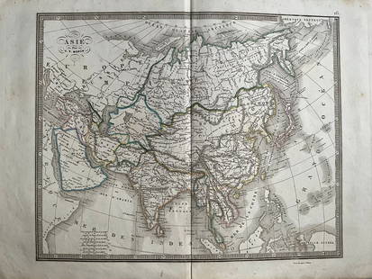
20241839 Asia Map by MoninTitle: 1839 Asia Map by Monin Date/Period: 1839 Materials: Hand colored, engraved Size: 17 1/2 x 12 1/2" This map is an interesting depiction of Asia in 1839 when the continent was still largely unexpSee Sold Price
Sold20181860 Mitchell Map od Asia -- Map of Asia Showing itsTitle/Content of Map: 1860 Mitchell Map od Asia -- Map of Asia Showing its Gt. Political Divisions… Date Printed: 1860, Philadelphia Cartographer: S Mitchell Size: 10.5 x 13.5 in. A magnificent mapSee Sold Price
Sold20211860 Mitchell Map od Asia -- Map of Asia Showing itsTitle: 1860 Mitchell Map od Asia -- Map of Asia Showing its Gt. Political Divisions… Cartographer: S Mitchell Year / Place: 1860, Philadelphia Map Dimension (in.): 10.5 x 13.5 in. A magnificent mapSee Sold Price
Sold20211895 Asia MapAuthor: Cram Title: 1895 Asia Map Medium: Ink on Paper Dimenions: 22"X15" Description: Map of Asia dated 1895. Printed by George Cram for Walker's International Atlas. Published in Chicago and New YorSee Sold Price
Sold20211865 Mitchell Map of Asia -- Map of AsiaTitle: 1865 Mitchell Map of Asia -- Map of Asia Cartographer: S Mitchell Year / Place: 1865, Philadelphia Map Dimension (in.): 8.8 X 10.6 in. This is a handsome Asia map by Mitchell, with color codedSee Sold Price
Sold20231891 Mitchell Map of Asia -- Map of Asia…Title: 1891 Mitchell Map of Asia -- Map of Asia… Cartographer: S Mitchell Year / Place: 1891, Philadelphia Map Dimension (in.): 8.2 X 10.6 in. This is an excellent map of Asia. Inset is PalestinSee Sold Price
Sold20201869 Map of the Sacred LandAuthor: Brehier Title: 1869 Map of the Sacred Land Medium: Ink on Paper Dimensions: 18.5"X13" Description: Map of the Sacred Land dated 1869. Double folio map drawn by Brehier. Published by Belin in PSee Sold Price
Sold20201869 Map of AfricaAuthor: Jenotte Title: 1869 Map of Africa Medium: Ink on Paper Dimensions: 18.5"X13" Double folio map of Africa dated 1869. Drawn by Blechir and engraved by Jenotte. Published in Paris. Color coded foSee Sold Price
Sold20211869 Map of AustraliaTitle: 1869 Map of Australia Author: Jenotte Medium: Ink on paper Dimensions: 18.5"X13" Description: Map of Australia dated 1869. Drawn by Blechir and engraved by Jenotte. Published in Paris. Double fSee Sold Price
Sold20201869 Map of North AmericaAuthor: Brehir Title: 1869 Map of North America Medium: Ink on Paper Dimensions: 18.5"X13' Map of North America dated 1869. Drawn by Brechir and engraved by Jenotte. Published in Paris. Extensive explSee Sold Price
Sold20211869 Map of the Ancient WorldAuthor: Jenotte Title: 1869 Map of the Ancient World Medium: Ink on Paper Dimensions: 18.5"X13" Map of the Ancient World dated 1869. Drawn by Blechir and engraved by Jenotte. Published in Paris. Key lSee Sold Price
Sold20201869 Map of the MediteraneanAuthor: Jenotte Title: 1869 Map of the Mediteranean Medium: Ink on Paper Dimensions: 18.5"X13" Description: Map of the Mediteranean during the Roman Empire dated 1869. Drawn by Blechir and engraved bySee Sold Price
May 14Jasper521869 Mitchell Map of South-Central Europe [verso] Asia -- XXXIV Austria, Switzerland, Italy, Turkey$30
May 14Jasper521869 Mitchell Map of Much of Western Europe -- XXXII Prussia the German States Holland & Belgium$30
May 14Jasper521858 Mitchell Map of Southern Europe and France [verso] Asia -- No. 24 Map of France, Spain,$30
May 14Jasper52Mitchell’s Map of Asia showing travel routes London, India, China & Japan, 1860$45


![1869 Mitchell Map of South-Central Europe [verso] Asia -- XXXIV Austria, Switzerland, Italy, Turkey (1 of 2)](https://p1.liveauctioneers.com/5584/328338/176911683_1_x.jpg?height=282&quality=70&version=1715113718)


![1858 Mitchell Map of Southern Europe and France [verso] Asia -- No. 24 Map of France, Spain, (1 of 2)](https://p1.liveauctioneers.com/5584/328338/176911601_1_x.jpg?height=282&quality=70&version=1715113718)


