Sold2021West Texas 1901Title/Content of Map: West Texas 1901 Date Printed: 1901Material/Medium: Paper Size: approx 14x21.5 inches Fort Dearborn Publ. Co., The National Standard Atlas Reserve: $30.00 Shipping: Domestic: FlSee Sold Price
Sold20211890 Map of West TexasTitle: 1890 Map of West Texas Medium: Ink on Paper Dimensions: 14.5"X22.5" Description: Map of West Texas dated 1890. Engraved and published by George Cram in Chicago. Part of his Family Atlas. DoubleSee Sold Price
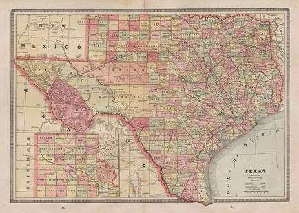
Sold20201884 Map of West TexasAuthor: Cram Title: 1884 Map of West Texas Medium: Ink on Paper Dimensions: 14.5"X21.5" Map of the West portion of Texas dated 1884. Engraved and published by George Cram in Chicago. Part of his WorldSee Sold Price
Sold2017Rand Mcnally & Co.'s Railroad Map Of West TexasRailroad Map of West Texas Rand, McNally & Co. c. 1880, 21 x 14.25 in Please note that this lot has a confidential reserve. When you leave a bid in advance of the auction, submit your maximum. Jasper5See Sold Price
Sold20211901 West Texas MapAuthor: Cram Title: 1901 West Texas Map Medium: Ink on Paper Dimensions: 14.5"X22.5" Map of West Texas dated 1901. Printed and published by George Cram in Chicago. Part of his Family Atlas. Double folSee Sold Price
Sold2019U S Coast Survey 1896 LG Map. West USA California Texas"Sketch of General Progress June 30. 1896." Showing Central and Western US, with part of Mexico. From Mississippi/Wisconsin through to West Coast. Large Lithograph Map Published 1896, Washington for "See Sold Price
Sold20221850 James Map of US West and Texas -- A New Map of Mexico, California & OregonTitle: 1850 James Map of US West and Texas -- A New Map of Mexico, California & Oregon Cartographer: J A & U P James Year / Place: 1850, Cincinnati Map Dimension (in.): 12.5 X 9.5 in. This is an excelSee Sold Price
Sold20221885 Two-page Railroad map of TexasCram’s 1885 double-page railroad map of Texas has exceptional printed color. Every railroad line in the state is highlighted in a heavier black line than such things as county borders, rivers anSee Sold Price
Sold2023West Indies. Caribbean. The American Mediterranean 1885 old antique map chartTitle: West Indies. Caribbean. The American Mediterranean 1885 old antique map chart Description: West Indies' by Engraved for Élisée Reclus (1885). Antique colour map; Scale 1:12,000,000, 3See Sold Price
Sold2024Middle East ethnic divisions. South west Asia. Sketch map 1885 old antiqueTITLE/CONTENT OF MAP: 'Ethnical Divisions of Hither Asia' DATE PRINTED: 1885 IMAGE SIZE: Approx 12.0 x 11.0cm, 4.75 x 4.5 inches (Small) TYPE: Antique engraved sketch map CONDITION: Good; suitable forSee Sold Price
Sold2017Cram: Antique Map of Texas, Indian Territory, ArkansasTitle/Content of Map: 1885 Cram Map of Texas, [verso] Indian Territory and Arkansas -- Texas, [verso] Indian Ty; Arkansas Date Printed: 1885, Chicago Cartographer: G Cram Size: 12 x 17 in. This is a nSee Sold Price
Sold2017Cram: Map of Texas, Indian Terretory, Arkansas, 1885Map: 1885 Cram Map of Texas [verso] Indian Terretory [and] Arkansas -- Texas [verso] Indian Ty. [and] Arkansas Cartographer: G Cram Year / Place: 1885, Chicago Map Dimensions: 11.8 x 17 in. A very detSee Sold Price
Sold2024West Indies. Caribbean. The American Mediterranean 1885 old antique map chartTITLE/CONTENT OF MAP: 'West Indies' DATE PRINTED: 1885 IMAGE SIZE: Approx 33.0 x 24.5cm, 13 x 9.5 inches (Large); Please note that this is a folding map. TYPE: Antique colour map; Scale 1:12,000,000 CSee Sold Price
Sold2022(WEST--TEXAS.) [George F. Folsom.] Mexico in 1842 . . . to which is Added, an Account of Texas and(WEST--TEXAS.) [George F. Folsom.] Mexico in 1842 . . . to which is Added, an Account of Texas and Yucatan. Folding hand-colored map. 256 pages. 12mo, publisher's cloth, minor wear; minor foxing; earlSee Sold Price
Sold2024West India Islands. Caribbean. La Salle settlement in Texas. LIZARS 1842 mapTITLE/CONTENT OF MAP: 'West India Islands and adjacent coasts of the United States, Mexico, Guatimala & Colombia' The map notes anecdotally the location of René Robert Cavelier, Sieur de La SalleSee Sold Price
Sold20231866 Schönberg's Early Map of Texas Historic Vintage Inspired Map1866 Schönberg's Early Map of Texas Historic Vintage Inspired Map As settlers spread west, Schönberg's map of Texas shows the growing state of Texas and the contemporary counties as ofSee Sold Price
Sold20221866 Schönberg's Early Map of Texas Historic Vintage Inspired Map1866 Schönberg's Early Map of Texas Historic Vintage Inspired Map As settlers spread west, Schönberg's map of Texas shows the growing state of Texas and the contemporary counties as ofSee Sold Price
Sold2023Box of Assorted Maps [147388]Box of approx 120 maps,1960's to 1970's? Folding road maps of the West, Big Bend National Park, Missouri, Texas, Wyoming, Colorado, Yellowstone, S. Dakota, Colorado Parks and more.See Sold Price
Sold20191885 Brockhaus Map of Mexico, Central America and PartsTitle/Content of Map: 1885 Brockhaus Map of Mexico, Central America and Parts of Texas -- Mexiko und Centralamerica Date: 1885 Leipzig Cartographer: F Brockhaus Size: 11 x 8.4 in. A very nice map of MSee Sold Price
2017Antique Nautical Chart of San Francisco Harbor, 1885Map: 1885 British Admiralty Chart of San Francisco Harbor -- North America; West Coast; San Francisco Harbour from United States Coast Survey 1877 Date Printed: 1885, London Cartographer: British AdmiSee Sold Price
Sold2018British Admiralty: Antique Chart of San FranciscoTitle/Content of Map: 1885 British Admiralty Chart of San Francisco Harbor -- North America; West Coast; San Francisco Harbour from United States Coast Survey 1877 Date Printed: 1885, London CartograpSee Sold Price
Sold2018Asher & Adams: Antique Map of Indian Territory, 1874Title/Content of Map: 1874 Asher & Adams Indian Territory Map -- Asher & Adams Indian Territory and Texas North West Portion Date Printed: 1874, New York Cartographer: Asher & Adams Size: 16.3 x 23.2See Sold Price
Sold2022Scarce 1st ed. Northern Texas/Indian Territory, Tunison 1885Beautiful and scarce double-page chromolithographic map of Northern Texas and Indian Territory. From the 1885 edition of Tunison’s Peerless Universal Atlas of the World. WorldCat lists this atlaSee Sold Price
Featured2 days LeftJasper521863 Johnson & Ward Map of the United States -- Johnson's New Military Map of the United States$140
Jul 06Case Antiques, Inc. Auctions & AppraisalsXIT Ranch of Texas, J. Evetts Haley, with Signed Letter$200(1 bid)
7 days LeftSchilb Antiquarian Rare Books1848 Emory Military Reconnaissance 1ed California MAP Indians Texas New Mexico$5(5 bids)
5 days LeftTrillium Antique Prints & Rare BooksHarris - Map of the West Indies or Antilles Islands with Florida, Louisiana, part of Mexico and$80(2 bids)


![Cram: Antique Map of Texas, Indian Territory, Arkansas: Title/Content of Map: 1885 Cram Map of Texas, [verso] Indian Territory and Arkansas -- Texas, [verso] Indian Ty; Arkansas Date Printed: 1885, Chicago Cartographer: G Cram Size: 12 x 17 in. This is a n](https://p1.liveauctioneers.com/5584/113749/58452563_1_x.jpg?height=310&quality=70&version=1513734097)
![Cram: Map of Texas, Indian Terretory, Arkansas, 1885: Map: 1885 Cram Map of Texas [verso] Indian Terretory [and] Arkansas -- Texas [verso] Indian Ty. [and] Arkansas Cartographer: G Cram Year / Place: 1885, Chicago Map Dimensions: 11.8 x 17 in. A very det](https://p1.liveauctioneers.com/5584/104739/53636876_1_x.jpg?height=310&quality=70&version=1496416470)

![(WEST--TEXAS.) [George F. Folsom.] Mexico in 1842 . . . to which is Added, an Account of Texas and: (WEST--TEXAS.) [George F. Folsom.] Mexico in 1842 . . . to which is Added, an Account of Texas and Yucatan. Folding hand-colored map. 256 pages. 12mo, publisher's cloth, minor wear; minor foxing; earl](https://p1.liveauctioneers.com/199/242021/125450317_1_x.jpg?height=310&quality=70&version=1648143591)


![Box of Assorted Maps [147388]: Box of approx 120 maps,1960's to 1970's? Folding road maps of the West, Big Bend National Park, Missouri, Texas, Wyoming, Colorado, Yellowstone, S. Dakota, Colorado Parks and more.](https://p1.liveauctioneers.com/2699/299063/159201775_1_x.jpg?height=310&quality=70&version=1692045182)


