Sold20211889 Map of the US Original ColoniesAuthor: Cram Title: 1889 Map of the US Original Colonies Medium: Ink on Paper Dimensions: 11"X14.5" Map of the original colonied engraved and published by George Cram in Chicago. Dated 1889. Map has eSee Sold Price
Sold20201884 Mitchell Map of Original 13 US Colonies -- 1776 -Title: 1884 Mitchell Map of Original 13 US Colonies -- 1776 - Map of the Thirteen Original Colonies Cartographer: S Mitchell Year/Place: 1884, Philadelphia Dimensions: 11.5 X 13.5 in. Descriptions: ThSee Sold Price
Sold2023WWII US Army 1st Armored Division 1943 - 1945 Color War MapOriginal WWII US map as shown. See pictures for details. Good condition for its age, with signs of use and age. It has folds and creases throughout consistent with a map.See Sold Price
Sold20231889 McLoughlin Puzzle Map of the US -- Dissected Map of the United StatesTitle: 1889 McLoughlin Puzzle Map of the US -- Dissected Map of the United States Cartographer: McLoughlin Bros. Year / Place: 1889 c., New York Map Dimension (in.): 8.5 X 13 in. puzzle; 6.8 X 9.4 in.See Sold Price
Sold20221889 McLoughlin Puzzle Map of the US -- A New DissectedTitle: 1889 McLoughlin Puzzle Map of the US -- A New Dissected Map of the United States Cartographer: McLoughlin Bros. Year / Place: 1889 c., New York Map Dimension (in.): 8.5 X 13 in. puzzle; 6.8 X 9See Sold Price
Sold2022Antique 1857 West Indies Map of French ColoniesAntique 1857 West Indies Map of French Colonies, original Victor Levasseur map of Colonies Francaises (En-Amerique), gorgeously illustrated map, verso reads MARINO RONCARI Frame Gallery Inc, professioSee Sold Price
Sold2017Cram: Map of Indian Territory, 1889An original map published in 1889 depicting the Indian Reservations in what is now the state of Oklahoma. 9.5 x 12" Please note that this lot has a reserve. When you leave a bid in advance of the auctSee Sold Price
Sold2021HUNDREDS Nautical, Geology & World Geography MapsAn historical estate collection consisting of hundreds of individual maps and charts, produced by and for various sources. Includes original U.S. Geological Survey maps, National Geographic Society woSee Sold Price
Sold2022Carl Rose Collection of 2 Original Illustrations MapsCarl Rose Collection of 2 Original Illustrations. MAP Of U.S. G. R. Gin Rummy locations. Map of Straw Hat Circuit 1947 . Carl Rose, 1903 – 1971 was an American cartoonist whose work appeared inSee Sold Price
Sold2021Postwar Lionel O Gauge 950 U.S. Railroad Map, inPostwar Lionel O Gauge 950 U.S. Railroad Map, in Original Tube, with the 950 U.S. railroad map and tube in C9.See Sold Price
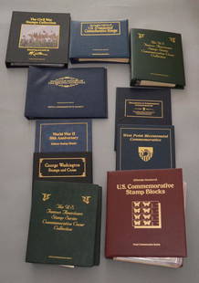
Sold2020Large Lot Of Stamps, Coins, Bills LotIncludes the Civil War stamps collection fixturing artwork by mort Kunstler, The complete collection of US presidential commemorative stamps, fill attic history of original 13 colonies, the US famousSee Sold Price
Sold2020Original WWII U.S. Army Silk Evasion MapsOriginal WWII U.S. Army Silk Evasion Maps - Offered Without Reserve - There is NO ESTIMATE on this item. - Vintage Original WWII U.S. Army Silk Evasion Maps for Aviators Depicting Central FranceSee Sold Price
Sold2023Rare 19thc Census Map, U.S. Agricultural ProductionExtremely rare, original 1876 atlas map of the United States Agriculture Production - five agricultural maps (in inset form) of the production of wheat, hay, corn, cotton and tobacco. Each map distingSee Sold Price
Sold2024[AMERICAN NATIONAL PARKS]. North Half Shasta National Fores...[AMERICAN NATIONAL PARKS]. North Half Shasta National Forest. Recreation Map. U.S. Department of Agriculture, 1916. 30 x 50”. Outlined in several colors. Original folds, some soiling to pamphletSee Sold Price
Sold2016Harcus, William (Editor). South Australia: Its History,Harcus, William (Editor). South Australia: Its History, Resources, and Productions. Illustrated from photographs taken in the Colony. Octavo, wood-engraved plates, without maps, original green cloth oSee Sold Price
Sold2020Map of U.S., 1846*** START PRICE IS THE RESERVE *** [America] HAVEN & EMMERSON. Map of the United States and Mexico Including Oregon, Texas and the Californias. Engraved map with original hand color. New York, 1846. 1See Sold Price
Sold2023Laurie & Whittle Map of the Southern British Colonies of AmericaLAURIE, Robert (1755-1836), and WHITTLE, James (1757-1818). A New and General Map of the Southern Dominions belonging to the United States of America... Engraved map with original hand color in outlinSee Sold Price
Sold2020Johnston Map of U.S. 1844*** START PRICE IS THE RESERVE *** [America] JOHNSTON, Alexander Keith (1804-1871). United States and Texas. Lithograph with original color. London, 1844. 21 1/8" x 26 1/8" sheet. Comparable: Old WorlSee Sold Price
Sold2019MAP - Eastern US. AnonymousColonial Eastern United States. Anonymous, An Accurate Map of the English Colonies in North America Bordering on the River Ohio, 1754 (published). Hand Color. This unusual map of the colonies spans frSee Sold Price
Sold20231889 c. McLoughlin World Map Puzzle and verso is a US Capitol Puzzle -- A New Dissected Map of theTitle: 1889 c. McLoughlin World Map Puzzle and verso is a US Capitol Puzzle -- A New Dissected Map of the World with a Picture Puzzle of the Capitol Cartographer: McLoughlin Bros. Year / Place: 1889 cSee Sold Price
Sold2017Radefeld: Antique Map of U.S. Free & Slave States, 1849Map: Nord-Americanische Freistaaten 1849 Cartographer: Bibliographischen Instituts. / Radefeld Place & Date: Hildburghausen / 1849/1857 Size: 15" x 11 3/8" Condition: original outline color; overall aSee Sold Price
Sold2019Pictorial map of US Sports Records through 1935 --Title/Content of Map: Pictorial map of US Sports Records through 1935 -- Gunther's Map of Sports Records Date: Later print of original 1935, Baltimore Cartographer: Gunther's Brewing Co. Size: 17 x 23See Sold Price
Sold2018DISSECTED MAP OF US PUZZLEMcLoughlin Bros- litho paper on cardboard and wood; original box; complete; Box 8 1/2"x 12"; G-VGSee Sold Price
Sold2021Tallis, John (Pub) 1852 Map. Cape Colony, South AfricaSteel Engraved Map with Original Outline Hand Color Published 1852-56 by John Tallis, London for "The Universal Pronouncing Dictionary" by Thomas Wright. Drawn & Engraved by John Rapkin. Centre fold aSee Sold Price
17 hrs LeftJasper52North-west Europe. Nordic Countries. British Isles Scandinavia. THOMSON 1830 map$100
17 hrs LeftJasper52North-west Europe. Nordic Countries. British Isles Scandinavia. THOMSON 1817 map$120
17 hrs LeftJasper52The Baltic or East Sea, including Gulfs of Botnia & Finland FADEN/NEALE 1803 map$160
May 30NY Elizabeth FIRST US EDITION OF 1869 MALAY ARCHIPELAGO BY A.WALLACE, ANTIQUE ILLUSTRATED WITH MAPS$50(1 bid)
Jun 07Freeman's | HindmanGODMAN, Frederick DuCane and Osbert SALVIN, editors. -- MAUDSLEY, A. P. Biologia$1,000
3 days LeftActivity AuctionsAntique 1787 French Maritime Hydrography Map Eastern Coast United States M Bonne$150
May 25Eagles Corps International LLCLot of original Us Air FOrce Airlift Command C-141 Select Lead Crew patches.$5(1 bid)
May 25Cain Modern AuctionsDouble Sided U.S. Map by Rand McNally, Illustrated & Equal Area Projection$75
7 days LeftJasper521892 Black Map of US New England to New York, Pennsylvania, New Jersey and Canadian Maritimes plus$85


![[AMERICAN NATIONAL PARKS]. North Half Shasta National Fores...: [AMERICAN NATIONAL PARKS]. North Half Shasta National Forest. Recreation Map. U.S. Department of Agriculture, 1916. 30 x 50”. Outlined in several colors. Original folds, some soiling to pamphlet](https://p1.liveauctioneers.com/928/312808/167423169_1_x.jpg?height=310&quality=70&version=1702503866)

![Map of U.S., 1846: *** START PRICE IS THE RESERVE *** [America] HAVEN & EMMERSON. Map of the United States and Mexico Including Oregon, Texas and the Californias. Engraved map with original hand color. New York, 1846. 1](https://p1.liveauctioneers.com/1968/163248/82424576_1_x.jpg?height=310&quality=70&version=1583340284)

![Johnston Map of U.S. 1844: *** START PRICE IS THE RESERVE *** [America] JOHNSTON, Alexander Keith (1804-1871). United States and Texas. Lithograph with original color. London, 1844. 21 1/8" x 26 1/8" sheet. Comparable: Old Worl](https://p1.liveauctioneers.com/1968/163248/82424588_1_x.jpg?height=310&quality=70&version=1583340284)


