Sold20211895 North Carolina MapAuthor: Cram Title: 1895 North Carolina Map Medium: Ink on Paper Dimensions: 22.5"X14.5" Description: Map of North Carolina dated 1895. Printed by George Cram for Walker's International Atlas. PublishSee Sold Price
Sold20211886 North Carolina MapAuthor: Cram Title: 1886 North Carolina Map Medium: Ink on Paper Dimenions: 13.5"X11" Description: Map of North Carolina dated 1886. Printed and published by George Cram in Chicago. Key lower left. WiSee Sold Price
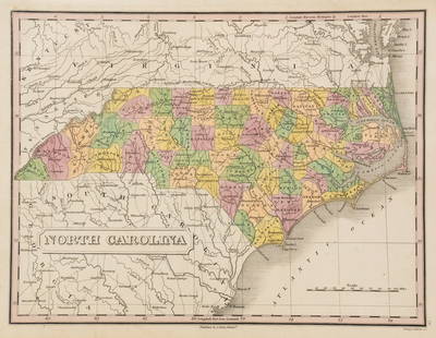
Sold20211885 North Carolina MapAuthor: Watson Title: 1885 North Carolina Map Medium: Ink on Paper Dimensions: 13.5"X11" Map of North Carolina dated 1885. Printed and published by Watson in Chicago. Part of his World Atlas. Key loweSee Sold Price
Sold2021Pender County North Carolina mapPender County North Carolina state highway commission map, US Department of commerce Bureau of public roads state wide highway planning survey from January 1, 1961, size is 19“ x 31“ in very goodSee Sold Price
Sold2021New Hanover county North Carolina mapNew Hanover county North Carolina state highway commission map, US Department of commerce Bureau of public roads statewide highway planning survey from January 1, 1961, size, 19“ x 32“ in very gooSee Sold Price
Sold20211884 North Carolina MapAuthor: Cram Title: 1884 North Carolina Map Medium: Ink on Paper Dimensions: 14"X11" Rail Road and county Map of North Carolina dated 1884. Printed and published by George Cram in Chicago. Part of hisSee Sold Price
Sold2021North Carolina mapNorth Carolina map by Moseley 1733, W.P. Cumming, NC department of archives in history 1966 plate VI 25“ x 32“See Sold Price
Sold2022Three 18th Century North Carolina Mapsengravings on laid paper, all unframed, including: John Reid, The State of North Carolina From the Best Authorities, engraver Benjamin Tanner, New York, circa 1796, sheet 16-1/2 x 19 in.; Matthew CareSee Sold Price
Sold2022Group of Four 19th Century North Carolina Mapsfour maps, engravings on wove paper with hand colored highlights, including: Jean Alexandre Buchon, Carte Geographique, Statistique Et Historique De La Caroline Du Nord, Paris, 1825, unframed; MatthewSee Sold Price
Sold2022Scarce 1st ed. Colton RR map of North CarolinaLovely example of North Carolina map from the first edition of Colton’s Atlas of the World. One of the few mid-19th century maps to show North Carolina independently—it was more often mappSee Sold Price
Sold2021The first actual survey of the state of North CarolinaThe first actual survey of the state of North Carolina map taken by the subleribers, from the North Carolina maps department of archives in history 1966 plate IX 10.25 inches x 38 inchesSee Sold Price
Sold2021The south part of Virginia mapThe south part of Virginia map Comerford 1657 MS by the W P Cumming, North Carolina maps department of archives in history 1966 plate IV 16“ x 20“See Sold Price
Sold20191867 NORTH + SOUTH CAROLINA MAPOriginal antique map of North and South Carolina published by S. Augustus Mitchell, Jr. Includes inset maps of Charleston Harbor in the bottom left and a Plan of Charleston in the bottom right. It feaSee Sold Price
Sold2023Anthony Finley North Carolina Counties MapA Anthony Finley (American, 1784-1834) handcolored engraving depicting the counties within North Carolina and the surrounding areas. Stamped 'Published By A. Finley Phliad.' lower center. Presented inSee Sold Price
Sold20231860 Mitchell Map of Florida, South and North Carolina -- County Map of Florida on page with Map ofTitle: 1860 Mitchell Map of Florida, South and North Carolina -- County Map of Florida on page with Map of South Carolina, on page with County Map of North Carolina Cartographer: S Mitchell Year / PlaSee Sold Price
Sold2018Adolph Dehn (American, 1895-1968) North CarolinaAdolph Dehn (American, 1895-1968) North Carolina Mountaineer. Ink drawing, initialed lower right, dated '19, and titled, unframed 3.25" x 6.5"See Sold Price
Sold20201860 Mitchell Map of Florida, South and North CarolinaTitle/Content of Map: 1860 Mitchell Map of Florida, South and North Carolina -- County Map of Florida on page with Map of South Carolina, on page with County Map of North Carolina Cartographer: S MitcSee Sold Price
Sold20211860 Mitchell Map of Florida, South and North CarolinaTitle: 1860 Mitchell Map of Florida, South and North Carolina -- County Map of Florida on page with Map of South Carolina, on page with County Map of North Carolina Cartographer: S Mitchell Year / PlaSee Sold Price
Sold20181863 Mitchell Map of Florida, South and North CarolinaTitle/Content of Map: 1863 Mitchell Map of Florida, South and North Carolina -- County Map of Florida on page with Map of South Carolina, on page with County Map of North Carolina Date: 1863, PhiladelSee Sold Price
Sold20181860 Mitchell Map of Florida, South and North CarolinaTitle/Content of Map: 1860 Mitchell Map of Florida, South and North Carolina -- County Map of Florida on page with Map of South Carolina, on page with County Map of North Carolina Date Printed: 1860,See Sold Price
Sold20201860 Mitchell Map of Florida, South and North CarolinaTitle/Content of Map: 1860 Mitchell Map of Florida, South and North Carolina -- County Map of Florida on page with Map of South Carolina, on page with County Map of North Carolina Date: 1860, PhiladelSee Sold Price
Sold2021Virginiae item Floridae MapVirginiae item Floridae Description map by the W. P. Coming, North Carolina in maps department of archives in history 1966 plate III Mercator - Hondius 1606 15 1/2“ x 21“See Sold Price
Sold2019North & South Carolina Early MapJohnson's North Carolina and South Carolina. Antique Map. A.J. Johnson, New York, c. 1866-70.. 18" x 26 1/2".See Sold Price
Sold2022Times Atlas 1895 Map. North Polar RegionsLithograph Map Published 1895, London for "The Times Atlas" Centre fold as published. Paper Size: 21.5 x 16 inch (54 x 41cm) Good ConditionSee Sold Price
4 days LeftTrillium Antique Prints & Rare BooksKarl Bodmer - Fox River, Indiana with Carolina Parrots (Extinct) & Bald Eagle. 5$300
4 days LeftTrillium Antique Prints & Rare BooksBrasher - Redbreast & Northern Redbreast Sapsucker. 403$40
3 days LeftMeander Auctions by Andrew Richmond and Hollie DavisPAIR OF PHOTOGRAPHS BY BAYARD WOOTTEN (NORTH CAROLINA, 1876-1959)$150