Sold2023Official Map of Beaverhead County 1901Official Map of Beaverhead County, Montana, compiled from the latest official records by George R. Metlen, county surveyor, civil and mining engineer, Dillon, Montana, 1901. Measures approximately 44See Sold Price
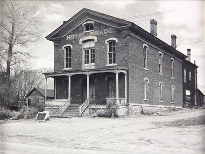
Sold2022Hecla Consolidated Mining Company Archive, c. 1878-1900 [154470]The Hecla Consolidated Mining Company was involved in the mining, smelting, and reduction of gold, silver, copper, and lead in Beaverhead County, Montana. The company was organized in 1877 but was notSee Sold Price
Sold2023Ajax Mining Company 1896 (Beaverhead County, MT)Ajax Mining Company 1896 (Beaverhead County, Montana) seal embosser. Provenance: Montana private collection. If lot is absent of a condition report one may be requested via email. Condition report isSee Sold Price
Sold2023Natural History - Fossil Leaf GroupOligocene Period, circa 34-23 million years B.P. A group of three fossil leaves in matrix. 15 grams total, 59-77 mm (2 3/8 - 3 in.). From Beaverhead County, Montana, U.S.A.Collected between 1930 and 1See Sold Price
Sold20201876 Mitchell Map of Colorado, Wyoming, Dakotas,Title/Content of Map: 1876 Mitchell Map of Colorado, Wyoming, Dakotas, Nebraska, and Montana -- County Map of Colorado, Wyoming, Dakota, Montana Date: 1876 Philadelphia Cartographer: S Mitchell Size:See Sold Price
Sold2023Railroad and County Map of Montana.Publication Date: 1887 Title: Railroad and County Map of Montana. Cartographer: CRAM, GEORGE F. Publisher: A.A. Grant Height: 21.1 Width: 22.1 Detailed state map with railroads marked. Some topographySee Sold Price
Sold2021Montana Map Sweet Grass County 1905Yellowstone Forest Preserve, Framed, 36" x 51", map has some water damage in the upper section.See Sold Price
Sold2017LARGE SELCECTION OF RECREATIONAL & CITY MAPSLARGE SELCECTION OF RECREATIONAL & CITY MAPS - CALIFORNIA - MONTANA - TRINITY COUNTY - SHASTA LAKE - IDAHO & MANY MORESee Sold Price
Sold2020County and Township Map of Montana, Idaho and WyomingTitle: County and Township Map of Montana, Idaho and Wyoming Publication Date: c1886 Cartographer: MITCHELL, SAMUEL AUGUSTUS (JR.)/WM. M. BRADLEY & BRO. Publisher: WM. BRADLEY & BRO. Brief DescriptionSee Sold Price
Sold2018County and Township Map of Montana Idaho and WyomingReserve Reduced! Title: County and Township Map of Montana Idaho and Wyoming Publication Date: 1881 Cartographer: MITCHELL, SAMUEL AUGUSTUS Publisher: S.AUG. MITCHELL Size: 14.6X21.5 Railroads shown.See Sold Price
Sold2022(WEST--KANSAS.) Letters and map from early Nemaha County.(WEST--KANSAS.) Letters and map from early Nemaha County. Printed map, 27½ x 19½ inches; toning, partial separations at folds, other minor wear. with 11 related letters to the Sage family daSee Sold Price
Sold2023Map of Kan. Neb. Col. Dak. Et al, Mitchell 1872Great mid-continent map; shows Montana with just 2 counties, Wyoming with only 5 counties and early images of Colorado and Dakota. Shows the Little Big Horn area just four years before General CusterSee Sold Price
Sold2020Photographs, John Vachon(lot of 7) John Vachon (American, 1914-1975), Montana series- Judith Gap, Jackson, Bannack, McCone County, Beaverhead County, 1942, gelatin silver prints, later printings, each unsigned, sight: 2.75"hSee Sold Price
Sold2021Map of Territory of MontanaMap of Territory of Montana Color Map Dated: 19th century Dimensions: 10 x 6 1/2" Condition Report Good. Text on verso. Subject ReferencSee Sold Price
Sold20221890 Kessler Brewery/American Publishing Birds Eye View Map of Helena Montana -- Perspective Map ofTitle: 1890 Kessler Brewery/American Publishing Birds Eye View Map of Helena Montana -- Perspective Map of the City of Helena, Mont. Capital of State, County Seat of Lewis & Clarke Co. 1890 CartographSee Sold Price
Sold20201887 Map of MontanaAuthor: Watson Title: 1887 Map of Montana Medium: Ink on PaperDimensions: 21.5"X14.5" Map of Montana, dated 1887 engraved for Watson's General Atlas. Double folio map. Color coded for counties. Key loSee Sold Price
Sold2017Rand McNally Pocket Map & Shippers Guide of Alaska 1912Map: Rand, McNally & Co.'S Indexed County and Township Pocket Map And Shippers' Guide of Alaska Publication Date: 1912 Author: RAND, MCNALLY & COMPANY, RAND, MCNALLY & CO. Publisher: RAND, MCNALLY & CSee Sold Price
Sold2022Scarce map of NW territories, Hardesty 1875Scarce regional map of the Wyoming Territory, Montana Territory, Dakota Territory and Nebraska, colored by counties and showing towns, mountains, rivers, railroads, etc. One of the few maps to show WySee Sold Price
Sold20231912 Topographical Map of Kauai, Hawaii -- Topographic Map of the Island of Kauai, Kauai County,Title: 1912 Topographical Map of Kauai, Hawaii -- Topographic Map of the Island of Kauai, Kauai County, Hawaii Cartographer: U.S. Geological Survey Year / Place: 1912 Map Dimension (in.): 29.8 X 38.6See Sold Price
Sold2024Rand McNally/Santa Fe Railroad Map of Iowa-1912This is a Rand McNally/Atchison Topeka and Santa Fe Railroad Map of Iowa dated 1912. One does not usually associate the ATSF with Iowa, but it did pass through Lee County, in the southeast corner of tSee Sold Price
Sold2017NEW CENTURY ATLAS OF COUNTIES OF THE STATE OF NEW YORK,NEW CENTURY ATLAS OF COUNTIES OF THE STATE OF NEW YORK, EVENTS PUB. CO., 1912; (42) COLORED MAPS. 26 X 20" (IMPERFECTIONS)See Sold Price
Sold2019LARGE 1912 MAP, CITY OF AUSTIN, TEXAS, 73" x 44"Large faded unframed map, "Tobins Updated Map of the City of Austin, Mar. 1912", showing downtown blocks, the capitol building, East Avenue that became I35 and neighborhoods, 73.75"h, 44.5"w Start PriSee Sold Price
Sold20244" Clovis. Liberty County, Montana. Black Chert. Putty COA4" Clovis. Liberty County, Montana. Black Chert. Ex Matt Conway and Ron Comer. Putty COASee Sold Price
Sold2021Litchfield County Map Hopkins and Clark 1869Litchfield County Map Hopkins and Clark 1869 54.5"x64"hSee Sold Price
2 days LeftJasper52New Map of That Portion of North America Exhibiting the United States and Territories...Mexico...$360
3 days LeftMichael Scarola Rare and Used BooksMilitary Wagon-Road In Wyoming And Montana Territories With Map Of Military Reconnaissance 1873-4$100
May 16Potter & Potter AuctionsMcCARTY, Lea (1905 – 1960). Sonoma County / Its Highlights ...$100(1 bid)
7 hrs LeftRapid Estate Liquidators and Auction GalleryFramed Collection Engravings & A Map From The Excursions In The County Of Sussex Published In 1822$50


![Hecla Consolidated Mining Company Archive, c. 1878-1900 [154470]: The Hecla Consolidated Mining Company was involved in the mining, smelting, and reduction of gold, silver, copper, and lead in Beaverhead County, Montana. The company was organized in 1877 but was not](https://p1.liveauctioneers.com/2699/258191/134291013_1_x.jpg?height=310&quality=70&version=1660351799)