Sold202216th / 18th C. European Maps of New Spain (2)**Originally Listed At $300** Cartographer: Gerard Mercator. "Hispaniae Novae Nova Descriptio" Published by I.E. Cloppenburgh, Amsterdam, 1632. AND Stieler's "Mexico Und Centro-America …" Gotha, 182See Sold Price
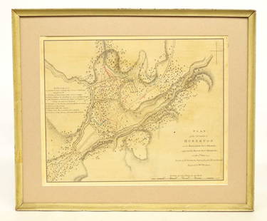
Sold202018th c. Battle Map18th c. Battle map "PLAN / of the ACTION of / HUBERTON...July 1777". Sight 11" x 13 1/2".See Sold Price
Sold2017LOT (6) ASSORTED ENGRAVED MILITARY MAPS INCLUDING FT.LOT (6) ASSORTED ENGRAVED MILITARY MAPS INCLUDING FT. ST. PHILIP AND ENVIRONS, 18TH CENTURY, 14 1/2 X 9"; (3) BATTLE PLANS INCLUDING DEFRIBOURG, 1644; DETURCKEIM, 1674; D'ENSHEIM, 1674; ALL 10 X 15";See Sold Price
Sold2019(2) 18TH C. MAPSNetherlands. Dimensions: (Frame) H 32.25" x W 36", (Sight) H 22.5" x W 27" Condition: Wear consistent with age and handling. Toning, marks, and creases.See Sold Price
Sold20242 18th C. Road Maps: London to Carlisle (14 1/2" x 17 1/2") & Bristol to Exeter, 6 1/2"2 18th C. Road Maps: London to Carlisle (14 1/2" x 17 1/2") & Bristol to Exeter, 6 1/2"See Sold Price
Sold2022(2) 18th c. road maps, London-Norwich, etc.Two hand colored maps of roads from London to Norwich, England, and from Shrewsbury to Holywell, England. A printed description in an attached envelope on the back of one states that they were made bySee Sold Price
Sold20201761 MAP OF NORTH AMERICA BY ROCQUE18th century map GENERAL MAP OF NORTH AMERICA 1754-1761 by John Rocque, London by A. Drury, 2 part map, 35.5 x 36 inches, good condition.See Sold Price
Sold2023Map Of America & West Indies Principal Harbors Eman BowenDraughts and Plans of Principal Towns and Harbours belonging to the English, French and Spaniards by Eman Bowen 15 3/4 x 18 1/2 (sheet) 18th century framed map.See Sold Price
Sold20222 Framed 18th C. Faden Maps - Greece & Denmark**Originally Listed At $200** Cartographer: William Faden (British, 1749-1836). Engraver: William Palmer (British, 1735-1812). "Graecie Antiquae et Aegaei Maris Tabula" Published by William Faden JanuSee Sold Price
Sold202118TH C. (1755) MAP OF N.Y. , PENSYLVANIA & NEW ENGLANDFRAMED 18TH C. (DATED 1755) 2 PART MAP "A MAP OF THE PROVINCE OF NEW YORK, WITH PART OF PENSILVANIA AND NEW ENGLAND / FROM AN ACTUAL SURVEY BY CAPTAIN MONTRESOR, ENGINEER 1755" - FRAME 59 1/4" X 39",See Sold Price
Sold202218th & 19th C. MAPS OF ASIA (3 MAPS)Includes: 2 maps by John Tallis & Co. London / New York, ca. 1850, both matted and framed, including: (1) MAP OF ASIA. Hand colored engraved map. 5 hand colored vignettes. H. 10.25", W. 12.75"; (2) MASee Sold Price
Sold2024Two (2) Antique 18th C. Copper Engraved Framed Maps - America & EuropeTwo (2) antique 18th C. copper engraved framed maps. One of Amerique and other titled Carte d'Europe. Both framed under glass. Frame Size: 13.5H x 14.5W (each)See Sold Price
Sold202218th C. MAPS OF NORTH AMERICA & CARIBBEAN (2 MAPS)Includes: Brian de la Tour, Louis. L'AMERIQUE DRESSEE POUR L'ETUDE DE LA GEOGRAPHIE (Paris, 1764).Copperplate engraved map of North and South America. Hand colored. Matted and framed. H. 11", W. 12" BSee Sold Price
Sold2021Map of City and Harbour of MacauA Plan of the City and Harbour of Macao" engraved by B. Baker, Islington 27" x 20 1/2" (sight) hand-colored engraved map 18th century framed- 32 1/2" x 40See Sold Price
Sold2023Jean Janvier - 18th Century Map of the AmericasJean Janvier (fl. 1746 - 1776), L'Amerique divisee Par Grands Etats..., Paris, 1783, engraving on laid paper with hand colored highlights, sight 13 x 18-1/2 in.; wood frame, 21-3/8 x 27 in. ProvenanceSee Sold Price
Sold2015Period 18th Century Map of Switzerland.Period 18th century map of Switzerland. By A. Rouvier. 21" x 27-1/2" plate size. Published by John Rocque 1760, London. Size 29 -1/2" x 21 -1/4".See Sold Price
Sold202018th Century Map of Caribbean: faded, in 2 parts, 11 x18th Century Map of Caribbean: faded, in 2 parts, 11 x 14-1/2 inchesSee Sold Price
Sold2021Authentic Early / 18th C Maps(1) South America Bolivia and Peru Sheet VI Engraved by J. and C. Walker; (2) Rand McNally and Co Atlas of the World Map of Bolivia, Ecuador and Peru page 173; (3) Andre Sculpt's Imperii Romani DistraSee Sold Price
Sold2023Four 18th Century Celestial MapsAn assembled collection of four antique Celestial maps to include 1) "Theoria Cometarum, in qua Praecipua Eorum Phaenomena", Atlas Coelestis 1742, sight size 19.5" x 22.5". Note staining, toning. 2) "See Sold Price
Sold201718th Century French Map of North AmericaL’Amerique Septentrionale. Daniel de la Feuille (1640-1709). Engraved map with hand color in full. Amsterdam, 1702 or 1706. 6 x 8 inches visible, 13 x 14 1/2 inches framed. Nicely colored early 18thSee Sold Price
Sold2017Janvier Map L'AmeriqueL'Amerique divisée en ses principaux Etats...Janvier Sr. (18th. century). Engraved map with original hand color in full. Paris, 1760. 22 x 28 1/2 inches sheet.See Sold Price
Sold2019Map of America and West IndiesDraughts and Plans of Principal Towns and Harbours Eman Bowen 15 3/4" x 18 1/2" (sheet) 18th centurySee Sold Price
1 day LeftJ Solomon & Mackintosh Auction ArtsRare 18th century English armchair original early tapestry Thomas Chippendale$1,000
1 day LeftJ Solomon & Mackintosh Auction ArtsFine 18th century Italian Santos shrine and Christ Child santos$700
19 hrs LeftNY Elizabeth 1741 AN ANCIENT HISTORY OF THE CONQUEST OF MEXICO SPANISH ILLUSTRATED FOLIO$150(2 bids)
4 days LeftJasper52A Chart of the Sea Coasts of Algrave [Algarve] & Andalusia MOUNT & PAGE 1758 map$380
19 hrs LeftFreeman's | HindmanTwo Wrought Iron Belt Clasps, French and Other, 17th / 18th Century$150
5 days LeftLeland LittleRobert de Vaugondy's 18th-Century French Map of North America's Eastern Seaboard$50
Oct 27Schilb Antiquarian Rare Books1764 OTTOMAN WARS Turkey Murad I Battle of Vienna MAP Hapsburgs Islam Muslim$36(4 bids)
Oct 26Sofe Design AuctionsRare Map with the marking of Sea of Korea/East Sea by Jacques Nicolas Bellin ? 18th Century.$100
4 days LeftJasper521770 French engraving map of Bonne,Rigobert Arabie. Mer Rouge et Golfe Persique$60
7 days LeftBrunk AuctionsA New England Queen Anne Figured Walnut Veneered High Chest of Drawers$3,000
19 hrs LeftNY Elizabeth 1706 ILLUSTRATED VINTAGE RARE F. PIZARRO D. ALMAGRO CONQUEST OF PERU AND PANAMA$50
Oct 05Ripley Auctions18th century Map of the Americas by Jean Baptiste Louis Clouet (c. 1730-1790), copper, engraving on$100
4 days LeftJasper52Isles Britanniques… L'Angleterre, L'Ecosse & L'Irlande. Philippe Pretot 1767 map$300


![A Chart of the Sea Coasts of Algrave [Algarve] & Andalusia MOUNT & PAGE 1758 map (1 of 1)](https://p1.liveauctioneers.com/5584/343699/186669025_1_x.jpg?height=282&quality=70&version=1726603887)


