Sold20162 Early Maps of PennsylvaniaDESCRIPTION: Two early maps of Pennsylvania. Includes: 1) 1805 handcolored engraved map by John Carey in two parts. 17" x 21-1/4". Hinged at center. Small pinhole to York County. Light edge toning. CoSee Sold Price
Sold2017LOT (3) EARLY POCKET BOOK MAPS C.1830'sLOT (3) EARLY POCKET BOOK MAPS INCL. H/C STATE OF NEW YORK BY HUMPHREY PHELPS,1833, 16" X 21", STATE OF NEW JERSEY BY J. LOW, C. 1830, 10 1/2" X 7 1/2", STATE OF PENNSYLVANIA BY A. FINLEY, C. 1830, 9"See Sold Price
Sold2017Map LotLot (2) early mounted maps. Includes New York (30 1/2" x 22 1/2") and County of Essex (30 1/2" x 22 1/2").See Sold Price
Sold2020Guide to the Appalachian Trail In PennsylvaniaGuide to the Appalachian Trail in Pennsylvania Includes all separate maps. [4 maps (2 combined on one)] Dated: 1970 Publisher: Keystone Trails Association</See Sold Price
Sold2021(2) EARLY US COLONIAL CURRENCY NOTES - PENN & NJall pre-Revolutionary War, includes a Pennsylvania Six Pence note dated 1772 and signed by John Morton, signer of the Declaration of Independence, PMG graded 12 (Fine), and a New Jersey 30 Shilling noSee Sold Price
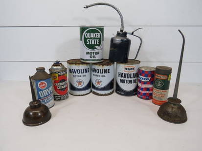
Sold2021Texaco, Quaker State Oil Cans & Oilers (10)Includes a Quaker State Empty oil can -3 Texaco Havoline empty oil cans -2 Early Oilers -1 Grease can -Perma-Tite Cold patch tin w/ contents -Steed Conditioner can w/ contents -Dry gaSee Sold Price
Sold20232 Early 1900s Photo Albums Incl. Western US, Tour Of Europe & WWI RuinsDESCRIPTION: Softcover leather photo albums of Western views in the United States. Album 1 includes Silver City, and Albuquerque, New Mexico, along with Los Angeles and San Gabriel, California. AlbumSee Sold Price
Sold2020Map of the States of Pennsylvania and New JerseyMap of the States of Pennsylvania and New Jersey by I.T. Hinton & Simpkin & Marshall and engraved by Fenner Sears & Co., March 15, 1832. It is a fantastic early British publication. Hand colored. Is iSee Sold Price
Sold20232 Early 1900s American Cavalry Photographs2 photographs of United States cavalry soldiers. Includes 9-3/4" high x 11-3/4" wide photograph of men and horses besides a monument, and a 15" high x 23-1/4" wide photograph of soldiers on horsebackSee Sold Price
Sold20239 1889 Franklin & Roe Harrisburg BlueprintsBlueprints includes (1) Map of 7th & 8th wards. Includes Sunshine Park & Allison Hill areas; Harrisburg Cemetery; Pennsylvania State Arsenal; and more. Streets include Reily St.; Walnut St.; PennsylvaSee Sold Price
Sold20161940’s-1960’s Canadian & U.S. Road MapsLot of 19 assorted 1940’s-1960’s Canadian & U.S. recreational, sightseeing & state highway system maps includes: Alabama highway, Pennsylvania highway, Maine highway, New Jersey highway, New YorkSee Sold Price
Sold2021Carolina’s with parts of Georgia and Virginia, earlyTitle: Carolina’s with parts of Georgia and Virginia, early map of southern United States, by Bonne/ Raynal 1780 Date/Period: 1780 Materials: Copperplate engraved Size: 13 1/2 x 9 3/4'' Shows aSee Sold Price
Sold2021Northern United States, NY, NJ, MD, PA and the NewTitle: Northern United States, NY, NJ, MD, PA and the New England states, By Bonne/ Raynal 1780 Date/Period: 1780 Materials: Copperplate engraved Size: 13 1/2 x 9 3/4'' Early map of a recognized indepSee Sold Price
Sold2021(4) RYUIJIE DOUGLAS PHOTOGRAPHSRyuijie Douglas (b. 1950) Collection of (4) black and white photographs. Each pencil signed. Matted, unframed. Photographs include Early Morning - Garrapata State Park, Dune, Oriental Center # 2, andSee Sold Price
Sold2020Scarce 1934 Lackawanna RR booklet, w/mapMountain and Lake Resorts, Along the Lackawanna Railroad. Scarce and collectible 48-page booklet showing resort areas in eastern Pennsylvania and northern New Jersey. Includes full-color 2-page map tiSee Sold Price
Sold2022Early map of the large size Texas state, first to show Dallas. 1846 by MitchellTitle: Early map of the large size Texas state, first to show Dallas. 1846 by Mitchell Date/Period: 1846 Materials: Hand colored engraved Size: 11 1/2 x9" Very important map shows Texas as it first joSee Sold Price
Sold20212 Pyrography Leather MapsTwo Pyrography Leather Maps, in scroll form with wood rod ends, both with pyrography and polychromed designs, includes: world and regional maps, early 20th C, 21" x 16", 21" x 18". CONDITION: Modest wSee Sold Price
Sold2020Early United States Roll-Up MapEarly United States roll-up map. Published by J. H. Colton / New York / 1853. 44 1/2" x 36".See Sold Price
Sold20161862 Walling Pennsylvania Topographical Wall MapDESCRIPTION: 1862 Topographical Map of the State of Pennsylvania Drawn to the Actual Surveys by H.F. Walling. Published by Smith, Palmer & Co. Includes the following inset maps: Climatological Map bySee Sold Price
Sold2022Assortment of Early Maps, Israel and the Middle EastAssortment of Early Maps, Israel and the Middle East, includes: 1. The Land of Israel: Settlement Map and Road Map, published by Am Oved, 1945, 2. Map of the middle east published by John Bartholomew@See Sold Price
Sold202219TH C. RAILROAD MAP PRINTS - LOT OF 219TH C. RAILROAD MAP PRINTS - LOT OF 2 Lot of 2 railroad map prints, circa 19th century, includes: 1857 Map of the Railroads of the state of New York, drawn by David Vaughan, Lith. C. Van BenthuSee Sold Price
Sold20221853 map of the South, Burgess/SmithInteresting map of four southern states. Includes population and other details. Shows towns, counties, roads, railroads, mountains, rivers, islands, bays. Early primitive Florida treatment, prior to tSee Sold Price
Sold20181839 Mitchell Map of the United StatesTitle/Content of Map: 1839 Mitchell Map of the United States -- No. 5 Map of the United States Date Printed: 1839, Philadelphia Cartographer: S Mitchell Size: 10.2 x 16.7 in. This early US map has terSee Sold Price
3 days LeftJasper521795 Lewis Map of Maryland -- The State of Maryland, from the best Authorities$360
Jun 12Dan Morphy AuctionsINDIAN TERRITORY - DEPARTMENT OF THE INTERIOR GENERAL LAND OFFICE, C.1883$100
JG AutographsJohn Gorham Palfrey - American Clergyman & U.S. Representative of Massachusetts - Autographed Letter$10(1 bid)
5 days LeftThe Bidder AuctionsThe Land of Israel Wanderers' Association Library - Israel - from Dan to Eilat - 2 map folders -$30
Jun 08Early American History Auctions1777 JOHN NIXON Signed Oath, Gave the First Declaration of Independence Public Reading, July 8, 1776$800
6 days LeftFreeman's | Hindman[CIVIL WAR - GETTYSBURG]. A group of 2 CDVs, incl. Wesley Merritt and Thomas Devin.$250


![Guide to the Appalachian Trail In Pennsylvania: Guide to the Appalachian Trail in Pennsylvania Includes all separate maps. [4 maps (2 combined on one)] Dated: 1970 Publisher: Keystone Trails Association</](https://p1.liveauctioneers.com/5614/177396/89304803_1_x.jpg?height=310&quality=70&version=1598306092)


![[CIVIL WAR - GETTYSBURG]. A group of 2 CDVs, incl. Wesley Merritt and Thomas Devin. (1 of 2)](https://p1.liveauctioneers.com/197/329785/177758289_1_x.jpg?height=282&quality=70&version=1715625218)