Sold20164 maps: Colonial US, Maryland, DC, Railroads[Railroads/MD/DC] 4 Maps. ++ J.G. Langdon. MAP OF THE DISTRICT OF COLUMBIA 1901… FOR THE PREPARATION OF A PLAN FOR THE IMPROVEMENT OF THE PARK SYSTEM OF THE DISTRICT OF COLUMBIA. NO. D-99. Balt: A.See Sold Price
Sold2020Antique (1895) Rand McNally Pocket Map of Maryland and4 1/4 x 6 1/2 inches; aÊbeautifully maintained, comprehensive representation showing the entire railroad system throughout Maryland, D.C. and DelawareSee Sold Price
Sold2023FRAMED MAP OF US MILITARY RAILROADSMRKD. 1866, LITHO BY J. BIEN CO. NY. TOTAL FRAMED SIZE 32 1/4" X 42 1/4". Terms: PLEASE READ CAREFULLY - Terms for Purchasing and Shipping of Auction Items. Please read carefully before bidding. All pSee Sold Price
Sold201510 Maps: New York street grid, views, US, MD[New York/Maryland/US] 10 Maps. 8 1/8 x 9 3/4 in. to 17 7/8 x 27 1/2 in. Sold with all faults. ++ MAP OF THE CITY OF NEW-YORK 1852. Folding map from an annual edition of Valentine’s Manual. ++ PARTSee Sold Price
Sold20201757 Bellin Map of Colonial Virginia and Maryland --Title/Content of Map: 1757 Bellin Map of Colonial Virginia and Maryland -- Carte de la Baye de Chesapeack et Pays Voisins Cartographer: J Bellin Year/Place: 1758 c., Paris Size: 7.5 X 11.4 in. This isSee Sold Price
Sold2016Map of Maryland, Delaware and Washington, DC, 1796Original engraving from Morse’s Universal Geography published by Thomas & Andrews, Boston, 1796. Dimensions: 12 3/4” x 15” No Reserve This item ships from Ocean View, DE.See Sold Price
Sold2022AUTHENTIC DATED 1770 STATE OF MARYLAND $4 COLONIAL NOTEAUTHENTIC DATED 1770 STATE OF MARYLAND $4 COLONIAL NOTE. THIS IS AN AUTHENTIC PIECE OF COLONIAL CURRENCY FROM THE 1700'S. THESE EARLY U.S. CURRENCY PIECES FROM THE COLONIES THAT WOULD MAKE UP OUR STATSee Sold Price
Sold2022VINTAGE NORTH EASTERN US & FRENCH ROAD MAPSVINTAGE NORTH EASTERN US & FRENCH ROAD MAPS Road maps of the eastern seaboard of PA, NY, D.C., VA, MD, and NJ by AAA and Exxon. Also included are five Michelin maps of France.See Sold Price
Sold2017Florida Lithograph MapU.S. Coast Survey Sketch F Showing the Progress of the Survey in Section V. A.D. Bache (1806-1867). Lithographed map. Washington, D.C., 1855. 23 x 16 1/2 inches visible, 27 1/4 x 21 1/2 inches framedSee Sold Price
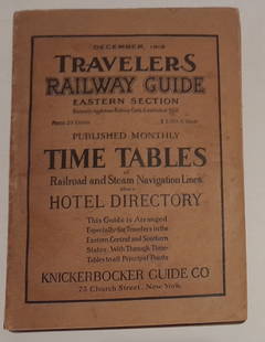
Sold20241915 Traveler's Guide Eastern US. A 344 page bookA 5 3/4" by 8" soft cover book with railroad timetables and other travel information: hotel ads, city, state maps, etc. Paper is supple and not pulpy.See Sold Price
Sold2023An assortment of 4 American dollar bills of the railway companiesAn assortment of 4 U.S. railroad company dollar bills, including: Mississippi & Alabama Railroad Company $1000 bill, Southern Confederacy $50 bill, Richmond, Virginia, 1861, Bank of Chicago $2 bilSee Sold Price
Sold2020The World Around Us #4 RailroadsNo Reserve! The World Around Us #4 Railroads. VG+ Shipping: Domestic: Flat-rate of $9.99 for 1 to 8 items; Flat-rate of $19.99 for 9 items or more to anywhere within the contiguous U.S. International:See Sold Price
Sold20221879 Powell Map of US with Railroad Grants -- Map of the United States Exhibiting the Grants ofTitle: 1879 Powell Map of US with Railroad Grants -- Map of the United States Exhibiting the Grants of Lands Made by the General Government to Aid the Construction of Railroads and Wagon Roads. CartogSee Sold Price
Sold2022FRAMED MAP OF DELAWARE & MARYLAND (& DC)"Johnson's Delaware and Maryland" by A. J. Johnson, 1860, published in NYC. Hand colored engraving. Includes vignette map of "Washington City", giving an 1850 population of 29,815 Whites, 8,073 Free CSee Sold Price
Sold2021Postwar Lionel O Gauge 950 U.S. Railroad Map, inPostwar Lionel O Gauge 950 U.S. Railroad Map, in Original Tube, with the 950 U.S. railroad map and tube in C9.See Sold Price
Sold2023Maps of the US and World4 Maps of the US and World, Missouri Pacific Lines, Boy Scouts, Flying AmbassadorsLargest 34.75" H x 46.25" WProperty from the estate of Seymour Stein (1942 - 2023).See Sold Price
Sold20184 19th Century Maps The World, North/South U.S.4 19th Century Maps The World, North South U.S.. 4 Maps of The World, Political Map of The Southern Division of the U.S., The Northern Division of the U.S. and Political Map of South America and AfricSee Sold Price
Sold2017Mitchell: Railroad & Steamboat Map of the US, 1887Map: 1887 Mitchell Railroad and Steamboat Map of the US -- Railroad Map of the United States, Showing the through Lines of Communication from the Atlantic to the Pacific. Together with the Various SteSee Sold Price
Sold20191886 Mitchell/Bradley Railroad and Steamboat Map of theTitle: 1886 Mitchell/Bradley Railroad and Steamboat Map of the US -- Railroad Map of the United States Together with the Various Steamship Lines along the Seaboard Date: 1886, Philadelphia CartographeSee Sold Price
Sold20181840 c. Collins Map of the US with Railroads -- UnitedTitle/Content of Map: 1840 c. Collins Map of the US with Railroads -- United States Date: 1840 c., London Cartographer: H Collins Size: 11.2 x 9 in. This is a very interesting map of the US east of TeSee Sold Price
Sold2022US DEPARTMENT OF DEFENSE. KOREAN WAR MAPS (1950-1953)US DEPARTMENT OF DEFENSE. KOREAN WAR MAPS (1950-1953) INCLUDING SANGYONG, MAJON-NI, AND YANGHOP-TONG. Washington DC: US Army Map Service. Seven maps from the country, of Sangyong (17), Majon-Ni (8), YSee Sold Price
Sold2022US DEPARTMENT OF DEFENSEUS DEPARTMENT OF DEFENSE. KOREAN WAR MAPS (1950-1953) YONCH'ON, CH'ORWON AND OTHERS. Washington DC: US Army Map Service. Seven maps from the country, of Yonch'on (7), Ch'orwon (7), Tuksom (9), UijongbSee Sold Price
Sold20211883 Donaldson US Map of Subsidized Railroads West ofTitle: 1883 Donaldson US Map of Subsidized Railroads West of Missouri -- Map of the Railroads in Whole or in Part West, North or South of the Missouri River, to which the United States Have Granted AnSee Sold Price
Sold20211855 Colton Map of Maryland, Delaware and Washington DCTitle: 1855 Colton Map of Maryland, Delaware and Washington DC -- Delaware and Maryland Cartographer: J Colton Year / Place: 1855, New York Map Dimension (in.): 11.8 X 15.8 in. This is a very nice mapSee Sold Price
6 days LeftJasper521884 Rand McNally Map of US Railroad System -- Map Exhibiting the Several Pacific Railroads Prepared$140
6 days LeftJasper521896 Cram Map of Virginia, West Virginia, Maryland and Delaware -- Railroad and County Map of$40
14 hrs LeftMynt AuctionsColonial by Tiffany and Co Sterling Silver Salad Fork 3-Tine 2-Hole 6 3/4"$10
1097 Lots AwayMynt AuctionsColonial by Tiffany and Co Sterling Silver Olive Spoon Pierced Custom 5 3/4"$10
600 Lots AwayMynt AuctionsColonial by Gorham Sterling Silver Salad Serving Fork 3-Tine FH AS 7 3/4"$10
1 day LeftMynt AuctionsColonial Theme by Lunt Sterling Silver Fish Knife Individual HHWS Custom 8 1/4"$10
1 day LeftMynt AuctionsColonial Theme by Lunt Sterling Silver Horseradish Scoop Custom Made 5 3/4"$10
1 day LeftMynt AuctionsColonial by Gorham Sterling Silver Grapefruit Spoon Fluted Custom Made 5 3/4"$10
2 days LeftMynt AuctionsGrand Colonial by Wallace Sterling Silver Fish Knife Individual Custom 8 1/4"$10
5 days LeftMynt AuctionsOld Colonial by Towle Sterling Silver Fish Knife Flat Handle All Sterling 7 1/4"$10
942 Lots AwayMynt AuctionsOld Colonial by Towle Sterling Silver Ice Cream Server Gold-Washed 10 1/4"$10
6 hrs LeftMynt AuctionsFrench Colonial by Blackinton Sterling Silver Butter Spreader Flat Handle 5 3/4"$10
14 hrs LeftMynt AuctionsOld Colonial by Towle Sterling Silver Dinner Knife Old French Stainless 9 3/4"$10


![4 maps: Colonial US, Maryland, DC, Railroads: [Railroads/MD/DC] 4 Maps. ++ J.G. Langdon. MAP OF THE DISTRICT OF COLUMBIA 1901… FOR THE PREPARATION OF A PLAN FOR THE IMPROVEMENT OF THE PARK SYSTEM OF THE DISTRICT OF COLUMBIA. NO. D-99. Balt: A.](https://p1.liveauctioneers.com/179/85723/44107986_1_x.jpg?height=310&quality=70&version=1457208384)


![10 Maps: New York street grid, views, US, MD: [New York/Maryland/US] 10 Maps. 8 1/8 x 9 3/4 in. to 17 7/8 x 27 1/2 in. Sold with all faults. ++ MAP OF THE CITY OF NEW-YORK 1852. Folding map from an annual edition of Valentine’s Manual. ++ PART](https://p1.liveauctioneers.com/179/82189/42599761_1_x.jpg?height=310&quality=70&version=1447864785)