Sold2022French Le Maine hand colored map engraving, central France, by Nicolas Sanson (1600-1667) 15"H xFrench Le Maine hand colored map engraving, central France, by Nicolas Sanson (1600-1667) 15"H x 19"W (image), 23"H x 30 3/4"W (frame)See Sold Price
Sold2021Jean Jolivet Map, FranceGalliae Regni Potentiss", hand colored engraving by Jean Olivet, with text verso. Toning, spotting, tears, pencil marks at the lower right, other wear. 18.5" x 23See Sold Price
Sold2019Antique 1806 Robert de Vaugondy Map of FranceAntique 1806 Robert de Vaugondy Map of France. Antique early 19th century hand colored engraving. Framed and matted. Measures 14.5 x 17 inches.See Sold Price
Sold2016JOHN SPEED (BRITISH, 1552-1629) MAP OF THE WORLDJOHN SPEED (BRITISH, 1552-1629) MAP OF THE WORLD, (UPDATED 6/14/16) hand-colored engraving on laid paper, titled "A New and Accurat Map of the World Drawne according to ye truest Descriptions latest DSee Sold Price
Sold2021ROBERT DE VAUGONDY (France, 1688-1766), Map of NorthROBERT DE VAUGONDYFrance, 1688-1766Map of North America "Amerique Septentrionale, dressee, sur les Relations les plus Modernes des Voyaeurs et Navigateurs". Hand-colored engraving, 18.5"See Sold Price
Sold2019Blaeu Early Map Sedan Northern FranceEarly map: Les Souverainetez de Sedan et de Raucourt. Hand-colored engraving. Blaeu, Amsterdam, 17th Century. 20" x 24".See Sold Price
Sold2023Cary Antique Maps, Western European (4)Set of 4 maps including Europe, France, Netherlands, Portugal. John Cary, London, early 19th C. Hand-colored engravings. Center vertical folds, as issued.See Sold Price
Sold2022c.1859 Map: Dept. De La Charente, by Levasseur.Handsomely framed hand-colored c1859 engraving of the department of Charente in western France, the map surrounded by elaborate vignettes illustrating personages and products for which the region wasSee Sold Price
Sold2016France, Jean-Baptiste Louis Clouet 1787Map: La France Mineralogique Maker: Jean-Baptiste Louis Clouet From Géographie Moderne Origin: Paris Date: 1787 Medium: Engraving hand-colored at publication. Sheet Size: 19.75 x 26.75 inches No ReseSee Sold Price
Sold2017Cowperthwait: Map of France, 1850Title: Map of France by Thomas Cowperthwait Date: c 1850 Dimensions (inches): 13.6 x 17.2 Medium: Hand Colored Lithograph Condition: Good Condition Please note that this lot has a confidential reserSee Sold Price
Sold202417TH C. ANTIQUE MAP SIEGE OF LA ROCHELLE, FRANCE, FRAMED"Seige et Reddition de La Rochelle, Octobre 1628", handcolored engraving on wove paper, Claes Jansz. Visscher (II), (workshop of), Germany, 1627 - 1629. In gilt molded frame, matted under UV non-glareSee Sold Price
Sold2022AFTER J.J. GRANDVILLE (France, 1803-1847), Four hand-colored engravings from “Les FleursAFTER J.J. GRANDVILLEFrance, 1803-1847Four hand-colored engravings from “Les Fleurs Animées”. Engraved by Ch. Geoffroy.8” x 6” sight. Framed 14.25” x 12”. DimeSee Sold Price
Sold2024BLAEU 17TH C. MAP OF THE SARLAT REGION OF FRANCEHand-colored engraving with centerfold and text verso. Full description on dealers label. Dated to circa 1642. Matted. Dimensions: L 27" x W 22" Condition: Paper with light age toning. Offset from texSee Sold Price
Sold2017Two 17th Century Maps of England/Scotland andTwo 17th Century Maps of England/Scotland and Ireland/France. Two hand-colored engravings, with text in French, with genealogies of the kings Larger: 15" x 19" Frames: 22.75" x 26.75"See Sold Price
Sold2022Goldsmith, Oliver 1870 Lot of 12 Hand Col Natural History Prints11 Animal Prints + Natural History Map. Hand Colored Steel Engravings Published 1870 by Blackie & Son, London for "A History of the Earth and Animated Nature" by Oliver Goldsmith. Paper Size: 9.5 x 6See Sold Price
Sold2023LOUIS CHARLES DESNOS (FRENCH, 1725-1805) MAPS OF SOUTH AMERICA AND FRANCE, LOT OF TWOLOUIS CHARLES DESNOS (FRENCH, 1725-1805) MAPS OF SOUTH AMERICA AND FRANCE, LOT OF TWO, hand-colored copper-plate engravings, titled Chili, Paraguay, Bresil, Amazones et Perou, with flanSee Sold Price
Sold2023France, 19th century. A mid-mate 1800s small hand-colored engraving titled Le Jolie petit Agneau No.France, 19th century. A mid-mate 1800s small hand-colored engraving titled Le Jolie petit Agneau No. 18 under glass. Measures 6.5" x 4.5". Paris Basset. rue St. Jacques No. 64. Overall good condition;See Sold Price
Sold2017Antique Map of Languedoc-Roussillon in FrameAntique Map of Languedoc-Roussillon in Frame. Hand colored engraving of France, by the Spanish border. Showing the Mediterranean sea. Measures 21 x 15.5 inches.See Sold Price
Sold20231762 Handcolored Engraving Russian FortressHandcolored "Plan De La Forteresse De Tobolsk", nu Jacques Bellin, printed circa 1762 at Paris. Measures 7.25 x 6.5". Folding map. Reserve: $40.00 Shipping: Domestic: Flat-rate of $8.00 to anywhere wiSee Sold Price
Sold2023AFTER F. MARTINET HAND-COLORED BIRD ENGRAVINGHand-colored engraving on paper, "Lori Male des Philippines," after Francois Nicolas Martinet (France, 1725-1804), sight: approx 6.25"h, 3.5"w, overall: approx 15.5"h, 12.5"w, 2.4lbs **Provenance: A pSee Sold Price
Sold2021H/C Map of France The Treaty of Paris, Charles SmithRare Antique Hand-Colored Map Entitled France According to The Treaty of Paris (1814) | Plate 14, Copper Plate Engraving | Cartographer : Charles Smith (1768 - 1854); Smith, Charles & Son (active 1800See Sold Price
Sold2020Saint-Hilaire, Jean 1809 Lot of 3 Hand Col BotanicalsHand Colored Stipple Engravings Published 1808-09, Paris for "Plantes de la France décrites et peintes d'après nature" by Jean Henri Jaume Saint-Hilaire. Paper Size: 9.5 x 6 inch (24 x 15cm) Good CoSee Sold Price
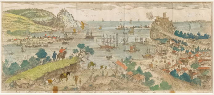
Sold2023Set of Hand-colored Views of Italy & FranceItalian, 18th century or earlier engravings with hand-colored details, 1) depicting Genova, 9 1/4" x 14 1/2" sight, 13" x 21 1/4" framed; 2) depicting the city of Nice, 6 1/4" x 14 1/2" sight, 13 1/4"See Sold Price
Sold2020Levasseur, Victor 1869 Lot 6 HC Decorative Maps FranceHand Colored Steel Engraved Decorative Map Published C1850, Paris for "Atlas National Illustre" by Victor Levasseur. Paper Size: 20.5 x 14.5 inch (52 x 37cm) Good ConditionSee Sold Price
3 days LeftTrillium Antique Prints & Rare BooksCatesby, Folio - Green Turtle with Turtle Grass. 2-38$200
3 days LeftTrillium Antique Prints & Rare BooksCatesby, Folio - Cecropia Moth with Custard Apple. 2-86$200
3 days LeftTrillium Antique Prints & Rare BooksCatesby, Folio - Nuthatch & Small Nuthatch with Highland Willow Oak. 1-22$200
6 days LeftJasper52Large Antique French map GERMAN EMPIRE 1792 colored by POIRSON engraver Basset$170
3 days LeftTrillium Antique Prints & Rare BooksBraun & Hogenberg, pub. 1575 - View of Strasbourg, France$100(1 bid)
3 days LeftTrillium Antique Prints & Rare BooksBraun & Hogenberg, pub. 1575 - View of Orleans, France$100
3 days LeftTrillium Antique Prints & Rare BooksBraun & Hogenberg, pub. 1575 - View of Rimini, Italy$200(2 bids)
3 days LeftTrillium Antique Prints & Rare BooksBraun & Hogenberg, pub. 1575 - View of Szczecin (Stettin), Poland$100
3 days LeftTrillium Antique Prints & Rare BooksBraun & Hogenberg, pub. 1575 - View of Lucca, Italy$100(1 bid)
3 days LeftTrillium Antique Prints & Rare BooksBraun & Hogenberg, pub. 1575 - View of Crete und Corfu$100


![[COLOR PLATE BOOK]. KELLY, Christopher. History of the Fren... (1 of 3)](https://p1.liveauctioneers.com/928/328184/176813585_1_x.jpg?height=282&quality=70&version=1714496988)


