Sold2017A FRAMED 1879 MAP OF BOSTON HARBOR BY THAXTER AND SONSA FRAMED 1879 MAP OF BOSTON HARBOR BY THAXTER AND SONS PUBLISHERS. 23" x 15 1/2" SITE TEARS AT BORDERSSee Sold Price
Sold2024Antique 1883 Eldridge's Chart Long Island SoundAntique 1883 Eldridge's Chart Long Island Sound From Newport to New York by Geo. Eldridge, Hydrographer and Published by S. Thaxter & Son. The map is framed in a metal map frame with no glass. The mapSee Sold Price
Sold2021FRAMED MAP OF CAPE CODFramed map of Cape Cod. Very colorful. Drawn by Clara Chase. 35H X 28WSee Sold Price
Sold2018Samuel Thaxter Maritime CompassNineteenth century ship's compass by Boston maker S. THAXTER & SON with brass bowl, fitted to a timber box with sliding cover. Box is a 7 inch square x 5 inches high.See Sold Price
Sold2022FRAMED VINTAGE 20'S TRAVEL MAP BIRD'S EYE VIEW OF BOSTON HARBOR 15 3/4" X 20" W/ COVER 7" X 7 1/2"FRAMED VINTAGE 20'S TRAVEL MAP BIRD'S EYE VIEW OF BOSTON HARBOR 15 3/4" X 20" W/ COVER 7" X 7 1/2"See Sold Price
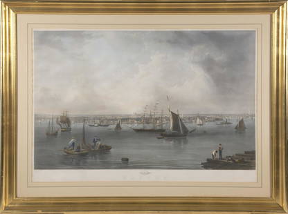
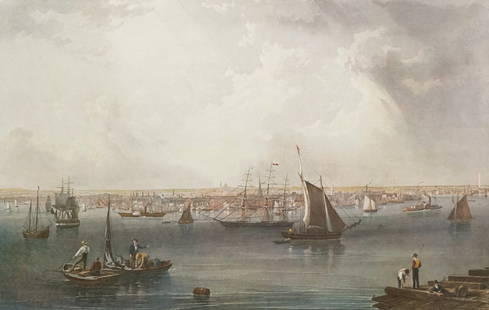
Sold2022AFTER JOHN WILLIAM HILL (America, 1812-1879), BostonAFTER JOHN WILLIAM HILL America 1812-1879 Boston Harbor. Engraving by C. Mottram. Published by Smith Brothers Co., New York. Hand-colored engraving on paper, 26.25" x 39". Framed 37" x 49".See Sold Price
Sold2023Charles Mottram, "Boston"Charles Mottram (British, 1807-1876), hand-colored engraving after John William Hill (American, 1812-1879) depicting the Boston Harbor, 20" x 31 1/2" image size, 32 1/2" x 43" framed.See Sold Price
Sold2016Original 1892 Map of Provincetown1892 map of Provincetown by Walker. Map shows Wellfleet, Truro, and Provincetwon with all roads of the day. Nicely framed. Overall Dimensions: 31" x 24"See Sold Price
Sold2019Cohasset harbor map and chartWAR DEPARTMENT MAP AND CHART OF COHASSET HARBOR. Detailed map of the South Shore from Boston to Cohasset showing harbors and coves including Whitehead, Bailey Creek, Bassing Beach etc.. Framed . DimenSee Sold Price
Sold20161771 Map of East River1771 map of a small portion of Manhattan's East River at Tuttle bay, now known as Turtle Bay. It extends from 43rd to 53rd streets. Tuttle Bay is described as a farm. Framed and matted. Dimensions: 22See Sold Price
Sold2017UNITED STATES 1860 MAP, J.W. LOWRY, TERRITORIESFramed map of "The United States of North America (General Map)", c. 1860, "drawn and engraved by" J.W. Lowry (Joseph Wilson Lowry, British, 1803-1879), published by Blackie & Son, Glasgow, EdinburghSee Sold Price
Sold2017Boston Harbor and the North ShoreTitle/Content of Map: Boston Harbor and the North Shore Date Printed: 1907 Cartographer: Walker Lithograph and Publishing Company Size (in): 20 x 13 Orginal antique birdseye view folding map of BostonSee Sold Price
Sold2017Map of Boston Harbor, 1882Map: Boston Harbor Cartographer: Walker-Potter, British Admiralty Place & Date: London / 1882 Size: 38 3/4" x 26 1/2" Condition: b&w, minor marginal nicks A spectacularly detailed British Admiralty chSee Sold Price
Sold2021August Mitchel Jr. 1860 Framed Map Of BostonThis August Mitchel Jr. hand-colored lithograph is circa 1860. The work is a plan of Boston's different areas, and a blow up on the right bottom corner details the area around Boston, as well as the hSee Sold Price
Sold2023Captain John Bonner Framed Map of BostonPrinting by George C. Smith of Capt. John Bonner's "The Town of Boston in New England". Frame measures approximately 27.5" x 21.75". Original price was $300.00 (see last photo). Estimated shipping cosSee Sold Price
Sold2019John Stobart Signed Lithograph Boston HarborJohn Stobart Signed and Framed Lithograph Boston Harbor. Of the Clipper Ship Lightening. Pencil signed and numbered 609/750. 32 inches x 40 inchesSee Sold Price
Sold20221878 HUGE MAP of Massachusetts & Boston Harbor Rand McNally Plymouth1878 HUGE MAP of Massachusetts & Boston Harbor Rand McNally Plymouth Rand McNally was a notable 19th and early 20th-century American publishing company known for their maps and travel atlases. This enSee Sold Price
Sold2019S. THAXTER & SON, BOSTON VINTAGE COMPASSHeight- 7 1/4" Diameter- 4 1/4" In-house shipping available within continental U.S. for $40 plus insurance.See Sold Price
Sold2023Constitution/Boston Harbor PrintsConstitution/Boston Harbor framed prints, lot of (2), 23" x 29". Provenance: North Hampton, New Hampshire collection.See Sold Price
Sold2023Mariner's Ship's Binnacle, Samuel Thaxter & SonMariner's Wet Card Ship's Binnacle, Samuel Thaxter & Son, Boston, Massachusetts, 1825-43. The gimballed wet card compass with bezel inscribed "Sold by S. THAXTER & SON Boston," housed in a walnut caseSee Sold Price
Sold2023Large 1876 chart of Long Island Sound from Newport to New York. Compiled by George Eldridge, publishLarge 1876 chart of Long Island Sound from Newport to New York. Compiled by George Eldridge, published by S. Thaxter & Son, Boston. Nautical chart with notable coastal towns and landmarks. Canvas backSee Sold Price
Sold2015AMERICAN SHIP CAPTAIN'S TELESCOPE, SINGLE DRAWMADE BY SAMUEL THAXTER & SON, BOSTON WITH ORIGINAL LEATHER COVER, 44" LONG (OPEN), 29" (SHUT), MISSING LENS COVER.See Sold Price
Sold2023BRASS CASED COMPASSMarked ,"S thaxter&son, boston. 3 x 1.5 inches.CONDITION:Good antique condition. Expected wear.See Sold Price
May 29Cedarburg Auction & Appraisals LLCRare 1877 Double sided map of Milwaukee and Wisconsin$25(1 bid)
May 22Thomaston Place Auction GalleriesCOLLECTION OF TRAVEL EPHEMERA, BROCHURES, BOOKLETS, MAPS 1900-1950$100
2 days LeftPotter & Potter AuctionsKEMP-WELCH, Lucy (1869 – 1958). FORWARD! 1915. Middlesex: D...$300
21 hrs LeftWorld Auction Gallery LLCFramed Reproduction of an Antique Map of Iceland by Georgio Carolo$30
BonhamsJACOB EDUARD VAN HEEMSKERCK VAN BEEST (Dutch, 1828-1894) Quiet Harbor with Sailing Ships framed...$300(5 bids)
2 days LeftPotter & Potter AuctionsAVEDON, Richard (1923 – 2004). The Beatles. Set of 4 poster...$500