Sold2016*ANTIQUARIAN 17TH C. HANDCOLORED ENGRAVED MAPAmerica's northeast state coast line with Massachusetts, New York and possibly Virginia, as well as unexplored provinces of Canada including Quebec, approximate plate size 15" x 20", frame 21 1/2" x 2See Sold Price
Sold2022Early 1847 school atlas map of East Coast statesEarly map of Maryland, Virginia, North Carolina and Delaware from Smith’s Quarto Geography published 1848 by Cady & Burgess. Very few railroad lines shown, as the industry was still in its infanSee Sold Price
Sold2021A Fine Antique Burlwood Inlaid Pipe North East CoastA Fine Antique Burlwood Inlaid Pipe North East Coast. Measure 7 1/4" x 4 3/4". From A Scott City Mo Estate.See Sold Price
Sold2018Weller: Antique Map of England North East Coast, 1863TITLE/CONTENT OF MAP: 'England and Wales' ENGLAND NORTH EAST COAST Lincs Yorks Durham Northumbs. >Berwick DATE PRINTED: 1863 IMAGE SIZE: Approx 45.5 x 32.5cm, 18 x 12.75 inches (Large) TYPE: Antique mSee Sold Price
Sold2020Vintage Straw Box Northeast Coast Indian 1940Handmade Native American original vintage straw matchbox. Likely East Coast tribe circa 1940. FREE DOMESTIC SHIPPING.See Sold Price
Sold2020Engraved Map of the East Coast of AmericaJacques-Nicolas Bellin (1703-1772), "Carte Reduite des Costes Orientales de L'Amerique Septentrionale," Paris, 1757. Hand colored engraved map of the northeast coast of North America, showing what isSee Sold Price
Sold20232 Trees Dawn Fades-Simon Jones, Grimsby, EnglandArtist: Simon Jones Simon Jones was born in Grimsby, England. Once the second largest fishing port of its kind in the world, Grimsby sits directly on the North East coast fringed by what is known as 'See Sold Price
Sold2017Blunt: Antique Blueback Chart of NECoast of USA, 1852Map: North East Coast of North America (Blueback). North East Coast of North America: From the U.S. Coast, Admiralty and Edmund Blunt's Surveys Date Printed: 1852 Cartographer: Blunt, Edmund Size: 56See Sold Price
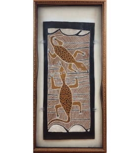
Sold2023RARE Bark Painting, Groote Eylandt, North Coast Australia 2 Of 2RARE Bark Painting, Groote Eylandt, North Coast Australia 2 Of 2. Shadowbox Frame Measure 47" X 20 3/4" X 2". This bark painting comes from one of the north-east coast barrier islands, Groote Eylandt.See Sold Price
Sold2020Bowen, Thomas 1789 Map of North America. USA Canada"A New & Accurate Map of North America including Nootka Sound, with the new discovered Islands on the North East Coast of Asia" Copper Engraved Map Published 1789-91 by C. Cooke, London for "The New RSee Sold Price
Sold2023Group of 4 Vintage Indian BasketsA north-west coast Makah basket bottom, 3m 1/2 inch - a 6 inch Cherokee basket with tag - North-east coast rectangular lidded basket 7 x 4 x 3- and a covered round north-east coast basket, 8 x 4 incheSee Sold Price
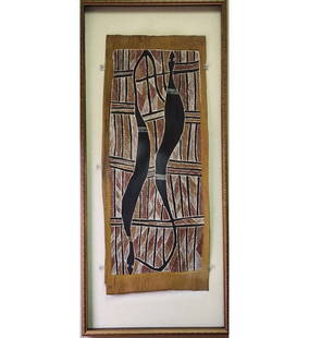
Sold2023RARE Bark Painting, Groote Eylandt, North Coast Australia 1 Of 2RARE Bark Painting, Groote Eylandt, North Coast Australia 1 Of 2. Shadowbox Frame Measure 31 1/2" X 15.5" X 2". This bark painting comes from one of the north-east coast barrier islands, Groote EylandSee Sold Price
Sold2023John Cary, Map of Part of United States, C1800John Cary, "A New Map of Part of the United States of North America" (northeast coast), hand-colored engraving, London 1799-1807, 18" x 20", matted and framed 22 1/2" x 25 1/2". Provenance: MarbleheadSee Sold Price
Sold2016Stunning Japanese Carving of Oni19th cen, meiji period, master carving of tokyo school, depicting oni marching on a praying road. Provenace: from a Northeast Coast Collection, measures 10"h 519th cen, of lovely meiping form, plum blSee Sold Price
Sold2016Pair Chinese Bronze Seated Lohan on Square Base 18th18th cen bronze Lohan of Sino Tibet influence, rich reddish brown patina, heavy in cast, measures 7.5" in height, 5" in width; Provenace: from a Northeast Coast CollectionSee Sold Price
Sold2016Large Tibetan Bronze Ewer with FigurineProvenance: from a Single Northeast Coast Collection, measures 11"h 12"wSee Sold Price
Sold2016Unusual Chinese Pebble Jade Toggle of Fish and Shell18/19th cen, with partial skin, unusual sea shell and fish subject mater, measures 1.75"; Provenance: from a Northeast Coast CollectionSee Sold Price
Sold2023CHART: UNITED STATES - EAST COAST/ NORTH CAROLINA/ Pamlico Sound - Western Part.Description: CHART: UNITED STATES - EAST COAST/ NORTH CAROLINA/ Pamlico Sound - Western Part.Measurement approximate: 35 x 44 InchesSee Sold Price
Sold2019Two Maps from the Hydrographic Office U. S. Navy, theTwo Maps from the Hydrographic Office U. S. Navy, the first "Asia, Korea, Southeast Coast, Fusan Ko," 1945, H. - 42 in., W. - 30 in.; together with "England- East Coast, North Foreland to Orfordness,See Sold Price
Sold20181639 Janssen Map of East Coast of North America -- NovaTitle/Content of Map: 1639 Janssen Map of East Coast of North America -- Nova Anglia Novum Belgium et Virginia Date: 1639 c. Amsterdam Cartographer: J Janssen Size: 15.3 x 19.7 in. This is an importanSee Sold Price
Sold2023Map: United States– East Coast Connecticut/ North shore of Long Island SoundDescription: United States– East Coast/ Connecticut/ North shore of Long Island Sound. Sherwood Point to Stamford Harbor. Published at Washington D.C. US Department of Commerce, National OceaniSee Sold Price
Sold2021James Rizzi [PAWLEY CREATIVE ARTS CENTER GALLERYJames Rizzi (1950-2011) [PAWLEY CREATIVE ARTS CENTER GALLERY EXHIBITION]; [CITYSCAPE]; EAST COAST COLLISION; THE LOWER EAST SIDE; YOUNG AUDIENCES Five prints, signed in pencil, with full margins, unfrSee Sold Price
Sold2024TWO NAUTICAL CHARTSEast Coast of North America 1870, 47 inches by 33 inches. George W. Eldridge Chart of Kennebec River to Deer Isle, 1916, 35 inches by 59 inches. Together with blue print of the US Merrimack and an 183See Sold Price
Sold2020Le Rouge Map of Theatre de la Guerre en AmeriqueGeorge Louis Le Rouge (fl.1740–80), "Theatre de la Guerre en Amerique," Paris: Le Rouge, 1777. A nice Revolutionary War period map of the east coast of North America from northern Florida to NeSee Sold Price
Jun 29JM Hobby Supply and Railroad Artifact AuctionsFlorida East Coast RY Rococo Pattern Dinner Plate$20
Jun 06Lyon & Turnbull§ JAMES MCINTOSH PATRICK R.S.A, R.O.I., A.R.E., L.L.D. (SCOTTISH 1907-1998)£1,600
2 days LeftJasper52Dalmatia, Istria, Bosnia, Servia, Croatia… ROSSI / CANTELLI DA VIGNOLA 1684 map$260
3 days LeftLeland LittleMichael Gandy and Benjamin Baud (English, Mid 19th Century), Four Plates from Gandy and Baud's$50
Featured2 days LeftJasper52Chart of the Sea Coasts of England, Flanders & Holland. MOUNT & PAGE 1758 map$420
5 days LeftTrillium Antique Prints & Rare BooksPrevost - Pair of Engravings of Indian Coast and Ocean$50


![James Rizzi [PAWLEY CREATIVE ARTS CENTER GALLERY: James Rizzi (1950-2011) [PAWLEY CREATIVE ARTS CENTER GALLERY EXHIBITION]; [CITYSCAPE]; EAST COAST COLLISION; THE LOWER EAST SIDE; YOUNG AUDIENCES Five prints, signed in pencil, with full margins, unfr](https://p1.liveauctioneers.com/292/209751/106790734_1_x.jpg?height=310&quality=70&version=1625153132)


