Sold2024Ruth Taylor - Map of West Virginia, United States1930's Vintage WEST VIRGINIA State Map. Ruth Taylor maps present an exciting entertaining view of the individual states at a time when things were a little more freestyle in the realm of political corSee Sold Price
Sold2016Map of the States of Virginia, North Carolina...Jedidiah Morse (1761-1826), Engraved by Amos Doolittle. New Haven: Doolittle, 1788. Engraved Map. 13 1/2 x 15 1/4 inches paper size.See Sold Price
Sold20231862 Civil War, Coltons New Topographical Map of The States of Virginia, Maryland and DelawareHistoric Maps 1862 Civil War "Colton's New Topographical Map of The States of Virginia, Maryland and Delaware" Hardcover Folio 1862-Dated Civil War Period, Hand-colored 45.25" x 31.5" Folding Map titlSee Sold Price
Sold2022PURCELL, JOSEPH A Map of the States of Virginia North Carolina South Carolina and GeorgiaPURCELL, JOSEPH A Map of the States of Virginia North Carolina South Carolina and Georgia Comprehending the Spanish Provinces of East and West Florida... New Haven: Amos Doolittle, 1788. Engraved mapSee Sold Price
Sold2017A New Map of the States of Virginia North Carolina...and Georgia Comprehending the Spanish Provinces of East and West Florida Exhibiting the boundaries between the United States and Spanish Dominions as fixed by the Treaty of Peace in 1783 / CompiledSee Sold Price
Sold2023RARE BUCHOLTZ-LUDWIG ANTEBELLUM POCKET MAP OF VIRGINIARARE BUCHOLTZ-LUDWIG ANTEBELLUM POCKET MAP OF VIRGINIA, hand-colored lithograph, Map of the State of Virginia Containing the Counties, Principal Towns, Railroads, Rivers, Canals & All Other Internal ISee Sold Price
Sold201918th c. Purcell Map, "State of Franklin"Joseph Purcell: A MAP OF THE STATES OF VIRGINIA, NORTH CAROLINA, SOUTH CAROLINA, AND GEORGIA; Comprehending the SPANISH PROVINCES of EAST AND WEST FLORIDA. Scarce Edinburgh, Scotland imprint, circa 17See Sold Price
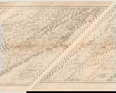
Sold2017Copy of Map of Virginia by Herman BoyeThe original dating to 1827 / 28 was engraved by H. S. Tanner and E. B. Dawson. Considered to be one of the first official state maps of Virginia. Multiple condition issues, including (but not limitedSee Sold Price
Sold2022[MAPS & ATLASES]. COLTON, J.H. (1800-1893). Colton's New Topographical Map of The States Of[MAPS & ATLASES]. COLTON, J.H. (1800-1893). Colton's New Topographical Map of The States Of Virginia, Maryland and Delaware, Showing Also Eastern Tennessee & Parts Of Other Adjoining States. New York:See Sold Price
Sold2017JOSEPH PURCELL (AMERICAN) MAP OF THE SOUTHEASTERNJOSEPH PURCELL (AMERICAN) MAP OF THE SOUTHEASTERN UNITED STATES, titled "A Map of the States of Virginia North Carolina South Carolina and Georgia, Comprehending the Spanish Provinces of East and WestSee Sold Price
Sold2023Postal Map VIRGINIA & WEST VA 1900 post routeHaake, A von; United States. Post Office Department.; Post Route Map of the States of Virginia and West Virginia : Showing Post Offices with the Intermediate Distances on Mail Routes in Operation on tSee Sold Price
Sold20211831 Hinton Map of Virginia, Maryland, Delaware andTitle: 1831 Hinton Map of Virginia, Maryland, Delaware and Washington DC -- Map of the States of Virginia, and Maryland Cartographer: J Hinton Year / Place: 1831, London Map Dimension (in.): 9.7 X 15.See Sold Price
Sold2019Colton's Virginia Map [Southern States]Colton's Virginia Map; Delaware on the right, Maryland on the left. J. H. Colton Cartographer. Published by J. H. Colton, New York. Stamped 'Entered according to Act of Congress in the Year 1855 by J.See Sold Price
Sold2022Pre-Civil War school atlas map of East Coast states, 1849Very nice map of East Coast states showing Virginia fourteen years before West Virginia becomes a state. Nice example with full original hand coloring. No. 4 Virginia, North Carolina, South Carolina,See Sold Price
Sold2019ANTIQUE MAP OF VIRGINIA & SURROUND STATE PARCELSANTIQUE MAP OF VIRGINIA & SURROUND STATE PARCELS / UNFRAMEDSee Sold Price
Sold2021County Map of the States of Delaware, Maryland,Publication Date: c1887 Title: County Map of the States of Delaware, Maryland, Virginia And West Virginia Cartographer: BRADLEY Publisher: BRADLEY & COMPANY Good atlas map with two small insets. On reSee Sold Price
Sold2018County Map of the States of Delaware, Maryland,Reserve Reduced! Title: County Map of the States of Delaware, Maryland, Virginia And West Virginia Publication Date: 1886 Cartographer: MITCHELL, S. AUGUSTUS, JR. Publisher: BRADLEY & BRO. Size: 14.5See Sold Price
Sold2016Antique Middle States Map - 1872Antique Middle States Map - 1872, featuring Maryland, Virginia, West Virginia, Pennsylvania, New York & New Jersey. Size : 9" x 10.75"See Sold Price
Sold20191848 Mitchell map of VirginiaFully hand-colored original, antique and scarce map that encompasses the future state of West Virginia. “A New Map of Virginia with its Canals, Roads & Distances from Place to Place Along the StageSee Sold Price
Sold2016Large 1862 US Civil War Wall MapColton's Map of the Southern States. Including Maryland, Delaware, Virginia, Kentucky, Tennessee, Missouri, North Carolina, South Carolina, Georgia, Alabama, Mississippi, Arkansas, Louisiana, Texas ..See Sold Price
Sold20165 maps (1838): VA, MD, DE, Balt., 4 cities.[United States/Virginia/MD/DE/DC] 5 Maps. Maps 6 and Maps 23-26 from T. G. Bradford, “An Illustrated Atlas, Geographical, Statistical, And Historical, Of The United States, And Adjacent Countries,��See Sold Price
Sold2024Second State of Morden's Map of Virginia c.1687Second State of Morden's Map of Virginia. Fine example of Robert Morden's map of Virginia, one of the earliest obtainable English maps of the Chesapeake the region. Beginning in the 1670s, theSee Sold Price
Sold2024Antique Civil War Era Hand-Colored Map of The Southern States, c. 1855Antique Civil War Era Hand-Colored Map of The Southern States, c. 1855. Maker: School Geography. Antique hand colored map of a southern section of the United States- Virginia (includes West Virginia),See Sold Price
Sold20241795 Map of the Southern States of AmericaRUSSELL, John C. (ca 1750-1829) Map of the Southern States of America, Comprehending Maryland, Virginia, Kentucky, Territory Sth. of the Ohio, North Carolina, Tennessee Government. South Carolina, & GSee Sold Price
4 days LeftBrunk AuctionsJohn Mitchell - A Map of the British and French Dominions in North America, 1755-1757$24,000
4 days LeftTrillium Antique Prints & Rare BooksCarey, pub. 1796 - 3 Maps of States in North America$75(1 bid)
Nov 03Modern JewelryNEW 14K YELLOW GOLD TEXAS STATE MAP PENDANT 14K YELLOW GOLD NEW TEXAS STATE MAP PENDANT WEIGHT: 2g$260
Nov 03Modern JewelryNEW 14K YELLOW GOLD FLORIDA STATE MAP PENDANT 14K YELLOW GOLD NEW FLORIDA STATE MAP PENDANT WEIGHT:$280
Nov 03Modern JewelryNEW 14K YELLOW GOLD CALIFORNIA STATE MAP PENDANT 14K YELLOW GOLD NEW CALIFORNIA STATE MAP PENDANT$335
1 day LeftJasper52Darbieshire. Derbyshire county map by John Speed. Bassett/Chiswell edition 1676$460
Featured11 hrs LeftJasper52No. 13 Map of the State of Texas Engraved to Illustrate Mitchell's School and Family Geography$55
4 days LeftTrillium Antique Prints & Rare BooksCarey, pub. 1796 - Map of the State of New Jersey$75(1 bid)


![[MAPS & ATLASES]. COLTON, J.H. (1800-1893). Colton's New Topographical Map of The States Of: [MAPS & ATLASES]. COLTON, J.H. (1800-1893). Colton's New Topographical Map of The States Of Virginia, Maryland and Delaware, Showing Also Eastern Tennessee & Parts Of Other Adjoining States. New York:](https://p1.liveauctioneers.com/197/265299/138516337_1_x.jpg?height=310&quality=70&version=1666051328)


![Colton's Virginia Map [Southern States]: Colton's Virginia Map; Delaware on the right, Maryland on the left. J. H. Colton Cartographer. Published by J. H. Colton, New York. Stamped 'Entered according to Act of Congress in the Year 1855 by J.](https://p1.liveauctioneers.com/5755/154409/77936948_1_x.jpg?height=310&quality=70&version=1573094011)


![5 maps (1838): VA, MD, DE, Balt., 4 cities.: [United States/Virginia/MD/DE/DC] 5 Maps. Maps 6 and Maps 23-26 from T. G. Bradford, “An Illustrated Atlas, Geographical, Statistical, And Historical, Of The United States, And Adjacent Countries,��](https://p1.liveauctioneers.com/179/85723/44107992_1_x.jpg?height=310&quality=70&version=1456876561)


![1891 Rand McNally Oregon [verso] Nevada -- Oregon [verso] Nevada (1 of 2)](https://p1.liveauctioneers.com/5584/343693/186665657_1_x.jpg?height=282&quality=70&version=1726603887)


