Sold2022Adverting/ Petrolins 15 Road MapsAdverting/ Petrolins 15 Road Maps Please refer to the pictures as they also help to form part of the description and reach out to us with any questions.See Sold Price
Sold2023Group of Phillips, Shell, Husky Road MapsApproximately 15 road maps, all in fair to good conditionSee Sold Price
Sold2023Group of Standard Oil & Affiliates Road MapsApproximately 15 road maps, all in fair to good conditionSee Sold Price
Sold2018UK Road Maps C1750-1785 Lot of 16. Paterson, BowenGood Lot of 16 Copper Engraved Road Maps. 15 by Paterson, Published 1785 by Carrington Bowles, London for "Paterson's British Itinerary" First Edition by Captain Daniel Paterson. Together with one hanSee Sold Price
Sold2018Rare 1921 auto road atlas. 11.7 x 15Reserve Reduced! This rare and unusual early auto road atlas was published during the time the National Highway System was being developed. It includes individual “auto-trails” maps for each stateSee Sold Price
Sold202457 Railroad Maps and 15 Magazines - New York Subway, NJ Transit, Union Pacific, Rand McNally,57 Railroad Maps and 15 Magazines - New York Subway, NJ Transit, Union Pacific, Rand McNally, Conrail, Burlington Northern, etc Group of fifty seven railroad maps and railroad map books. The group incSee Sold Price
Sold20241986 1st Edition Winston S. Churchill, Vol VII Road To Victory 1941-451986 1st Edition Winston S. Churchill, Vol VII Road To Victory 1941-45 by Martin Gilbert HC w/DJ. This book is in Very Good condition as pictured. It contains 1417 pages with 24 plates, 15 maps (someSee Sold Price
Sold2016City Plan of Washington DC, 1885Map: City Plan of Washington DC Cartographer: Cpt. Greene Publishing: 1885 Size: 15.5 x 20 inches Colorful and unusual street map of Washington DC. It also shows the railroads and roads in the capitalSee Sold Price
Sold2016J.H. Colton & Co.: Kansas & Nebraska 1857Map: Kansas and Nebraska Publishing: J.H. Colton & Co., Colton, Joesph Hutchins Date: 1857 Size: 24.3 x 15.75 inches Early development of Kansas and Nebraska in 1857. Shows railroads and common roads.See Sold Price
Sold2023VermontPublication Date: 1856 Title: Vermont Cartographer: COLTON, J.H. Publisher: J.H. COLTON & CO. Height: 15.5 Width: 12.75 Detailed map showing counties separately colored, towns, townships, roads, railrSee Sold Price
Sold2021Road Maps by Johnathan Schultz"Road Maps" by Johnathan Schultz is an original 3D sculpture created with 23kt gold leaf on Acrylic, 18kt gold plate. Frame Dimensions 13.5 x 13.5 x 4 inSee Sold Price
Sold2021Shell Tin Litho Road Maps DisplayCanadian. 1940s. Lithographed tin. Includes an assortment of seventeen (17) used road maps. Marked, "St. Thomas Metal Signs Ltd. St. Thomas Ontario" upper rear. 19 1/2 x 13". One added mounting hole tSee Sold Price
Sold2020Approximately 50 Antique Service Station Road MapsCirca 1920s-30s, Includes Nebraska, Michigan, Missouri, Iowa, Standard Oil, Sinclair, Shell, and MoreSee Sold Price
Sold2021Mobilgas road maps brochure displayMetal display with approximately 8- various maps. Includes several from Ohio, New York, Nebraska, Buffalo -Niagara, Minnesota and New England. 12 3/4 in wide 24 in tall.See Sold Price
Sold2022HUSKY GASOLINE SERVICE STATION MAP DISPLAY W/ HUSKY ROAD MAPS.SST. An excellent and complete example of this Circa 1950's Service Station Road Map Display from Husky showing a Tin Husky Sign at the face and complete with Maps. CONDITION: Display is in overall exSee Sold Price
Sold2020MOBIL GASOLINE SERVICE STATION TIN ROAD MAPS DISPLAY W/SST. A very nice example of this Service Station Road Maps Display from Mobil Gasoline. The paint and body are both in excellent condition, showing minimal age wear and minor surface scratches. The grSee Sold Price
Sold2022British road maps.- Ogilby (John) The Roads fromNO RESERVE British road maps.- Ogilby (John) The Roads from Chelmsford in Essex to St. Edmonds-Bury in Suffolk & Saffron-Walden in Essex, strip road map, engraving with hand-colouring, on thin laid paSee Sold Price
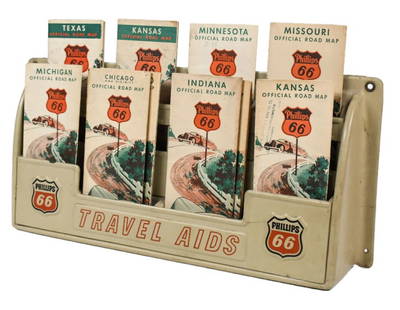
Sold2023Vintage Phillips 66 Road Map Embossed Display RackVintage Phillips 66 embossed plastic road map display rack full with original 1930s Phillips 66 maps. Rack has discoloration, some expected chips/ cracks, and wear from use and age. Displays well withSee Sold Price
Sold2020Grp: 15 Maps of FranceGroup of fifteen maps of France and other parts of Northern Europe. Includes Robert Sayer (1725–1794) "The Catholic Netherlands," London, 1788; Jan Jansson (1588-1664), engraved Everard SymonszSee Sold Price
Sold2023John Ogilby, Three Engraved Road Maps on laid paperJOHN OGILBY (Scottish, 1600-1676), Three Double Paged Hand Colored Engraved Road Maps on laid paper, including "The Road from London to St. Davids in Com. Pembroke," "The Road from London to St. NeottSee Sold Price
Sold2020Group of 30 Antique Service Station Road MapsCirca 1920s-30s, Includes Standard Oil, Sinclair, Esso, Phillips 66, Missouri, South Dakota, Ohio, Pennsylvania, and Many MoreSee Sold Price
5 days LeftRich Penn AuctionsPetroliana Oil Company Road Maps (45), assorted states & companies, most Phillips 66 & Chevron$50
5 days LeftRich Penn AuctionsPetroliana Oil Company Road Maps (50), assorted states & companies, most Phillips 66 & Gulf$50
5 days LeftRich Penn AuctionsPetroliana Oil Company Road Maps (50), assorted states & companies, most Mobil & Gulf 1940s-50s-60s,$50
3 days LeftAlbion AuctionsPaterson & Mogg C1830 British Road Map. Cumberland, Westmorland & Lancashire$5(1 bid)
3 days LeftAlbion AuctionsPaterson & Mogg C1830 British Road Map. New Shorehamd to Chichester to Fareham$5(1 bid)
3 days LeftAlbion AuctionsPaterson & Mogg C1830 British Road Map. Banks of the River Wye. Chepstow etc$5(1 bid)
3 days LeftAlbion AuctionsPaterson & Mogg C1830 British Road Map. Isle of Thanet and Adjacent Country$5(1 bid)
3 days LeftAlbion AuctionsPaterson & Mogg C1830 British Road Map. Rye to Eastbourne to New Shoreham$5
Jun 30JM Hobby Supply and Railroad Artifact Auctions15 Assorted Road and Track Die Cast Cars and Truck$10