Sold2019"Provincia di Kent". Kent county map. ZATTA 1779 oldTITLE/CONTENT OF MAP: 'Provincia di Kent di nuova projezione' The county of Kent The top image on the right hand side shows the entire map. To view a close up of the map showing the level of printed dSee Sold Price
Sold2022Kent.- Blaeu (Johannes) Cantium Vernacule Kent, engraved map with hand-colouring, [c. 1660].NO RESERVE Kent.- Blaeu (Johannes) Cantium Vernacule Kent, county map, engraving with early hand-colouring, platemark 400 x 530 mm (15 3/4 x 20 3/4 in), sheet 520 x 630 mm (20 1/2 x 24 3/4 in), centraSee Sold Price
Sold2018A Map Of The County Of Kent. Samuel Parker, 1719.[British Counties] A Map Of The County Of Kent. Samuel Parker, 1719. Folding map on 2 adjoined folding sheets, giving an impressively detailed depiction of rivers and towns in the county at the southeSee Sold Price
Sold2022FRAMED KENT COUNTY MD TOWN MAPS FROM ATLASALL MAPS FROM THE 1877 KENT COUNTY MD ATLASSee Sold Price
Sold20191818 Neele Map of Kent -- KentTitle/Content of Map: 1818 Neele Map of Kent -- Kent Date: 1818, London Cartographer: S Neele Size: 9.8 X 7.8 in. This is a nice and rather scarce map of Kent, a county in south-east England, includinSee Sold Price
Sold2022KENT – LYDD – MANUSCRIPT ESTATE MAP 'A Map of a Farm lying in the Parish of Lydd in ...KENT – MANUSCRIPT ESTATE PLAN 'A Map of a Farm lying in the Parish of Lydd in the County of Kent Belonging to the Reverd. Mr Richard Monins 1774.', manuscript map by Henry Maxted & Isaac Terry,See Sold Price
Sold2021Framed Handkerchief Map of CTwith scenes from Kent Falls, Harkness Tower-Yale, & the State Capital-Hartford. Framed, not examined out of frame. Frame size: 18" high, 18" wide. Provenance: Property of a Fairfield County CT CollectSee Sold Price
Sold2022FARMING:FARMING: FARMING: VANCOUVER, C: General View of the Agriculture of the County of Cambridge. 1794, 1st. edn. In two parts. 4to. Covers detached & lacking part of the spine; lacking Map; KENT, N: GeneraSee Sold Price
Sold2016Antique Map, County of Southampton, Greenwood & Co.Greenwood & Co. (British, 19th century), "Map of the county of Southampton from an Actual Survey, made in the years 1825 & 1826," hand-colored copper-engraved map, engraved by J. and J. Neele, publishSee Sold Price
Sold2023An 1860 Map, Counties of New York, New Hampshire, Etc...Hand colored lithograph, by Samuel Augustus Mitchell (1790-1868). :County Map of the States of New York, New Hampshire, Vermont, Massachusetts, Rhode Island and Connecticut". Dimensions:15 1/2" x 23 1See Sold Price
Sold2023Antique Map County of Cumberland EnglandAntique Framed and Hand Colored Map of the County of Cumberland, England by Richard Blome (London Engraver 1600-1705) . 16 inches x 13 inchesSee Sold Price
Sold2023Antique Map County of Northumberland EnglandAntique Framed and Hand Colored Map of the County of Northumberland, England by Richard Blome (London Engraver 1600-1705) . 16 inches x 13 inchesSee Sold Price
Sold2016Antique Map, County of Dorset from an Actual Survey,Greenwood & Co. (British, 19th century), "Map of the county of Dorset from an Actual Survey, made in the years 1825 & 1826," 1829, hand-colored copper-engraved map, engraved by H. Frost, published inSee Sold Price
Sold2022Moule, Thomas C1845 British Map. KentSteel Engraved Map Published C1845, London for "A Complete and Universal English Dictionary" by the Rev. James Barclay et al. Maps by Thomas Moule. Paper Size: 10.5 x 8 inch (27 x 21cm) Good ConditionSee Sold Price
Sold2021Wilkes, John 1811 Map. KentCopper Engraved Map Published 1796-1828 London for "Encyclopaedia Londinensis, or universal dictionary of arts, sciences and literature" by John Wilkes et al. Paper Size: 10.5 x 8.5 inch (27 x 22cm) SSee Sold Price
Sold2020d'Anville, Jean Baptiste C1760 Map Kent English ChannelMap of Kent, showing Isle of Thanet, Dover, Canterbury, Hythe. Also showing Northern France - Calais, Boulogne etc. Copper Engraved Map Published 1736-1808, Paris for "Histoire de l'Acade?mie royale dSee Sold Price
Sold2020Moule, Thomas C1838 British Map. KentSteel Engraved Map Published C1838 for "A Complete and Universal English Dictionary" by the Rev. James Barclay et al. Maps by Thomas Moule. Paper Size: 10.5 x 8 inch (27 x 21cm) Tone mark, right side.See Sold Price
Sold2020Moule, Thomas C1850 British Map. KentSteel Engraved Map Published C1850 "A Complete and Universal English Dictionary" by the Rev. James Barclay et al. Maps by Thomas Moule. Paper Size: 10.5 x 8 inch (27 x 21cm) Good ConditionSee Sold Price
Sold2021Moule, Thomas C1835 British Map. KentSteel Engraved Map Published C1835, London for "A Complete and Universal English Dictionary" by the Rev. James Barclay et al. Maps by Thomas Moule. Paper Size: 11 x 8.5 inch (28 x 22cm) Very minor marSee Sold Price
Sold2017(3) antique and decorative Maps: Kent, Paris, NY(3) antique and decorative Maps: Kent, Paris, NY, 19th and 20th c., Kent: 8.5"h x 8.5"w (sight)See Sold Price
Sold2022SAMUEL AUGUSTUS MITCHELL JR., AN AMERICAN CIVIL WAR ERASAMUEL AUGUSTUS MITCHELL JR., AN AMERICAN CIVIL WAR ERA MAP, "County Map of Texas," CIRCA 1863, hand-colored lithograph on paper with profusely floral and fruit border, plate 34. from Mitchell's New GSee Sold Price
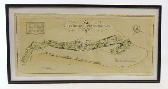
Sold2019Scotland Early Golf MapOld Course St. Andrews Map. Surveyed by A. MacKenize Architect, 1924. McCorquodale & Co., Glasgow, C. 1924. Sight 10 3/4" x 24 1/2".See Sold Price
Sold2018County Map of Texas.Title/Content of Map: County Map of Texas. Date Printed: 1870 Cartographer: MITCHELL, SAMUEL AUGUSTUS (JR.) Material/Medium: S. Augustus Mitchell, Jr. Size: 9.25X12 Inset of Galveston Bay and VicinitySee Sold Price
4 hrs LeftJasper52New Map of That Portion of North America Exhibiting the United States and Territories...Mexico...$360
May 16Potter & Potter AuctionsMcCARTY, Lea (1905 – 1960). Sonoma County / Its Highlights ...$100(1 bid)
14 hrs LeftAdam's AuctioneersPLOWDEN, Francis: An Historical Review of The State of Ireland [5 vols.] Philadelphia (William Mc€240(1 bid)


![Kent.- Blaeu (Johannes) Cantium Vernacule Kent, engraved map with hand-colouring, [c. 1660].: NO RESERVE Kent.- Blaeu (Johannes) Cantium Vernacule Kent, county map, engraving with early hand-colouring, platemark 400 x 530 mm (15 3/4 x 20 3/4 in), sheet 520 x 630 mm (20 1/2 x 24 3/4 in), centra](https://p1.liveauctioneers.com/5458/260724/135800539_1_x.jpg?height=310&quality=70&version=1662479034)
![A Map Of The County Of Kent. Samuel Parker, 1719.: [British Counties] A Map Of The County Of Kent. Samuel Parker, 1719. Folding map on 2 adjoined folding sheets, giving an impressively detailed depiction of rivers and towns in the county at the southe](https://p1.liveauctioneers.com/179/117971/60557711_1_x.jpg?height=310&quality=70&version=1520636872)


![PLOWDEN, Francis: An Historical Review of The State of Ireland [5 vols.] Philadelphia (William Mc (1 of 4)](https://p1.liveauctioneers.com/533/325941/175488528_1_x.jpg?height=282&quality=70&version=1712845571)


![[SLAVERY DOCUMENT]. Manuscript Slave Appraisal. Wilcox Coun... (1 of 2)](https://p1.liveauctioneers.com/928/328184/176813737_1_x.jpg?height=282&quality=70&version=1714496988)


