Sold2021Antique Map of Captain James Cook's Voyages to theAntique map of Captain James Cook's voyages to the Pacific region. Captain Cook made numerous discoveries in the Pacific region during the late 1700's . Artists and mapmakers aboard the ship, includinSee Sold Price
Sold2022Antique Map Print of Oceania - Map of Madeira & The Azores - 1870 - James CookOriginal Antique Decorative Map of Madeira & The Azores, Fullarton, C.1870 This fascinating folio engraving is from Captain James Cook & James King's "A Voyage to the Pacific Ocean, for making DiscoveSee Sold Price
Sold2023T Bowen Early Antique Map incl Discoveries by Captain Cook in North AmericaT Bowen Early Antique Map incl Discoveries by Captain Cook in North America MEDIUM: Printed and Published DIMENSIONS: 9.75 X 8.25 inches CIRCA: 1780 ATTRIBUTION: T. Bowen DESCRIPTION: This lot is a fiSee Sold Price
Sold20241842 VOYAGES OF CAPTAIN JAMES COOK 2 VOLUMES antique ILLUSTRATEDThe Voyages of Captain James Cook London: William Smith, 1842 2 volumes Size 7 by 9 3/4" Additional engraved title in volume I, engraved frontispieces, double-page maps, in-text vignettes, etc. MinorSee Sold Price
Sold2021Antique French map of Northern America engravingAntique French map of Northern America engraving Charles V. Monin (18..-1880). Charles V. Monin (18..-1880) was a French cartographer and publisher, three important atlases and several independent worSee Sold Price
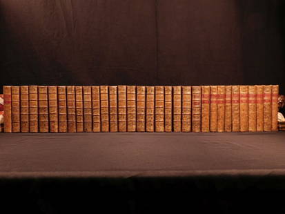
Sold20181780 1ed RARE Complete VOYAGES Maps Captain Cook Americ1780 1ed RARE Complete VOYAGES Maps Captain Cook America Explorers Africa 32v The best book of its kind! An extremely rare, 32-volume complete set of La Harpe’s ‘General History of Voyages’! ThiSee Sold Price
Sold20181780 1ed RARE Complete VOYAGES Maps Captain Cook1780 1ed RARE Complete VOYAGES Maps Captain Cook America Explorers Africa 32v The best book of its kind! An extremely rare, 32-volume complete set of La Harpe’s ‘General History of Voyages’! ThiSee Sold Price
Sold2018de l'Isle: Antique Map of Northern South America, 1730Map: Carte de la Terre Ferme, du Perou, du Bresil, et du Pays des Amazones Cartographer: de l'Isle / Buache Place & Date: Paris / 1730/1782 Size: 22 3/8" x 19 1/2" Condition: wash color; overall age-tSee Sold Price
Sold2017Cassini: Antique Map of Northern South America, 1798Map: La Terra Ferma e la Guiana Co' suoi departimenti Cartographer: Cassini Place & Date: Rome / 1798 Size: 14 1/4" x 19 1/4" Condition: outline color; light overall age toning; some fraying on outerSee Sold Price
Sold2023Barclay, James 1808 Antique Map. North America - USA Canada"North American from the best Authorities" by Scarce issue Engraved by Lawson, Halifax. Copper Engraved Map Published 1806, London for "Barclay's Complete and Universal English Dictionary" by the Rev.See Sold Price
Sold2023Barclay, James 1808 Antique Map. North America & The West Indies"North America and The West Indies with the latest discoveries" Scarce issue Engraved by Topham, Leeds. Copper Engraved Map Published 1806, London for "Barclay's Complete and Universal English DictionSee Sold Price
Sold2019Barclay, James 1809 Antique Map. North America"North America and The West Indies" Outline Hand Coloured Copper Engraved Map Published 1809, Leeds for "Barclay's Complete and Universal Dictionary of the English Language..." by the Rev. James BarclSee Sold Price
Sold2019Barclay, James 1809 Antique Map. South AmericaOutline Hand Coloured Copper Engraved Map Published 1809, Leeds for "Barclay's Complete and Universal Dictionary of the English Language..." by the Rev. James Barclay. Paper Size: 10 x 8 inch (26 x 20See Sold Price
Sold20181780 1ed VOYAGES Captain Cook Maps Comm Byron America1780 1ed VOYAGES Captain Cook Maps Comm Byron America Explorers Africa 3v La Harpe The best book of its kind! A rare set of La Harpe’s ‘General History of Voyages’! This extensive work was begunSee Sold Price
2017Tallis/Rapkin: Antique Map of Captain Cook's VoyageTitle/Content of Map: 'The World on Mercator's Projection shewing the voyages of Captain Cook around the World' The track's of Cook's first, second and third voyages are shown, along with dates. DateSee Sold Price
Sold2020Becker, F. C1838 Antique Map. AmericaSteel Engraved Map with outline hand color Published C1838, London for "A Complete and Universal English Dictionary" by the Rev. James Barclay et al. Maps by F. Becker and others. Paper Size: 10.5 x 8See Sold Price
Sold2023Becker, F. P. C1845 Antique Map. AmericaSteel Engraved Map Published C1845, London for "A Complete and Universal English Dictionary" by the Rev. James Barclay and B. B. Woodward. Maps by F. P. Becker. Outline hand color. Paper Size: 11 x 8See Sold Price
Sold2022Antique Map Print of Oceania - Map of Old Rus' - Avachy Bay - James CookMap of Old Rus'. Avachy Bay, marine. Nicol 1785 engraved marine map with inset of the harbor of St. Peter and Paul. The relief is shown by dashes with sounding depths. This fascinating folio engravingSee Sold Price
Sold2021Findlay, Alex C1835 Antique Map. North AmericaSteel Engraved Map Published C1835 by Thomas Kelly, London for "A New and Universal English Dictionary" by the Rev. James Barclay. Maps Drawn & Engraved by Alexander Findlay. Paper Size: 10.5 x 8 inchSee Sold Price
Sold2023Russell & Barclay C1825 Antique Map. North America. USA CanadaCopper Engraved Map Published C1825., by Fisher & Son, "A Complete Atlas of the World" by John Russell et al. The companion Atlas to "A Complete and Universal English Dictionary" by James Barclay. PapSee Sold Price
Sold2021Findlay, Alex C1835 Antique Map. South AmericaSteel Engraved Map Published C1835 by Thomas Kelly, London for "A New and Universal English Dictionary" by the Rev. James Barclay. Maps Drawn & Engraved by Alexander Findlay. Paper Size: 10.5 x 8 inchSee Sold Price
Sold2024James Cook - Antique map Australia titled 'Gezigt van het Eil. Suffren'. Antique map of SuffrenAntique map Australia titled 'Gezigt van het Eil. Suffren'. Antique map of Suffren Island. Originates from 'Reizen Rondom de Waereld door James Cook (..)'. Artists and Engravers: Translated by J.D. PaSee Sold Price
Sold2023La Mappe Monde- Map of 3 Voyages of Captain CookAntique Map Print- La Mappe Monde, Depicting the Three Voyages of Captain Cook. Original was Drawn by Herisson, Hand Watercolored, Number 64 and Dated 1816. Measures 33 1/2" x 47" framed. Good ConditiSee Sold Price
Sold2023Russell & Barclay 1814 Antique Map. States of America. USACopper Engraved Map Published C1825., by Fisher & Son, "A Complete Atlas of the World" by John Russell et al. The companion Atlas to "A Complete and Universal English Dictionary" by James Barclay. PapSee Sold Price
May 09Hunt and Peck Estate Services, Inc.1784 Captain James Cook "A Voyage to the Pacific Ocean" 2 of 3 volumes$200(1 bid)
6 days LeftTrillium Antique Prints & Rare BooksWebber & Cook, Rare - View in the Island of Cracatoa$500
6 days LeftTrillium Antique Prints & Rare BooksWebber & Cook, Rare - A View in Oheitepeha Bay, in the Island of Otaheite$500
6 days LeftTrillium Antique Prints & Rare BooksWebber & Cook, Rare - A View in the Islands of Pulo Condore$500
3 days LeftJasper52The tropical discoveries of HMS Resolution… New Caledonia Vanuatu. COOK 1776 map$170
3 days LeftJasper52Entrée de Norton & Détroit de Bhering. Bering Strait Norton Sound BONNE 1790 map$30
Featured3 days LeftJasper52Entrée de Norton & Détroit de Bhering. Bering Strait Norton Sound BONNE 1788 map$30
Featured3 days LeftJasper52NW Coast of America & NE Coast of Asia… ROBERTS / DELAROCHETTE. Pacific 1794 map$700