Sold2023Antique Map Print - Map of World - Scheme of Oceanic and Continental BasinsDescription: This vibrant hand-colored map of the world was published in Chicago by Rand McNally in the last quarter of the 19th century for inclusion in the company’s geography textbook, McNallSee Sold Price
Sold2023Antique Print - World - Map of the World in Hemispheres - Philipp Cluver - 1701Title: Antique Print - World - Map of the World in Hemispheres - Philipp Cluver - 1701 Date: 1701 Material: Paper Dimensions: 27 cm x 13 cm Description: A detailed small map from ”IntroductionisSee Sold Price
Sold2022Antique Map Print - Map of Bohemia - Map of Czech Republic - KingdomAntique outline hand colored map from edition of Meyer’s world atlas, edited by Ludwig Ravenstein, published by Bibliographic Institute in 1872. Technique: Engraving. Place: Leipzig, Germany. SSee Sold Price
Sold2022Antique Map Print - North America - Africa - South America - WorldSet of 4 Map Prints. Hand-colored map print of the edition of 1851 from the work Universal Historical and Geographical Atlas ("Atlas Universel Historique et Geographique"). This iconic map contains diSee Sold Price
Sold2022Antique Map Print - Map of Schleswig - Holstein - Map of Germany - LauenburgAntique outline hand colored map from edition of Meyer’s world atlas, edited by Ludwig Ravenstein, published by Bibliographic Institute in 1872. Technique: Engraving. Place: Leipzig, Germany. SSee Sold Price
Sold2022Antique Map Print - Map of Mecklenburg-Schwerin - Map of Germany - Roman EmpireAntique outline hand colored map from edition of Meyer’s world atlas, edited by Ludwig Ravenstein, published by Bibliographic Institute in 1872. Technique: Engraving. Place: Leipzig, Germany. SSee Sold Price
Sold2022Antique Map Print - Map of Rheinprovinz - Map of Germany - Prussian StateAntique outline hand colored map from edition of Meyer’s world atlas, edited by Ludwig Ravenstein, published by Bibliographic Institute in 1872. Technique: Engraving. Place: Leipzig, Germany. SSee Sold Price
Sold2022Antique Map Print - Map of Pomerania - Map of Germany - South of the Baltic SeaAntique outline hand colored map from edition of Meyer’s world atlas, edited by Ludwig Ravenstein, published by Bibliographic Institute in 1872. Technique: Engraving. Place: Leipzig, Germany. SSee Sold Price
Sold2022Antique Map Print - Map of Oldenburg - Map of Germany - Lower Saxony - HunteAntique outline hand colored map from edition of Meyer’s world atlas, edited by Ludwig Ravenstein, published by Bibliographic Institute in 1872. Technique: Engraving. Place: Leipzig, Germany. SSee Sold Price
Sold2022Antique Map Print - Map of Hesja-Nassau - Map of Austria - Prussian ProvinceAntique outline hand colored map from edition of Meyer’s world atlas, edited by Ludwig Ravenstein, published by Bibliographic Institute in 1872. Technique: Engraving. Place: Leipzig, Germany. SSee Sold Price
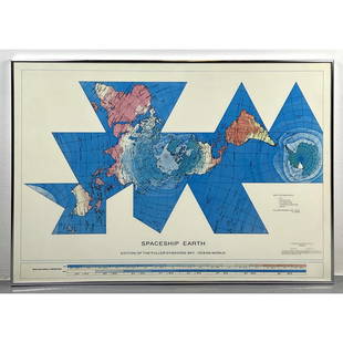
Sold2023Richard Buckminster Fuller Dymaxion World Map Print, 1980 FullerRichard Buckminster Fuller Dymaxion World Map Print, 1980 Fuller Dimensions: H: 22.5 inches: W: 34.5 inches --- -- We offer curbside delivery to NYC, Manhattan, Close Brooklyn, Hoboken about a week afSee Sold Price
Sold2020Framed Antique Map Orbis Vetus, Robert De VaugondyItem/Description: Old print. Map of the world by Robert de Vaugondy from 1752. Orbis vetus in utraque continente : In both the old continent / world map / Vaugondy 1752. Material: Print framed under gSee Sold Price
Sold2017TWO ANTIQUE BENTWOOD EASELS & MAP PRINTSEasels measure approx. 21 1/8" w x 55 3/4" h. Maps are vintage reproductions of the World & Europe compliments of Sanka Coffee.See Sold Price
Sold2017Pair of map prints in antique mahogany framesPair of world maps in antique mahogany frames with gilt border. 19"h x 16 1/2"wSee Sold Price
Sold2017Russell: Antique Map of World, 1804Map: 1804 Russell Map of World -- The World Cartographer: J. Russell Year / Place: 1804 London Map Dimensions: 4.5 x 6.5 in. Condition: Excellent condition, hand colored continental outlines; slight aSee Sold Price
Sold2018Antique Pair Of Maps Of America & The WorldAntique Pair Of Maps Of United States & World, these antique maps are both from W.C. Woodbridge, one map is a world map of the inhabited world, the other is a map of America, the prints have matting bSee Sold Price
Sold2021VINTAGE GOLD FOIL 1630 ANTIQUE WORLD MAPVINTAGE GOLD FOIL 1630 ANTIQUE WORLD MAP "Nova Totius Terrarum Orbis Geographica Ac Hydrographica TAbvla" Print, Framed. Size: 23 X 19 inches. Private Collection.See Sold Price
Sold2019ORBIS TERRARUM TYPUS DE INTEGROIN PLURIMIS WORLD MAPHuge 40" x 30" Framed Gold Foil Map 1660 Nicolaus Visscher Orbis Terrarum Print. Actual map is 21" x 31"See Sold Price
Sold2018McNally: Antique Chart Ocean Currents & Rain Fall, 1874Title/Content of Map: 1874 McNally Chart of the Ocean Currents and Rain Fall -- Ocean & Continental Basins, Ocean Currents and Co-Tidal Lines Date Printed: 1874 ca., New York Cartographer: F McNally SSee Sold Price
Sold2023Collection of Antique Prints "Cities of the World"Antique prints and etchings depicting "Cities of the World" - including Harper's Weekly illustrations, landscapes, antique maps, depictions of notable landmarks and famous cities such as Paris, New YoSee Sold Price
Sold2024Ptolemy & Magini, pub. 1620 - Double Hemisphere Map of the WorldThis early map engraving is from Claudius Ptolemaeus (Ptolemy) and Giovanni Antonio Magini's Geografia cio? Descrittione Universale della Terra Partita in due volumni, Nel Primo de' quali si contengonSee Sold Price
Sold2023Kircher, pub. 1678 - Map of the World including Americas (Hydrographic & Subterranean Markings)This scientific engraving is Athanasius Kircher's Mundus subterraneus, in XII Libros digestus; Qvo Divinum Subterrestris Mundi Opificium, mira Ergasteriorum Natur? in eo distributio, verbo PantamorphoSee Sold Price
Sold2024Carey, pub. 1814 - Map of the State of TennesseeThis engraved map is from Mathew Carey's General Atlas, improved and enlarged: being a collection of maps of the world and quarters, their principal empires, kingdoms, &c. The work was published in PhSee Sold Price
Sold2024Carey, pub. 1814 - Map of Mexico or New SpainThis engraved map is from Mathew Carey's General Atlas, improved and enlarged: being a collection of maps of the world and quarters, their principal empires, kingdoms, &c. The work was published in PhSee Sold Price
2 days LeftJasper52World War 2. Guadalcanal Campaign. Landing 7 Aug 1942 & Concurrent Ops 1959 map$10
2 days LeftJasper52World War 2. Guadalcanal Campaign 7-8 Aug 1942 Tulagi Landing Schedule 1959 map$10
2 days LeftJasper52World War 2. Guadalcanal Campaign 7-8 Aug 1942 Landing. Henderson Field 1959 map$10
Featured2 days LeftJasper52Bismarck Archipelago New Guinea New Britain 1943/4. Ports. World War 2 1961 map$8
2 days LeftJasper52MELANESIA.New Caledonia.Ponérihouen-Bourail.WW2 ROYAL NAVY INTELLIGENCE MAP 1944$10
4 days LeftTrillium Antique Prints & Rare BooksPtolemy & Magini, pub. 1620 - Map of the World$50(1 bid)
4 days LeftTrillium Antique Prints & Rare BooksPtolemy & Magini, pub. 1620 - Map of the Ancient World with Africa, Europe, Asia$50
4 days LeftTrillium Antique Prints & Rare BooksMitchell's A New Universal Atlas.. - Volume with 73 Maps$1,000(1 bid)
4 days LeftTrillium Antique Prints & Rare BooksCarey, pub. 1814 - Map of Hindostan or India$50(1 bid)