Sold2017Antique Navigation Chart of Grand Ocean, 1818Map: Carte Reduite du Grand Ocean comprise L'Asie et L'Amerique Date Printed: 1818 Cartographer: Depot de la Marine Size: 35 x 24 Condition: Good condition. Some browning and finger marks but overallSee Sold Price
Sold2018McNally: Antique Chart Ocean Currents & Rain Fall, 1874Title/Content of Map: 1874 McNally Chart of the Ocean Currents and Rain Fall -- Ocean & Continental Basins, Ocean Currents and Co-Tidal Lines Date Printed: 1874 ca., New York Cartographer: F McNally SSee Sold Price
Sold2023Anson, Lord 1748 Antique Map. A Chart of the Pacific Ocean"A Chart of the Pacific Ocean from the Equinoctial to the Latitude of 39d 1/2 No." Copper Plate Published London 1747-1815 for "The Universal Magazine of Knowledge and Pleasure" by Various. Folds as iSee Sold Price
Sold2017Ferrer: Antique Nautical Chart of Virgin Gorda, 18091809 Nautical Chart of Virgin Gorda BVI. Original engraving from José Joaquín de Ferrer y Cafranga's sea atlas, the 'Portulano de los Estados Unidos', published in Madrid in 1818. Ferrer devised theSee Sold Price
Sold2017Ferrer: Antique Nautical Chart of Tortola BVI, 18091809 Nautical Chart of Tortola BVI. Original engraving from José Joaquín de Ferrer y Cafranga's sea atlas, the 'Portulano de los Estados Unidos', published in Madrid in 1818. Ferrer devised the compSee Sold Price
Sold2017Ferrer: Antique Nautical Chart of St. Thomas USVI, 18091809 Nautical Chart of St. Thomas USVI. Original engraving from José Joaquín de Ferrer y Cafranga's sea atlas, the 'Portulano de los Estados Unidos', published in Madrid in 1818. Ferrer devised theSee Sold Price
Sold2017Ferrer: Antique Nautical Chart of Antigua, 18091809 Nautical Chart of Antigua. Original engraving from José Joaquín de Ferrer y Cafranga's sea atlas, the 'Portulano de los Estados Unidos', published in Madrid in 1818. Ferrer devised the compreheSee Sold Price
Sold2017Ferrer: Antique Nautical Chart of Veracruz, Mexico 18091809 Nautical Chart of Veracruz, Mexico. Original engraving from José Joaquín de Ferrer y Cafranga's sea atlas, the 'Portulano de los Estados Unidos', published in Madrid in 1818. Ferrer devised theSee Sold Price
Sold2018Bellin/vander Schley: Antique North Atlantic Chart 1746Map: Carte de l'Ocean Occidental Cartographer: Bellin / vander Schley Place & Date: the Hague / 1746/1747 Size: 17 3/4" x 12 3/4" Condition: b&w; overall age toning, folded as issued Bellin's sSee Sold Price
Sold2024Pacific Ocean sea chart. Ports lighthouses mail routes dockyards LARGE 1918 mapTITLE/CONTENT OF MAP: 'The Pacific Ocean' DATE PRINTED: 1918 IMAGE SIZE: Approx 49.0 x 69.0cm, 19.25 x 27.25 inches (Large); Please note that this is a folding map. TYPE: Antique colour maritime map cSee Sold Price
Sold2023Pacific Ocean sea chart. Ports lighthouses mail routes dockyards LARGE 1916 mapThe Pacific Ocean' by George Philip & Son Ltd (1916). Antique colour maritime map chart; Scale 1:40,000,000, 49.0 x 69.0cm, 19.25 x 27.25 inches; Please note that this is a folding map. Description: TSee Sold Price
Sold2022Brockhaus (Pub) 1890's Lot of 20 Antique MapsIncl Mozambique, Italy, Portugal, Germany, Japan, France, Indian Ocean, Wind Chart, etc. Lithograph Maps Published 1892-98 by F. A. Brockhaus, Leipzig for "Brockhaus' Konversations-Lexikon" by VariousSee Sold Price
Sold2023Oceania & the Pacific Ocean. BARTHOLOMEW 1893 old antique map plan chartCAPTION PRINTED BELOW PICTURE: 'Oceania & the Pacific Ocean' DATE PRINTED: 1893 IMAGE SIZE: Approx 16.5 x 20.5cm, 6.25 x 8 inches (Medium); Please note that this is a folding map. TYPE: Antique colourSee Sold Price
Sold2024Oceania & the Pacific Ocean. BARTHOLOMEW 1893 old antique map plan chartCAPTION PRINTED BELOW PICTURE: 'Oceania & the Pacific Ocean' DATE PRINTED: 1893 IMAGE SIZE: Approx 16.5 x 20.5cm, 6.25 x 8 inches (Medium); Please note that this is a folding map. TYPE: Antique colourSee Sold Price
Sold2023Ocean City Joe DiMaggio Grand Marshal PosterWelcome Joe DiMaggio, Grand Marshall of the Ocean City Baby Parade. c. 1960s Poster for the classic Ocean City parade.See Sold Price
Sold2021Raoul Dufy (French, 1877) Color LithographDESCRIPTION: A Raoul Dufy (French, 1877-1953) limited edition lithograph depicting a French Riviera scene with a grand hotel by the ocean and multicolored bathers figures. The summery scene is flankedSee Sold Price
Sold2023Martin, Benjamin 1772 Antique Map. Atlantic Ocean with Europe Africa America"A New Geographical Map or Chart of the Atlantic Ocean with the Continents of Europe, Africa & America &c on the East & West Side of it" Copper Engraved Map Published 1772, London for "The Young GentlSee Sold Price
Sold2023Martin, Benjamin 1772 Antique Map. Atlantic Ocean with Europe Africa America"A New Geographical Map or Chart of the Atlantic Ocean with the Continents of Europe, Africa & America &c on the East & West Side of it" Copper Engraved Map Published 1772, London for "The Young GentlSee Sold Price
Sold2024Isothermals of the Pacific Ocean 1886 old antique vintage map plan chartTITLE/CONTENT OF MAP: 'Isothermals of the Pacific' DATE PRINTED: 1886 IMAGE SIZE: Approx 19.0 x 26.5cm, 7.5 x 10.5 inches (Medium); Please note that this is a folding map. TYPE: Antique engraved colouSee Sold Price
Sold2023World: Captain Cook, Large Folio - A General Chart Exhibiting the Discoveries made by Captain JamesThis fascinating folio engraving is from Captain James Cook & James King's A Voyage to the Pacific Ocean, for making Discoveries in the Northern Hemisphere. To determine the Position and Extent of theSee Sold Price
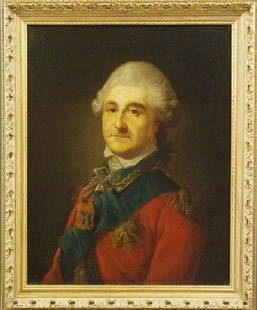
Sold201618th century portraitMarcello Bacciarelli (Attributed to) Polish/Italian, 1731-1818. Oil on canvas portrait of King Stanislaus August Poniatowski, the last King and Grand Duke of the Polish–Lithuanian Commonwealth (1764See Sold Price
Sold20218 Grand Tour Souvenir Artworks, incl. Paolo SalviatiEight (8) Grand Tour souvenir artworks on paper, including Venetian albumen print and watercolor paintings. 1st item: Paolo Salviati (Italian, 1818-1894) hand-colored albumen print depicting Saint MarSee Sold Price
Sold2017Antique Nautical Ship's Map of Atlantic Ocean, 1882Map: Track Chart Norddentsher Lloyd, Bremen Date Printed: 1882 Cartographer: Anonymous Size: 15 x 7 Condition: Good Several vertical folds as issued. Somewhat browned. Right side partially glued to caSee Sold Price
Sold2023C. BECHSTEIN ANTIQUE GRAND PIANOLate 19th century Model V empire style grand piano with gilded finishes, polished mahogany, and original ivory keys. Appears to have been refinished and internally restored. Decorative music stand. InSee Sold Price
2 days LeftJasper52Pacific Ocean sea chart. Ports lighthouses mail routes dockyards LARGE 1952 map$30
2 days LeftJasper52Pacific Ocean sea chart. Ports lighthouses mail routes dockyards LARGE 1959 map$35
2 days LeftJasper52Pacific Ocean sea chart. Ports lighthouses mail routes dockyards LARGE 1927 map$35
2 days LeftJasper52Marshall Islands North Pacific Ocean Micronesia ADMIRALTY chart 1891 (1953) map$120
2 days LeftJasper52South west Pacific Ocean Melanesia Polynesia ADMIRALTY sea chart 1875 (1968) map$120
2 days LeftJasper52Côte Nord-Est de la Nouvelle Calédonie…'. ROUBET. New Caledonia 1849 old map$180