Sold2022Antique Map Print - North America - Africa - South America - WorldSet of 4 Map Prints. Hand-colored map print of the edition of 1851 from the work Universal Historical and Geographical Atlas ("Atlas Universel Historique et Geographique"). This iconic map contains diSee Sold Price
Sold2022Antique Map Print - South Africa - Algeria - Egypt - PalestineSet of 4 Map Prints. Antique lithographic map originates from "Letts's Popular Atlas", being a series of maps delineating the whole surface of the globe, with many special and original features; and aSee Sold Price
Sold2024MAGHREB. North Africa Morocco Algeria & Tunisia. JOHNSTON 1913 old antique mapTitle: MAGHREB. North Africa Morocco Algeria & Tunisia. JOHNSTON 1913 old antique map Description: N.W. Africa Comprising Morocco, Algeria & Tunis' by W. & A.K. Johnston, Limited, Edinburgh & London (See Sold Price
Sold2023Antique Print - Cosmographia - Oruc Reis - Ottoman Corsair - Sultan of AlgiersDescription: Antique exquisite woodcut originates from the French edition of "Cosmographia" by Sebastian Münster, dating back to the 1580s. The Cosmographia is a breathtaking work of art and schoSee Sold Price
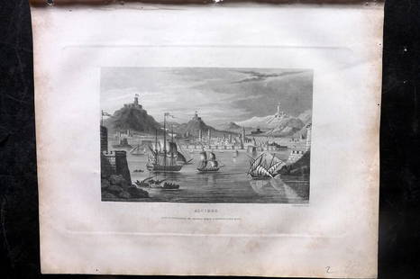
Sold2023Barclay, James 1834 Antique Print. Algiers, Ships, AlgeriaSteel Engraving Published 1834 by Thomas Kelly, London for "A New and Universal English Dictionary" by the Rev. James Barclay. Maps Drawn & Engraved by Alexander Findlay. Paper Size: 10.5 x 8 inch (27See Sold Price
Sold2021Goldsmith, J. 1852 Lot of 15 Maps and Prints6 Maps of Africa, Canaan/Palestine, Asia, Central Europe, British Isles, and Europe. Together with 9 Prints showing Astronomy, Brunei/New Zealand/Sydney, Cairo/Egypt/Algiers, New York/North American ISee Sold Price
Sold2018Roux, Joseph C1790 Antique Map of Algiers, AlgeriaCopper Engraved Map Published C1790, Paris for "Recueil Des Principaux Plans des Ports et Rades de la Mer Mediterranee" by Joseph Roux. Paper Size: 11.5 x 8.5 inch (29 x 22cm) Water stain in bottom maSee Sold Price
Sold2023Antique Map Print - Map of Africa - Madagascar - Nil - Sahara - KilimanjaroTitle: Antique Map Print - Map of Africa - Madagascar - Nil - Sahara - Kilimanjaro Date/Period: 1701 Dimensions: 6” x 5” inches / 15 cm x 13 cm Material: Paper Additional Information: A deSee Sold Price
Sold2018Colton: Antique Map of North Eastern Africa, 1859Title/Content of Map: North eastern Africa by Colton Date Printed: 1859 Cartographer: H.J. Colton Material/Medium: Paper Size: 17 1/2" X 15" Hand colored,engraved. Published in New York in 'Colton's GSee Sold Price
Sold2022Antique Map Print - Map of Africa - The Royal Atlas - Kate JohnstonMap of Africa. Kate Johnston, F.R.S.E. Engraved and printed by W. & A.K. Johnston. Prime meridian: Greenwich; Relief shown by dashes. Top left: "Keith Johnston's General Atlas." Separated from Keith JSee Sold Price
Sold2020Antique Austrian Map of North East AfricaAntique Austrian Map of North East Africa Engraving, Karte von Africa, Including Egypt and Israel 1787. Robert Vaugondy, F. A. Schraembl. Used condition. 28" x 30"See Sold Price
Sold2022Antique Map Print - Canada - North AmericaSet of 4 Map Prints. Antique lithographic map originates from "Letts's Popular Atlas", being a series of maps delineating the whole surface of the globe, with many special and original features; and aSee Sold Price
Sold2023Antique Map Print - Five West Indies - North America - South America - 1701Title: Antique Map Print - Five West Indies - North America - South America - 1701 Date/Period: 1701 Dimensions: 15 cm x 13 cm Material: Paper Additional Information: A detailed small map from ”See Sold Price
Sold2017Tallis: Antique Map of Africa, 1853Map: Africa Date Printed: 1853 Cartographer: Tallis Material/Medium: lithograph Size: 10 3/4" x 14" Original lithograph by John Tallis & Company of London, c. 1853. Map vignettes feature North AfricaSee Sold Price
Sold2022Antique Map of Africa - Nigeria - Ethiopia - Algeria - Kenya - Samuel John NeeleA new map of Africa from the best authorities, 1791. Technique: Engraving. Artist: Samuel John Neele. Place: London, England. Size: 10” x 8” inches / 25 cm x 21 cm.See Sold Price
Sold2019Maps 1824-1911 Mixed Lot of 10 Antique MapsIncl Sweden, Denmark, Norway, Macedonia/Thrace, Asia Minor, Egypt, Siberia, England/Wales, Switzerland, and North Africa. Examples by Delamarche, Barthelemy, Becker, Bryce and Encyclopaedia BritannicaSee Sold Price
Sold2024North Africa. Salt mines. Saharan explorers'/caravan routes. THOMSON 1817 mapTITLE/CONTENT OF MAP: 'North Africa' DATE PRINTED: Published in 1817. Engraved in 1815; this date is marked on the map IMAGE SIZE: Approx 29.5 x 53.0cm, 11.75 x 21 inches (Large) TYPE: Antique early 1See Sold Price
2018"North Africa". Salt mines. Saharan caravan/explorers'TITLE/CONTENT OF MAP: 'North Africa' DATE: 1817 IMAGE SIZE: Approx 30.0 x 53.0cm, 11.75 x 20.75 inches (Large) TYPE: Antique early 19th century atlas map with original hand colouring CONDITION: Good;See Sold Price
Sold2023NORTH AFRICA BARBARY. Tripoli Libya Egypt coast Alexandria Tobruk. SDUK 1874 mapTITLE/CONTENT OF MAP: 'NORTH AFRICA OR BARBARY, V., PARTS OF TRIPOLI AND EGYPT' DATE PRINTED: 1874 IMAGE SIZE: Approx 34.0 x 42.5cm, 13.25 x 16.75 inches (Large) TYPE: Antique steel engraved map withSee Sold Price
Sold2023Seutter - Map of North America including Great Lakes, Florida, Virginia, New England, Mexico, WestThis engraving is from a composite atlas presented by the Homann Heirs. Many of the maps in the collection were completed by J. B. Homann, Homann Erben, M. Seutter, and T. C. Lotter. The maps were oriSee Sold Price
Sold2023Burr - Map of North AmericaThis hand-colored map is from David H. Burr's A New Universal Atlas; comprising separate maps of all the principal empires, kingdoms & states throughout the world: and forming a distinct atlas of theSee Sold Price
Sold2023Brion - Map of North AmericaThis fine map is from Louis Brion de la Tour. It is entitled "Nouveau Mexique, Louisiane, Canada, et N.lle Angleterre." The work was published by Louis Charles Desnos in 1786. The map was first publisSee Sold Price
Sold2024Arrowsmith & Lewis - Map of North AmericaThis engraved map is from Aaron Arrowsmith & Samuel Lewis's A New and Elegant General Atlas. Comprising all the new discoveries, to the present time... The work was published in Boston in 1812 by ThomSee Sold Price
Sold2024Bonne & Desmarest - Map of AfricaThis fine map engraving is from Rigobert Bonne and Nicolas Desmarest's Atlas encyclop?dique, contenant la g?ographie ancienne, et quelques cartes sur la g?ographie du moyen age, la g?ographie moderneSee Sold Price
6 days LeftTrillium Antique Prints & Rare BooksKircher, pub. 1682 - Pair of Engravings: Map of South Africa & Three Maps to One sheet of the$80(2 bids)
3 days LeftJasper52Leeward Islands. Cuba, Hayti/Haiti or Santo Domingo, Puerto Rico. LOWRY 1859 map$110
3 days LeftJasper52Grand Bahama & Great Abaco Islands. Bahamas. ADMIRALTY sea chart 1886 (1968) map$140
3 days LeftJasper52Amér. Sep. Curacao #74. Aruba Bonaire Puerto Rico Beata. VANDERMAELEN 1827 map$140
3 days LeftJasper52The Consolidated Slave Act of Jamaica 1792. 40 pages. Bryan Edwards 1794 print$120
3 days LeftJasper52Descrittione dell' Isola Iamaica…. PORCACCHI. Jamaica 1590 old antique map$200
6 days LeftTrillium Antique Prints & Rare BooksAudubon, Imperial Folio - Pair of Rodent Lithographs$375
4 days LeftNY Elizabeth ANTIQUE MAP-ILLUSTRATED FLORAL ILLUSTRATION 1761 NEW DICTIONARY OF TRADE AND COMMERCE R. ROTH$100
Jul 06Case Antiques, Inc. Auctions & AppraisalsColton's Atlas of the World, 1856, in Two Volumes; plus Africa / Mahdist War Map$500(1 bid)