Sold2018ARCHITECTURE ET URBANISME – ETATS-UNIS (48 livres)WILLENSKY, Elliot & al. - A Guide to New York City, 3rd ed. New York, 1988. LAMBERT, Phyllis, ed. - Mies in America. Montreal, 2001. NEWPORT - Picturesque Newport, A souvenir book. 1975. - Newport ManSee Sold Price
Sold2018ARCHITECTURE ET URBANISME – ETATS-UNIS (24 livres)VIGNELLI, Massimo, ed. - Hugh Newell Jacobsen, architect. Washington, 1988. Toile et jaquette. FLOYD, Margaret Henderson. - Henry Hobson Richardson, A genius for architecture. New York, 1997. Toile etSee Sold Price
Sold2018ARCHITECTURE ET URBANISME – ETATS-UNIS (24 livres)SOROS, Susan Weber & al. - Thomas Jeckyll, architect and designer 1827-1881. New Haven, 2003. Toile et jaquette. KAYSER, Kay. - The Architecture of Gunnar Birkets. Washington, 1989. Toile et jaquette.See Sold Price
Sold2016Carte Genrale Des Etats-Unis Et Du Mexique 1862Map Title: Carte Genrale Des Etats-Unis Et Du Mexique Date: 1862 Publisher: Andriveau-Goujon: Paris Size: 24.3 x 18.25 inches Eastern sheet only. Only east of the Mississippi shown, only Yucatan shownSee Sold Price
Sold2018Engraved map of Canada and United StatesCarte de la Region Orientale des Etats-Unis et de la dominion du Canada, 19th century, engraved map with hand coloring, designed by A. Brue, overall (with frame): 19.5"h x 25"wSee Sold Price
Sold2018ARCHITECTURE ET URBANISME – Canada - ERICKSON (5ERICKSON, Arthur. - The Architecture of Arthur Erickson, with text by the architect, Montréal, 1975. Toile et jaquette. SIGNÉ. IGLAUR, Edith. - Seven Stomes : a portrait of Arthur Erickson,See Sold Price
Sold2018CART DU MEXIQUE ET DES ETATS UNIS D'AMERIQUETitle: CART DU MEXIQUE ET DES ETATS UNIS D'AMERIQUE Maker: DEZAUCHE Origin: FRANCE Date/Period: 1783 Materials: COPPER ENGRAVING Dimensions: 48X65CM UPDATED VERSION OF DE L'ISLE'S MAP ENTITLED 'CARTESee Sold Price
Sold2021Vintage Advertising Poster, Empress of ScotlandA vintage Canadian Pacific (French) advertising colour lithographic poster, depicting the Empress of Scotland at sea promoting the route "Au Canada et aux Etats-Unis par la belle voie abritée du SainSee Sold Price
Sold2023EUSTACHE-HYACINTHE LANGLOIS (1777-1837) A MEXICAN TEXAS MAP, "Etats Unis et Partie de L'AméEUSTACHE-HYACINTHE LANGLOIS (1777-1837) A MEXICAN TEXAS MAP, "Etats Unis et Partie de L'Amérique Anglaise et du Mexique," PARIS, CIRCA 1830, lithograph on cream wove paper with hand color, probabSee Sold Price
Sold20231868 Drioux and Leroy Map of the United States -- Carte Physique et Politique des Etats-Unis, CanadaTitle: 1868 Drioux and Leroy Map of the United States -- Carte Physique et Politique des Etats-Unis, Canada et Partie du Mexique Cartographer: Drioux & Leroy Year / Place: 1868 Map Dimension (in.): 11See Sold Price
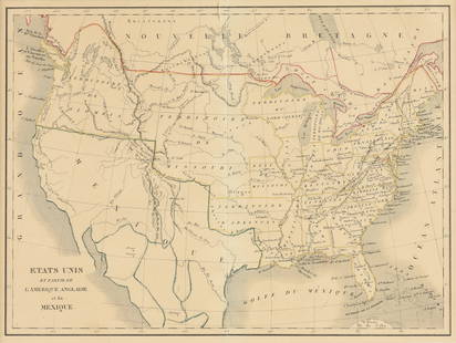
Sold2018Etats-Unis Et Nouvelle ButagneReserve Reduced! Item: Etats-Unis Et Nouvelle Butagne Date: 1848 ca. Cartographer: Antonie, Louis Publisher: Monin & Vuillemin Size (inches): 8.5X11.3 From Atlas de Geographie. Gila R. s.w. boundary bSee Sold Price
Sold2017Bonne: Antique Map of Northeastern Canada, 1783Map: Partie de l'Amerique Septentrionale qui comprend le Canada, la Louisiane, le Labrador, le Grenland, les Etats Unis, et la Floride Cartographer: Bonne Place & Date: Paris / 1783 Size: 17" x 11 5/8See Sold Price
Sold20181715 - 1789 Europe En 1715 | Inde Antilles Etats-UnisReserve Reduced! Title: 1715 - 1789 Europe En 1715 | Inde Antilles Etats-Unis Et Canada Au XVIIIme Siecle Publication Date: c1878 Cartographer: DRIOUX, CLAUDE JOSEPH/CH. LEROY Publisher: EUGENE BELINSee Sold Price
Sold2022VOLNEY, CONSTANTIN-FRANCOIS CHASSEBOEUF, comte de Tableau du climat et du sol des Etats-UnisVOLNEY, CONSTANTIN-FRANCOIS CHASSEBOEUF, comte de Tableau du climat et du sol des Etats-Unis d'Amerique. Suivi d'eclaircissemens sur la Floride, sur las colonie francaise au Scioto, sur quelques colonSee Sold Price
2020Nall, esposition de Gravures et de dessins, FondationNall, esposition de Gravures et de dessins, Fondation des Etats-Unis, 5 August-9 June 1972, offset, cm 60,5x39.See Sold Price
Sold20174 Lebanon 5-50 Livres 1952-64Lebanon Banque De Syrie Et Du Liban, 5, 10, 25, 50 Livres, 1952-64, (P.56a to 59a), serial nos. 28565 C23, 80223 A23, 40490 S25, 60365 F10 (mended), fine to good fine. (4)See Sold Price
Sold2016Tanner map of west 1852 in French pamphetHeading: Author: Tanner, Henry Schenck Title: Carte Des Nouvelle Etats et Territoires annexés aux Etats-Unis Extrait de la carte Génerale des Etats-Unis Publiée New York en 1851 par H. S. Tanner PSee Sold Price
Sold2019Two Maps by Rigobert Bonne (1727-1794, Paris), Isles deTwo Maps by Rigobert Bonne (1727-1794, Paris), Isles de Cuba et de Jamaiqe, 1750; together with Les Etats Unis de L'Amerique Septentrionale les Royale de Terre Neuve, de St. Jean et L'Acadie; et partiSee Sold Price
Sold2023Keith HARING (1958-1990), Attribué à, Etats-Unis.Keith HARING (1958-1990), Attribué à, Etats-Unis. Sans titre, circa 1989 Dessin au marqueur et gouache sur papier, signé en bas à gauche Porte le cachet « The Keith Haring EstSee Sold Price
Sold2023Keith HARING (1958-1990), Attribué à, Etats-Unis.Keith HARING (1958-1990), Attribué à, Etats-Unis. Totem,1989 Dessin au marqueur noir et gouache sur papier Signé et daté en bas à droite à l’encre (légèreSee Sold Price
Sold2019Avoc Etats Unis trunk with quilted interior cover andAvoc Etats Unis trunk with quilted interior cover and two trays, brass hardware, and handles. ht. 26 1/2 in., top: 25" x 47 1/2"See Sold Price
Sold2016Carte des Etats-Unis d'Amerique, du Canada, 1832Map: Carte des Etats-Unis d'Amerique, du Canada, du Nouveau Brunswick et d'une Partie de la Nouvelle Bretagne Cartographer: Pierre M. Lapie Publishing: Paris, 1832 Size: 16 x 20 inches Matted A greatSee Sold Price
Sold2021Lapie - Carte de Etats Unis d’Amérique du Canada, duArtist: Lapie Title: Carte de Etats Unis d’Amérique du Canada, du Nouveau Brunswick et d’une partie de la Nouvelle Bretagne Description: Lapie - Carte de Etats Unis d’Amérique du Canada, du NoSee Sold Price
Sold2016Carte Des Etats-Unis, 1856Map: Carte Des Etats-Unis Maker: Louis Etienne Dussieux Date: 1856 Size: Folio - 11 inches high x 15.25 inches wide "Grave par Marlier." U.S. map from his Atlas Generale showing unusual Western territSee Sold Price
BonhamsHERMES Paris. Cendrier en porcelaine 'Early America'. D'après le carré dessiné pa...€150
Jun 14DuMouchellesRigobert Bonne (French, 1727-1794) Hand Colored Engraving Ca. 18th Century, Les Etats Unis De$50
6 hrs LeftRapid Estate Liquidators and Auction GalleryPuissance Militaire Etats Unis D'Amerique Hardcover$90
5 days LeftArt Research ParisALESSANDRO GUERRIERO (NÉ EN 1920) & ALCHIMIA (ÉDITEUR) ALESSANDRO GUERRIERO (NE? EN 1920) &€3,000
4 days LeftBonhamsFRANCK EVENNOU (1958) Table d'appoint MangroveCréation en 2014, exemplaire de 2021Signé...€3,800
Jun 01Link Auction GalleriesHenri Matisse, French (1869-1954), Femme a l'Amphore et Grenades, color lithograph$100
BonhamsPaire de lampes. Travail moderne Laiton doré et laque noire91 x 40 x 25.5 cm (avec abat-jour)€10
1 day LeftClark's Auction CompanyL'Immortal From Grace Et Mouvement, Etching After Pablo Picasso, Signed In Plate$120
Jun 02Taylor & HarrisChristofle et Cie French Mixed Metal Copper Silver Inlay Gold Plate Candelabra$1,000
4 days LeftBonhamsGUY DE ROUGEMONT (1935-2021) ColonneCirca 1970Pièce uniquePVC peint et mélaminéH:...€2,500