20231803 Voyages in TIBET Bhutan Panchen Lama Buddhism Campe ASIA MAP Samuel Turner1803 Voyages in TIBET Bhutan Panchen Lama Buddhism Campe ASIA MAP Samuel Turner Joachim Heinrich Campe was an 18th-century German author known for his travelogues and histories of voyages. One of hisSee Sold Price
Sold2023Samuel Dunn, Map of the British Empire in North America, EngravingTitle: Map of the British Empire in North America; By Samuel Dunn, Mathematician. Artist: Samuel Dunn Publisher: London: Printed for Robt. Sayer, No. 53 in Fleet Street. Reference: Stevens & Tree, "See Sold Price
Sold2023SAMUEL DUNN NEW ATLAS MAP ENGRAVINGS LOT OF 5The North Part of Italy Comprehending the Dominions of the King of Sardinia, the Estates of Parma & Modena of Genoa, Venice and Lucca & Spain and Portugal with Their General Divisions & The Northern SSee Sold Price
Sold2017SAMUEL DUNN HAND COLORED PRINTED MAPSAMUEL DUNN, HAND COLORED PRINTED MAP, IMAGE: H 19", W 12 1/2", "A NEW MAP OF THE UNITED STATES OF NORTH AMERICA":"--- with the British Dominions on the continent"; printed for Robert Sayer; framed.See Sold Price
Sold2023Beeton, Samuel 1868 Pair of Maps. Asia & Asia MinorLithograph Maps Published 1868, London for "Beeton’s Dictionary Of Geography" by Samuel Orchart Beeton. Folds as issued. Paper Size: 10 x 8 inch (26 x 20cm) Good ConditionSee Sold Price
Sold2020A General Map of the World London 1799Samuel Dunn (d. 1794), "A General Map of the World, or Terraqueous Globe, with all the New Discoveries and Marginal Delineations, Containing the Most Interesting Particulars in the Solar, Starry and MSee Sold Price
Sold20241794 RUSSIA DIVIDED INTO ITS GOVERNMENTS antique MAP 18 x 22"RUSSIA DIVIDED INTO ITS GOVERNMENTS by SAMUEL DUNN c. 1794 Size overall 18 x 22 in. 100% original Very good condition Reserve: $75.00 Shipping: Domestic: Flat-rate of $25.00 to anywhere within theSee Sold Price
Sold2022Cellarius & Patrick 1816 Map. Asia cis TaurumCopper Engraved Map Published 1816, London for "Geographia Antiqua" by Samuel Patrick. Maps based on those by Andreas Cellarius. Folds as issued. Paper Size: 10 x 8 inch (26 x 20cm) Closed splits on fSee Sold Price
Sold2017Mitchell: Map of Russia in Asia and Tartary, 1846Map: Russia in Asia and Tartary Publication Date: 1846 Maker: H.N. BURROUGHS, TANNER, HENRY SCHENK/SAMUEL AUGUSTUS MITCHELL Publisher: H.N. BURROUGHS Size: Quarto – 11.25 H x 14.25 W Inches With insSee Sold Price
Sold2017Mitchell, Thomas, Cowperthrait: Map of Turkey in AsiaTitle: Map of Turkey in Asia by Mitchell, Thomas, Cowperthrait Date: 1854 Dimensions: 17 x 14 Medium: Hand Colored Lithograph Samuel Augustus Mitchell (1790-1860) was an American geographer born in CoSee Sold Price
Sold2020Geology 1833-64 Lot of 6 Maps and PrintsMaps mosly of Europe and British Isles but one plate showing Asia/Mexico/Holy Land. Copper Engraved Maps Published 1817-45, London for "Encyclopaedia Metropolitana" by Samuel Taylor Coleridge el al anSee Sold Price
Sold2017Mitchell: Map of Persia Arabia Turkey in Asia, 1874Map: Map of Persia, Arabia, Turkey in Asia, Afghanistan, Beloochistan. Publication Date: 1874 Authors: S. Augustus Mitchell, Jr., MITCHELL, SAMUEL AUGUSTUS (JR.) Publisher: S. Augustus Mitchell, Jr. SSee Sold Price
Sold2016Tennessee Map, Samuel Lewis & Alexander Lawson, 1804"Tennessee" Map, drawn by Samuel Lewis, engraved by Alexander Lawson, published by John Conrad & Co., Philadelphia, 1804. From "A New And Elegant General Atlas: Comprising All the New Discoveries, toSee Sold Price
Sold2023Samuel Dunn (1723 - 1794), The Principal Fixed Stars...1774"The Principal Fixed Stars of the North Hemisphere Delineated on the Plane of the Equator for the Year 1774", published in 1794 by Laurie and Whittle, London. Dimensions:Sight is 14 3/4" x 21 3/4", thSee Sold Price
Sold2022Antique Map of Asia - Map of Northern India - Dabhol - Rigobert BonneTitle: Antique Map of Asia - Map of Northern India - Dabhol - Rigobert Bonne Date/Period: 1780 Dimension: 23 cm x 36 cm Material: Paper Additional Information: Antique map of northern India. Covers thSee Sold Price
Sold2017Reichard: Ottoman Empire in Asia Map, 1820Map: Ottoman Empire in Asia Map, "Charte des Osmanischen Reichs in Asien" Cartographer: Reichard Place & Date: Weimar / 1820 Size: 24 3/4" x 19" Condition: light overall age toning; an occasional spotSee Sold Price
Sold20241860 Mitchell Map of Asia -- Map of Asia Showing its Gt. Political Divisions?Title: 1860 Mitchell Map of Asia -- Map of Asia Showing its Gt. Political Divisions? Cartographer: S Mitchell Year / Place: 1860, Philadelphia Map Dimension (in.): 10.5 x 13.5 in. A magnificent map ofSee Sold Price
Sold20201860 Mitchell Map of Asia -- Map of Asia Showing itsTitle/Content of Map: 1860 Mitchell Map of Asia -- Map of Asia Showing its Gt. Political DivisionsÂ… Cartographer: S Mitchell Year/Place: 1860, Philadelphia Size: 10.5 x 13.5 in. A magnificent mapSee Sold Price
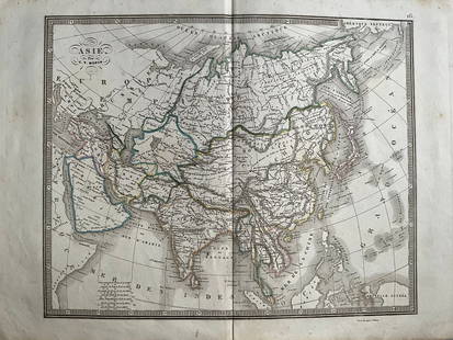
20241839 Asia Map by MoninTitle: 1839 Asia Map by Monin Date/Period: 1839 Materials: Hand colored, engraved Size: 17 1/2 x 12 1/2" This map is an interesting depiction of Asia in 1839 when the continent was still largely unexpSee Sold Price
Sold20181860 Mitchell Map od Asia -- Map of Asia Showing itsTitle/Content of Map: 1860 Mitchell Map od Asia -- Map of Asia Showing its Gt. Political Divisions… Date Printed: 1860, Philadelphia Cartographer: S Mitchell Size: 10.5 x 13.5 in. A magnificent mapSee Sold Price
Sold20211860 Mitchell Map od Asia -- Map of Asia Showing itsTitle: 1860 Mitchell Map od Asia -- Map of Asia Showing its Gt. Political Divisions… Cartographer: S Mitchell Year / Place: 1860, Philadelphia Map Dimension (in.): 10.5 x 13.5 in. A magnificent mapSee Sold Price
Sold20211895 Asia MapAuthor: Cram Title: 1895 Asia Map Medium: Ink on Paper Dimenions: 22"X15" Description: Map of Asia dated 1895. Printed by George Cram for Walker's International Atlas. Published in Chicago and New YorSee Sold Price
Sold20211865 Mitchell Map of Asia -- Map of AsiaTitle: 1865 Mitchell Map of Asia -- Map of Asia Cartographer: S Mitchell Year / Place: 1865, Philadelphia Map Dimension (in.): 8.8 X 10.6 in. This is a handsome Asia map by Mitchell, with color codedSee Sold Price
Sold20231891 Mitchell Map of Asia -- Map of Asia…Title: 1891 Mitchell Map of Asia -- Map of Asia… Cartographer: S Mitchell Year / Place: 1891, Philadelphia Map Dimension (in.): 8.2 X 10.6 in. This is an excellent map of Asia. Inset is PalestinSee Sold Price
May 30NY Elizabeth ANTIQUE MAP-ILLUSTRATED FLORAL ILLUSTRATION 1761 NEW DICTIONARY OF TRADE AND COMMERCE R. ROTH$50
Featured10 hrs LeftJasper52ASIA. Map of the Mountain Chains and the River systems of Asia 1881 old$15(1 bid)
Featured10 hrs LeftJasper52Arid Regions and Closed River Basins of Asia. Sketch map 1885 old antique$8(1 bid)
10 hrs LeftJasper52Middle East ethnic divisions. South west Asia. Sketch map 1885 old antique$8(1 bid)
10 hrs LeftJasper52H'wen-Tsang. Xuanzang itinerary. India Afghanistan Central Asia. Sketch map 1885$8
Featured10 hrs LeftJasper52Lake Khanka / Xingkai. East Asia. Sketch map 1885 old antique plan chart$8
Featured10 hrs LeftJasper52Isobars in January. Asia. Sketch map 1885 old antique vintage plan chart$8
10 hrs LeftJasper52WW2 ASIA. Japanese-occupied China Indochina Philippines. Middle East 1942 map$35(1 bid)