Sold2020Bavaria. By OrteliusTitle: Bavaria. By Ortelius Date/Period: 1570-1612 Materials: Hand colored, copperplate engraved. Dimensions: 20 1/2 x 16” From the THEATRUM ORBIS TERRARUM. The worlds first true modern Atlas PublisSee Sold Price
Sold20211602 Ortelius Map of Bavaria -- Palatinatus BavariaeTitle: 1602 Ortelius Map of Bavaria -- Palatinatus Bavariae Cartographer: A Ortelius Year / Place: 1602, Antwerp Map Dimension (in.): 3 X 4.1 in. This is a lovely map of Bavaria. This map, with northSee Sold Price
Sold20221592 map of Iceland with monsters, Abraham Ortelius1592 map of Iceland with monsters, Abraham Ortelius from Theatre of the WorldNew photos uploaded on 4/18Plate size: 19.5" x 13.25"See Sold Price
Sold2021Albert Bierstadt, "Konigsee, Bavaria", Oil on CanvasAlbert Bierstadt (German-American, 1830-1902), "Konigsee, Bavaria", oil on canvas, 19 1/4" x 26 3/4" view and 28" x 35 3/4" framed. Provenance: Los Angeles, California estate.See Sold Price
Sold2022Petrus Kaerius and Abraham Ortelius, Two Vintage MapsPETRUS KAERIUS and ABRAHAM ORTELIUS (Flemish, 1571-1646), and (Belgian, 1527-1598), Orbis Terrarum Typus De Integro Multis In Locis Emendatus auctore Petro Kaerio anno 1607, and Indiae Orientalis InsuSee Sold Price
Sold2022Ortelius, Abraham Islandia [Iceland]Ortelius, Abraham Islandia [Iceland] [Antwerp, c.1590 or later]. Hand-coloured engraved map (platemark 33.5 x 48.5cm, sheet size 43.5 x 55.5cm), incorporating sea-monsters, polar bears and Hekla volcaSee Sold Price
Sold2022Schäffer, Jacob Christian Fungorum qui in Bavaria et Palatinatu circa Ratisbonam nascunturBotanik - Mykologie Schäffer, Jacob Christian Fungorum qui in Bavaria et Palatinatu circa Ratisbonam nascuntur icones nativis coloribus expressae. Editio nova commentario aucta a C. H. Persoon. 4See Sold Price
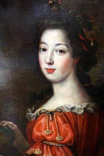
Sold2015MARIE CHRISTINE DE BAVARIA BY PIERRE MIGNARD 42X57French Baroque portrait of Duchess Maria Anna Christine Victoria of Bavaria as Ceres by French artist Pierre Mignard. Pierre Mignard, also known as "Le Romain", was a court artist and well known artisSee Sold Price
Sold2018Ortelius' 1570 world mapHeading: Author: Ortelius, Abraham Title: Typus Orbis Terrarum Place Published: Antwerp Publisher: Date Published: 1570-[1584?] Description: Copper-engraved map, hand-colorSee Sold Price
Sold2022ORTELIUS, ABRAHAM. Typus Orbis Terrarum.ORTELIUS, ABRAHAM. Typus Orbis Terrarum. Double-page engraved map of the world. 16¾x20½ inches sheet size, wide margins, Dutch text on verso; original hand-color; professionally conserved wiSee Sold Price
Sold2022ORTELIUS, ABRAHAM. Americae Sive Novi Orbis, Nova Descriptio.ORTELIUS, ABRAHAM. Americae Sive Novi Orbis, Nova Descriptio. Double-page engraved map of the Western Hemisphere. 17½x22¼ inches sheet size, wide margins, Spanish text on verso; uncolored; cSee Sold Price
Sold2017Ortelius: Antique Map of the World, 1587Map: World Date Printed: 1587-1612 Cartographer: Abraham Ortelius Material/Medium: Paper Size: *** Approx 16" x 21" Original hand color. Copperplate engraved.One of the most famous and iconic world maSee Sold Price
Sold2024Abraham Ortelius (Belgian 1527 - 1598)Abraham Ortelius (Belgian 1527 - 1598) "Maris Pacifici", circa 1603 Hand Colored map engraving of the Pacific Ocean 14" x 20" Condition: aging, yellowing to paper, undulation, center folds, some fadinSee Sold Price
Sold2022China.- Ortelius (Abraham) Chinae, olim Sinarum regionis, nova descriptio, 1584 [but slightlyChina.- Ortelius (Abraham) Chinae, olim Sinarum regionis, nova descriptio, detailed map centred on China and based on the work of Jorge de Barbuda, a Portuguese Jesuit also known as Ludovicus GeorgiusSee Sold Price
Sold2023ORTELIUS, Abraham (1527-1598). Americae sive Novi Orbis, Nova Descriptio. Antwerp, ca 1572.ORTELIUS, Abraham (1527-1598). Americae sive Novi Orbis, Nova Descriptio. Antwerp, ca 1572. Engraved map of the Americas with hand-coloring in wash and outline, visible area 15 3/4 x 20 3/4 inches (40See Sold Price
Sold2022ORTELIUS, ABRAHAM. 1527-1598. Chinae olim Sinarum regionis. Antwerp: 1584 (but c.1592).ORTELIUS, ABRAHAM. 1527-1598. Chinae olim Sinarum regionis. Antwerp: 1584 (but c.1592). Engraved map with hand-coloring. 407 x 553 mm, on one folio leaf, folded at center, extracted from atlas, with tSee Sold Price
Sold2016Celebrated 16th Century World Map by Abraham OrteliusTypvs Orbis Terrarvum, Antwerp, dated 1587, with hand-coloring; Spanish text on the back credits the cartographer's sources in this updated edition showing the Solomon Islands and a corrected South AmSee Sold Price
Sold2016Ortelius map of East Indies 1570Heading: Author: Ortelius, Abraham Title: Indiae Orientalis Insularumque Adjacientium Typus Place Published: [Antwerp] Publisher: Date Published: 1570- Description: Copper-engraSee Sold Price
Sold2024Abraham Ortelius (Belgian 1527 - 1598)Abraham Ortelius (Belgian 1527 - 1598) "Americae Sive Novi Orbis, Nova Descriptio", circa 1602 Copper engraved hand colored map of the Western Hemisphere 15" x 20" Condition: aging, yellowing to paperSee Sold Price
Sold2022Abraham Ortelius and Theodore de Bry, Two Vintage MapsABRAHAM ORTELIUS and THEODORE DE BRY (Belgian, 1527-1598), (German, 1528 - 1598), Maris Pacifici quod vulgo Mar del Zud, 1601, and Hispaniae Novae Sive Magnae, Recens et Vera Descriptio, 1595, two vinSee Sold Price
Sold2022Unknown painter, Portrait of Charles Albrecht of Bavaria from the House of Wittelsbach (1697-1745)Unknown painter Portrait of Charles Albrecht of Bavaria from the House of Wittelsbach (1697-1745) Oil on canvas 79 x 62,5 cm, with frame 90 x 74 cmSee Sold Price
Sold2022Ortelius 16th Cent. ''Americae Siv Novi Orbis' MapAbraham Ortelius 16th Cent. ''Americae Siv Novi Orbis Nova Descriptio'' Map Engraving. Hand tinted Western Hemisphere map of America circa 1570-73, printed in Antwerp. Gallery framed with glass on botSee Sold Price
Sold2024Abraham Ortelius, Map of ChinaAbraham Ortelius (Dutch, 1527-1598), "Chinae, olim Sinarum regionis nova descriptio. auctore Ludouico Georgio", hand-colored engraving. Creases. Sight size: 15"h x 19"w Overall: 22-1/2"h x 26-1/2"w PrSee Sold Price
Sold2017Ortelius: First Map of Japan in European Atlas, 1595Title: Iaponiae Insulae Descriptio. Ludoico Teisera Auctore. [first map of Japan published in European atlas] Map maker: Abraham Ortelius, Theatrum Orbis Terrarum Place and Year: Antwerp, 1595 DimensiSee Sold Price
May 16DuMouchellesSchumann Bavaria (German) 'Empress Dresden' Porcelain Breakfast Service, W 8.5" L 11.75" 122 pcs$300
May 16DuMouchellesSchumann Bavaria (German) 'Chateau Dresden' Pierced Porcelain Service Ware, Ca. 1940, 74 pcs$150
5 days LeftHunt and Peck Estate Services, Inc.Abraham Ortelius Map Middle East "Turcici Imperii Descriptio"$240(1 bid)
4 days LeftThe Benefit Shop Foundation Inc.29 HAVILAND Bavaria Gilt Porcelain Dishes, Germany$10(2 bids)
5 days LeftHunt and Peck Estate Services, Inc.Abraham Ortelius Map Of Fezza And Morocco Kingdom Of Africa Celeberrima$100
5 days LeftHunt and Peck Estate Services, Inc.Abraham Ortelius Map Middle East "Turcici Imperii Descriptio"$140
5 days LeftHunt and Peck Estate Services, Inc.Abraham Ortelius map of Bitiurigum from Theatrum Orbis Terrarum$50
1 hr LeftAuction WallstreetAntique Rosenthal Bavaria Singing Crocodile with guitar and Frog collecting money Porcelain Germany$475
3 days LeftHermann Historica GmbHKing Ludwig II of Bavaria - a gift ring with crowned name cypher "L", circa 1880€1,600
1 hr LeftAuction WallstreetLot of antique LARGE serving plates SHUMAN BAVARIA SOHO POTTERY ENGLAND$40


![Ortelius, Abraham Islandia [Iceland]: Ortelius, Abraham Islandia [Iceland] [Antwerp, c.1590 or later]. Hand-coloured engraved map (platemark 33.5 x 48.5cm, sheet size 43.5 x 55.5cm), incorporating sea-monsters, polar bears and Hekla volca](https://p1.liveauctioneers.com/94/251108/130828919_1_x.jpg?height=310&quality=70&version=1655281539)

![Ortelius' 1570 world map: Heading: Author: Ortelius, Abraham Title: Typus Orbis Terrarum Place Published: Antwerp Publisher: Date Published: 1570-[1584?] Description: Copper-engraved map, hand-color](https://p1.liveauctioneers.com/642/127929/65081054_1_x.jpg?height=310&quality=70&version=1537227236)


![Ortelius map of East Indies 1570: Heading: Author: Ortelius, Abraham Title: Indiae Orientalis Insularumque Adjacientium Typus Place Published: [Antwerp] Publisher: Date Published: 1570- Description: Copper-engra](https://p1.liveauctioneers.com/642/86438/44449716_1_x.jpg?height=310&quality=70&version=1458591928)


![Ortelius: First Map of Japan in European Atlas, 1595: Title: Iaponiae Insulae Descriptio. Ludoico Teisera Auctore. [first map of Japan published in European atlas] Map maker: Abraham Ortelius, Theatrum Orbis Terrarum Place and Year: Antwerp, 1595 Dimensi](https://p1.liveauctioneers.com/5584/108292/55552479_1_x.jpg?height=310&quality=70&version=1503667951)


