Sold2021Boating maps, royal island harbor, egg islands, currentMaps from 1981 tropic Isle publishers, Inc By Harry Kline, Royal island harbor, egg Islands, current island Anchorage. Size 11“ x 17“See Sold Price
Sold2021Boating maps, Spanish wells to Harbor Island, cays toMaps from 1981 tropic Isle publishers, Inc By Harry Kline, Spanish wells to Harbor Island, cays to Eleuthera, current cut and current settlement. Size 11“ x 17“See Sold Price
Sold2021Boating maps, harbors creeks cat Island, Turks andMaps from 1981 tropic Isle publishers, Inc By Harry Kline, Harbors creeks cat Island, Turks end Caicos Islands. 11“ x 17“See Sold Price
Sold2021Boating Maps, Long Island, Long Island north end, eastMaps from 1981 tropic Isle publishers, Inc. by Harry Klein, Long Island, Long Island Northwynn, East Coast harbors. Size, 11” x17”See Sold Price
Sold2021Boating maps, Nassau Harbour, New Providence Island,Maps from 1981 tropic Isle publishers, Inc By Harry Kline, Nassau Harbour, new Providence Island, Little Harbor and alder cay anchorages. Size 11“ x 17“See Sold Price
Sold2017Mitchell: Antique Map of Palestine, 18481861 Johnson’s China. Lovely map of China with original hand coloring. Features two insets: Harbor & Island of Amoy, and Map of Canton and Adjacent Islands. Very clean with good impression. From theSee Sold Price
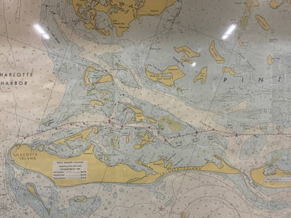
Sold2024Vintage Framed Pine Island & Lacoste Island MapVintage full color paper map, marked on top Pine island, Charlotte harbor and Lacosta island. Showing waterways and directions. Framed in a wooden frame. Approx 14 x 18 inches window measures 11.5 x 1See Sold Price
Sold2022Topographical Maps of Vineyard Nantucket Sound, StTopographical Maps of Vineyard Nantucket Sound, St Joseph Sound, Cape Cod Bay, Medield, and Massachusetts Harbor Islands. Group of 6 Mid Century Geological Survey maps. Largest 23 x 27 inches. Small eSee Sold Price
Sold2021Boating maps, crooked island district, little SanMaps from 1981 tropic Isle publishers, Inc By Harry Kline, Crooked island district, little San Salvador little island or little cat island, cat island and little San Salvador. Size 11“ x 17̶See Sold Price
Sold2023MAP: United States - East Coast/ Rhode Island/ PROVIDENCE HARBORDescription: United States - East Coast/ Rhode Island/ PROVIDENCE HARBOR. Published at Washington D. C. Jan 1945 (25th edition). US COAST AND GEODETIC SURVEY.Material: PaperMeasurement approximate: 24See Sold Price
Sold2021Boating maps, Southern Berry islands, Central BerryMaps from 1981 tropic Isle publishers, Inc By Harry Kline, Southern Berry Islands, Central Berry islands, Northern Berry islands. Size 11“ x 17“See Sold Price
Sold2019Three Maps from the Hydrographic Office U. S. Navy, theThree Maps from the Hydrographic Office U. S. Navy, the first "North Pacific Ocean, Caroline Islands, North Coast of Ponape Island, Ponape Harbor to Talak Passage," 1944, H. -30 in., W. -42 in.; withSee Sold Price
Sold2017Hawaiian Islands Map, George Cram, 1905Hawaiian Islands. George Cram. 1895. Map showing placenames, roads, elevations of mtns. points, bays, etc. Inset: Harbor of Honolulu Island of Oahu. Please note that this lot has a confidential reservSee Sold Price
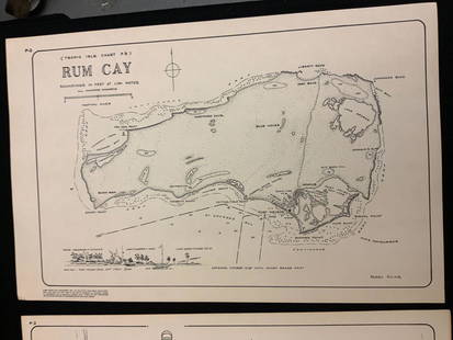
Sold2021Boating maps, rum cay, conception island, San Salvador.Maps from 1981 tropic Isle publishers, Inc By Harry Kline, Rum Cay, Conception island, San Salvador. Size 11“ x 17“See Sold Price
Sold2021Boating Maps, Bahamas for out islands, The BahamaMaps from 1981 tropic Isle publishers, Inc By Harry Klein, Bahamas far out islands, The Bahama Islands, airstrip locations.See Sold Price
Sold2023MAP: United States - East Coast. Thames River New York London Harbor Long Island to NorwichDescription: United States - East Coast Connecticut - New York. Thames River/ New York London Harbor Long Island to Norwich. Published at Washington D.C. US Department of Commerce, Environmental ScienSee Sold Price
Sold2021Boating maps, western New Providence, rose island,Maps from 1981 tropic Isle publishers, Inc By Harry Kline, Western New Providence, rose Island, eastern approaches to Nassau harbour. Size 11“ x 17“See Sold Price
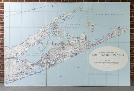
Sold2022Three Panel Water Current Map of Eastern Long Island on Canvas with FrameOver scaled Eastern Long Island water current map on three panel canvas, strengthened on frame. Please note of wear consistent with age. Each panel measures 48"W x 2"D x 96"H.See Sold Price
Sold2020Bellin: Isla del Carmen (Port Royal Island), MexicoTitle/Content of Map: Bellin: Isla del Carmen (Port Royal Island), Mexico Date Printed: 1760, Leipzig Cartographer: Bellin Size: 5 7/8" x 7 7/8" A lovely exemplar of Bellin's chart of the island of PoSee Sold Price
Sold2023Antique Map of Yerba Buena Island, CaliforniaMap Of Yerba Buena Island, San Francisco. Marked: "Yerba Buena Island San Francisco Harbor, Cal, AM. Photo Lithographic Co. N.Y. (Osborne's Process)" Approximately 22.0L x 24.0W inSee Sold Price
Sold2021Boating maps, the Jumentos Cays end drag at IslandMaps from 1981 tropic Isle publishers, Inc By Harry Kline, The Jumentos Cays in Ragan Island harbour, French wells and turtle sound, crooked Acklins islands. Size 11“ x 17“See Sold Price
Sold20231840 Maps of the Pacific IslandsVITI Group for Feejee Islands. 26" x 29 1/2", M'BUA or Sandlewood Bay Island of Vanua Levu 20" x 26", Whippy Harbour, Sura Harbor, Granby Harbor & Ndrongga Harbor 26" x 20", Muthuata Island to Ivaca PSee Sold Price
Sold2021Boating maps, Powell Point to rock sound, EleutheraMaps from 1981 tropic Isle publishers, Inc By Harry Kline, Powell point to rock sound, Eleuthera island, Spanish wells and ridley head channel. Size 11“ x 17“See Sold Price
Sold2024Map of United States of North America, 1785Map of United States of North America, 1785, The Royal Islands of Newfoundland. 26 3/4 x 32 3/4 in framed. 19 x 25 in unframed.Local Pick up call one day before to make an appointment. TO SHIP THIS ITSee Sold Price
2 days LeftHunt and Peck Estate Services, Inc.Nathaniel Blackmore "The Harbour of Annapolis Royal"$50(1 bid)
Featured14 hrs LeftJasper521756 The Remote Chilean Juan Fernandez Archipelago, Eastern Robinson Crusoe Island, by G. Anson$20(1 bid)
2 days LeftJasper52Jamaica. Kingston Port Royal Bluefields/Savanna-la-Mar inset. THOMSON 1830 map$100
2 days LeftJasper52Central America Caribbean Gulf of Mexico chart Ports lighthouses LARGE 1918 map$45
14 hrs LeftJasper521822 Carey & Lea Map of Massachusetts -- Geographical, Historical, and Statistical Map of$85
9 hrs LeftJohn Moran Auctioneers, Inc.Franz A. Bischoff (1864-1929), "Santa Rosa Island [at] San Pedro Harbor"$3,000
4 days LeftTrillium Antique Prints & Rare BooksWilkes - 3 Maps of Australian, Samoan or Navigator Islands, & Island of Tahiti$100
2 days LeftJasper52Cuba, the Bahamas & Bermuda "or Summer Islands". Turks & Caicos THOMSON 1830 map$160
Featured2 days LeftJasper52The Bahamas, Cuba & Bermuda "or Summer Islands". THOMSON 1817 old antique map$180
May 14Akiba Galleries(2 Pc) Allain Manesson Mallet Description De L'Univers 2 Vol. German Translation$200(1 bid)
May 14Dempsey AuctionsRobert Charles Gruppe, Oil on Canvas, Ten Pound Island Lighthouse, Gloucester Harbor Painting$500
May 15University ArchivesStatue of Liberty Inaugural Ceremony Invitation, October 28, 1886$300(1 bid)


![Franz A. Bischoff (1864-1929), "Santa Rosa Island [at] San Pedro Harbor" (1 of 7)](https://p1.liveauctioneers.com/255/326746/175936481_1_x.jpg?height=282&quality=70&version=1713412391)


