Sold2022Nat. Encyclo. C1875 Map. Plan of Athens, GreeceWoodblock Published C1868-81 by William Mackenzie, London for "The National Encyclopedia: A dictionary of Universal Knowledge" Folds as issued. Paper Size: 13.5 x 9.5 inch (34 x 24cm) Minor toning, otSee Sold Price
Sold2022National Encyclopedia C1875 Map. World HemispheresLithograph Map Published C1868-81 by William Mackenzie, London for "The National Encyclopedia: A dictionary of Universal Knowledge" Centre fold as issued. Paper Size: 12.5 x 9.5 inch (32 x 24cm) GoodSee Sold Price
Sold2022Nat. Encyclo. C1875 Map. World HemispheresLithograph Map Published C1868-81 by William Mackenzie, London for "The National Encyclopedia: A dictionary of Universal Knowledge" Centre Fold as issued. Paper Size: 12 x 9.5 inch (31 x 24cm) Good CoSee Sold Price
Sold2022National Encyclopedia C1875 Map of Athens, GreeceWoodblock Published C1868-81 by William Mackenzie, London for "The National Encyclopedia: A dictionary of Universal Knowledge" Folds as issued. Paper Size: 12 x 9.5 inch (31 x 24cm) Good ConditionSee Sold Price
Sold2022National Encyclopedia C1875 Plan & View of the Forum, Rome ItalyWoodblocks Published C1868-81 by William Mackenzie, London for "The National Encyclopedia: A dictionary of Universal Knowledge" Centre fold as issued. Paper Size: 12 x 9.5 inch (31 x 24cm) Good ConditSee Sold Price
Sold2022National Encyclopedia C1875 Map. AfricaLithograph Map Published C1868-81 by William Mackenzie, London for "The National Encyclopedia: A dictionary of Universal Knowledge" Centre fold as issued. Paper Size: 12 x 9.5 inch (31 x 24cm) Good CoSee Sold Price
Sold2022National Encyclopedia C1875 Map of Athens, GreeceWoodblock Published C1868-81 by William Mackenzie, London for "The National Encyclopedia: A dictionary of Universal Knowledge" Folds as issued. Paper Size: 13 x 9.5 inch (33 x 24cm) Good ConditionSee Sold Price
Sold2022Nat. Encyclo. C1875 Map. North Polar RegionsLithograph Map Published C1868-81 by William Mackenzie, London for "The National Encyclopedia: A dictionary of Universal Knowledge" Centre Fold as issued. Paper Size: 12 x 9.5 inch (31 x 24cm) Good CoSee Sold Price
Sold2022Nat. Encyclo. C1875 Celestial Map. The SeasonsLithograph Map Published C1868-81 by William Mackenzie, London for "The National Encyclopedia: A dictionary of Universal Knowledge" Centre Fold as issued. Paper Size: 12 x 9.5 inch (31 x 24cm) Good CoSee Sold Price
Sold2022National Encyclopedia C1875 LG Map. World on MercatorLithograph Map C1868-81 by William Mackenzie, London for "The National Encyclopedia: A dictionary of Universal Knowledge" Folds as issued. Paper Size: 20.5 x 13.5 inch (52 x 34cm) Good ConditionSee Sold Price
Sold2022National Encyclopedia C1875 Antique Map. CyprusLithograph Map C1868-81 by William Mackenzie, London for "The National Encyclopedia: A dictionary of Universal Knowledge" Paper Size: 9.5 x 6.5 inch (24 x 16.5cm) Good ConditionSee Sold Price
Sold2022Nat. Encyclo. C1875 Pair Maps. Australia & New ZealandLithograph Map Published C1868-81 by William Mackenzie, London for "The National Encyclopedia: A dictionary of Universal Knowledge" Centre Fold as issued. Paper Size: 12 x 9.5 inch (31 x 24cm) Good CoSee Sold Price
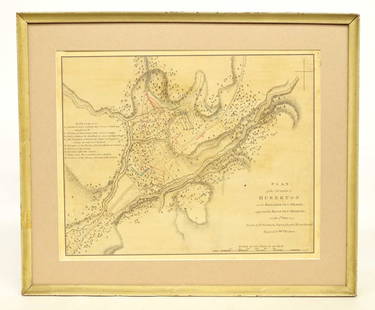
Sold202018th c. Battle Map18th c. Battle map "PLAN / of the ACTION of / HUBERTON...July 1777". Sight 11" x 13 1/2".See Sold Price
Sold2022Nat. Encyclo. C1875 Celestial. Constellations MapWoodblock Published C1868-81 by William Mackenzie, London for "The National Encyclopedia: A dictionary of Universal Knowledge" Folds as issued. Paper Size: 17 x 9.5 inch (43 x 24cm) Good ConditionSee Sold Price
Sold2023Blackie (Pub) C1875 Astronomy Celestial Map. The Solar SystemLithograph Map Published 1837-1893 by Blackie & Son, London for "The Popular Encyclopedia; or, Conversations Lexicon" Centre fold as issued. Paper Size: 12.5 x 9.5 inch (30 x 24cm) Good ConditionSee Sold Price
Sold2022National Encyclopedia C1875 Pair of Maps of Rome ItalyWoodblocks Published C1868-81 by William Mackenzie, London for "The National Encyclopedia: A dictionary of Universal Knowledge" Centre fold as issued. Paper Size: 12 x 9.5 inch (31 x 24cm) Good ConditSee Sold Price
Sold20241875 Smith Map of Africa -- Map of AfricaTitle: 1875 Smith Map of Africa -- Map of Africa Cartographer: J Smith Co. Year / Place: 1875 c. Map Dimension (in.): 8.8 X 107 in. This is an excellent map of Africa, illustrating the rapid but not cSee Sold Price
Sold2022Nat. Encyclo. C1875 Lot of 5 Maps - AmericasIncl East and West USA, North America, South America and Canada. Lithograph Map Published C1868-81 by William Mackenzie, London for "The National Encyclopedia: A dictionary of Universal Knowledge"CentSee Sold Price
Sold2022National Encyclopedia C1875 Pair of Tide MapsLithograph Map C1868-81 by William Mackenzie, London for "The National Encyclopedia: A dictionary of Universal Knowledge" Folds as issued. Paper Size: Up to 19 x 9.5 inch (48 x 24cm) Good ConditionSee Sold Price
Sold2022Nat. Encyclo. C1875 Lot of 5 Maps - AsiaIncl China, Turkey in Asia, Asia Continent, North and South India. Lithograph Map Published C1868-81 by William Mackenzie, London for "The National Encyclopedia: A dictionary of Universal Knowledge" CSee Sold Price
Sold2022Nat. Encyclo. C1875 Lot of 5 Maps - UK & IrelandLithograph Map Published C1868-81 by William Mackenzie, London for "The National Encyclopedia: A dictionary of Universal Knowledge" Centre Fold as issued. Paper Size: 12 x 9.5 inch (31 x 24cm) Good CoSee Sold Price
Sold2019France C1840-75 Pair of Large Hand Colored Maps"Carte Compare la Gaule" Large Hand Coloured Steel Engraved Map Published C1875, Paris for "Atlas Universel" by Eugène Andriveau-Goujon. Together with one other by Goujon, "France Historique" From AtSee Sold Price
Sold2018Bellin: Antique Map of New Orleans, 1827Title/Content of Map: 1827 c. Bellin Map of New Orleans -- Plan de la Nouvelle-Orleans sur les Manuscrits du Depot des Cartes de la Marine Date Printed: 1827 c., Paris Cartographer: J Bellin Size: 7.4See Sold Price
Sold2019Atlas C1875 Philips' & Hughes Classical Atlas, 18 Maps"Philips' Hand Classical Atlas" by William Hughes. London: George Philip, nd C1875. 8vo (215 x 155mm) Complete with 18 Lithograph Maps. Red cloth with slight wear. Previous owners inscription on frontSee Sold Price
Featured6 days LeftJasper52Johnson's New Military Map of the United States Showing the Forts, Military Posts &C. With Enlarged$65
6 days LeftJasper52c1863 Civil War era Virginia with Washington D.C. and View of The Capital. By C. Magnus$220