Sold20212 U.S. Coast Survey Maps, Catalina Harbor & West CoastLot of two U.S. Coast Survey Maps to include: Catalina Harbor, "1852" and Reconnaissance of the Western Coast of the United States, middle sheet, from San Francisco to the Umpquah River, "1854," frameSee Sold Price
Sold2017Nautical Coastal Map of San Clemente Harbor, 1852Map: 1852 US Coast Guard Nautical Chart and Coastal Map of San Clemente Harbor California -- Reconnaissance of San Clemente Harbor, CA and Reconnaissance of Prisoners's Harbor and Cuyler's harbor andSee Sold Price
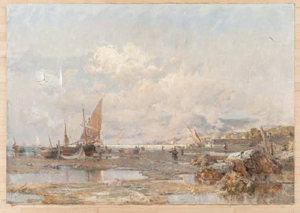
Sold2021Granville Redmond (American, 1871-1935)Granville Redmond (American, 1871-1935) Catalina Harbor Signed "Granville Redmond" l.l., signed and dated "Granville Redmond/1920" on the reverse, identified on a label from Kerwin GallerieSee Sold Price
Sold20171852 Edmond Friese Volinist, J.S. Bach1852, Edmond Friese Volinist, Violin Etuden Von Mazas, Kreudzen, Fiorello, J.S. Bach. 1852, Seven scores, published by different houses, bound in one folio size binding. Extensive notes by Edmund FrieSee Sold Price
Sold2024GEORGE M. HATHAWAY (1852 - 1903). MAINE HARBOR SCENE.Oil on board, 6.25 x 10.5 inches, signed lower right. Framed, 9 x 13 inches.See Sold Price
Sold20191852 map of Monterey Harbor, U. S. Coast SurveyDetailed hand-colored map of the Monterey coast in 1852. Very clean and bright with extremely light toning at vertical fold. Excellent example. Very short separation at top and bottom centerfold. FoldSee Sold Price
Sold2023Robert Weir Allan, Four Town Views(Scottish, 1852-1942) Three coastal harbor vIews, one town street, each signed "Robert W. Allan", watercolors on paper, largest sight 14-1/8 x 20 in.; matching original Arts and Crafts carved and giltSee Sold Price
Sold2021Gilbert T. Margeson (1852-1949) Boats in RockportGilbert T. Margeson (1852-1949) Boats in Rockport Harbor oil on canvas board, 11 x 14 in., signedSee Sold Price
Sold2017Prosper Louis Senat (American 1852-1925)Prosper Louis Senat (American 1852-1925), oil on canvas French harbor scene of Ajaccio, signed lower left and dated 1892, 62'' x 88''.See Sold Price
Sold20151845 U.S. Coastal Survey Print NY Bay and HarborU.S. Coastal Survey Print, Map of New York Bay and Harbor and the Environs, published 1845, A.D. Bache Superintendent, overall 30-1/2 x 38-1/2""See Sold Price
Sold2022Impressionist Landscape Harbor Original Oil on CanvasArtist: Unknown Title: Gondola At Rest Medium: Original Oil on Canvas Art Dimensions: 24 H x 36 W inches Framed Dimensions: 33 H x 45 W inchesSee Sold Price
Sold20201853 Map of Nantucket Harbor Survey of the Coast of the1853 Map of Nantucket Harbor Survey of the Coast of the United States, "From a Trigonometrical Survey under the direction of A.D. Bache Superintedent of the Survey of the Coast of the United states. TSee Sold Price
Sold20231841 CHARLESTON, SOUTH CAROLINA HARBOR MAP1841 CHARLESTON, SOUTH CAROLINA HARBOR MAP, lithograph on paper, "Reduced from the Original Survey / of / Major H. Bache U.S.T.E." Housed under glass in a modern frame. 1841. 8" xSee Sold Price
Sold20221862 Chart of Portland Harbor.From a Trigonometrical Survey under the direction of A.D. Bache Superintendent of the Survey of the Coast of the United States. 27.5 x 25 inches, sight. Framed, 34 x 30.5 inches.See Sold Price
Sold2017Nautical Chart and Coastal Map of Monterey Bay, 1852Map: 1852 Nautical Chart and Coastal Map of Monterey Bay, California -- Monterey Harbor, CA from a Trigonometrical Survey Cartographer: US Coast Survey Year / Place: 1852 Map Dimensions: 13.1 x 11.7 iSee Sold Price
Sold20222 Watercolor Harbor ScenesTwo 19th century British watercolors on paper. Both depicting harbor scenes, one by William Henry Pearson (British, b. 1849), titled "Postel", the other by William Langley (British, 1852-1922) titledSee Sold Price
Sold2017Raoul Varin, signed engraving NY HarborRaoul Varin, signed engraving NY Harbor, Raoul Varin, (French, 1865-1943), "New York 1852", pencil signed lower right, published by A. Ackermann & Sons, NY, 18"h x 29"w (sight), 26"h x 37"w (frame sizSee Sold Price
Sold2020A.D. Bache U.S. Coast Survey Charts East CoastA. bis” A.D. Bache: [Upper Sheet] “Sketch A, Shewing the progress of the Survey in SECTION NO. 1, from 1852- 1861”. Scale 400,000. (to Passamaquoddy Bay) Published 1861. Measures 17.See Sold Price
Sold2024Perry, Matthew C. 1856 Large Map. Harbor of Hakodadi I, Yesso Id. JapanLarge Folio Lithograph Map Published 1856, Washington for "Narrative of the Expedition of an American Squadron to the China Seas and Japan, performed in the years 1852, 1853, and 1854" by Commodore MaSee Sold Price
Sold2023LUCIUS A. BRIGGSLUCIUS A. BRIGGS (American, 1852-1931), portrait of the U.S.S. Constitution in Boston Harbor, watercolor on paper, signed ''L. A. Briggs'' lower left, inscribed ''Constitution'' along bottom. Framed uSee Sold Price
Sold2022City of Portland, 1855.Lithographic image, of the 1852, J. W. Hill painting. A small edition were printed to accompany the 1855 "Reports of the CommissionersSee Sold Price
Sold2024Lucius A. Briggs(American, 1852-1931) Black Ball Liner Isaac Webb in New York Harbor, signed lower left "L.A. Briggs", partial old label verso "Isaac Webb/Briggs", watercolor on card, 17-1/2 x 22-3/4 in.; burlwood frSee Sold Price
Sold2020AN ANTIQUE SURVEY MAP, "U.S. Coast Survey: PreliminaryAN ANTIQUE SURVEY MAP, "U.S. Coast Survey: Preliminary Sketch of Galveston Bay, Texas," SECOND EDITION, CIRCA 1852, lithograph on paper, map "I, No. 2," A.D. Bache, Superintendent, "Verified by I.I.See Sold Price
6 days LeftBoston Harbor Auctions Thomas W Lawsons Polychromed Leather Nautical Panels from Dreamwold$6,500(2 bids)
6 days LeftBoston Harbor Auctions Travel Agency model of the Liberte' (former Europa) by Art Models Studio.$1,800(3 bids)
6 days LeftBoston Harbor Auctions Bull Head Spigot from Coffee Urn salvaged from the wreck of schooner Thomas W Lawson$150(1 bid)


![A.D. Bache U.S. Coast Survey Charts East Coast: A. bis” A.D. Bache: [Upper Sheet] “Sketch A, Shewing the progress of the Survey in SECTION NO. 1, from 1852- 1861”. Scale 400,000. (to Passamaquoddy Bay) Published 1861. Measures 17.](https://p1.liveauctioneers.com/3731/160211/80894976_1_x.jpg?height=310&quality=70&version=1579814385)


