Sold2022Western Mediterranean sea chart. Ports lighthouses mail routes. LARGE 1952 mapTITLE/CONTENT OF MAP: 'The Western Mediterranean; Inset Lisbon; Bordeaux; Gibraltar; Barcelona; Marseilles; Algiers; Tunis; Palermo; Genoa; Venice; Naples' DATE PRINTED: 1952 IMAGE SIZE: Approx 49.0 xSee Sold Price
Sold2024Pacific Ocean sea chart. Ports lighthouses mail routes dockyards LARGE 1918 mapTITLE/CONTENT OF MAP: 'The Pacific Ocean' DATE PRINTED: 1918 IMAGE SIZE: Approx 49.0 x 69.0cm, 19.25 x 27.25 inches (Large); Please note that this is a folding map. TYPE: Antique colour maritime map cSee Sold Price
Sold2023Pacific Ocean sea chart. Ports lighthouses mail routes dockyards LARGE 1916 mapThe Pacific Ocean' by George Philip & Son Ltd (1916). Antique colour maritime map chart; Scale 1:40,000,000, 49.0 x 69.0cm, 19.25 x 27.25 inches; Please note that this is a folding map. Description: TSee Sold Price
Sold2023Baltic Sea sea chart. Ports lighthouses mail routes dockyards. LARGE 1959 mapTITLE/CONTENT OF MAP: 'Central European states - Political' Czechoslovakia includes Carpathian Ruthenia, which it administered until it was occupied and annexed by Hungary in 1939; it was subsequentlySee Sold Price
Sold2023Eastern Europe sea chart Ports Lighthouses mail route Black Sea Baltic 1918 mapTITLE/CONTENT OF MAP: 'Eastern European Ports and Waterways' DATE PRINTED: 1918 IMAGE SIZE: Approx 49.0 x 34.0cm, 19.25 x 13.5 inches (Large) TYPE: Antique colour maritime map chart; Scale 1:20,000,00See Sold Price
Sold2024Eastern Mediterranean & Black Sea chart. Ports lighthouses mail. LARGE 1918 mapTITLE/CONTENT OF MAP: 'The Eastern Mediterranean; Inset Salonica; Odessa; Corinth Canal; The Sea of Azof; Bosphorus; Piraeus & Athens; Suez Canal; Smyrna; Alexandria; Brindisi; Valetta' DATE PRINTED:See Sold Price
Sold2024Central America Caribbean Gulf of Mexico chart Ports lighthouses LARGE 1952 mapTITLE/CONTENT OF MAP: 'Central American and West Indian Ports inset The Lesser Antilles; The Windward Passage; Bermudas; Kingston; Havana; Salina Cruz; Coatzacoalcos; Willemstad, Curacao' DATE PRINTEDSee Sold Price
Sold2018Antique Sea Chart Map of English Channel, 1914Title/Content of Map: 'The English Channel; Inset Newport; Dover; Calais; Tilbury; Brest; Cherbourg; Le Havre; Plymouth Sound; Southampton; Portsmouth; London Docks' sea chart. Ports lighthouses mailSee Sold Price
Sold2024Central America Caribbean Gulf of Mexico chart Ports lighthouses LARGE 1927 mapTITLE/CONTENT OF MAP: Central American and West Indian Ports [inset The Lesser Antilles; The Windward Passage; Bermudas; Kingston; Havana; Salina Cruz; Puerto Mexico; Mouths of the Mississippi] DATE PSee Sold Price
Sold2017Carre: Map of Sea of Japan & Korea, 1883Map: 'Carte des iles et mers du Japon, d'après les documents les plus récents' A large 19th century French sea chart of Japan, the sea of Japan, and the adjacent coast of north east Asia including tSee Sold Price
Sold2020Color pictorial map of Panama Mail Steam Ship routeHeading: (Panama Mail Steamship - color pictorial map) Author: Godwin, Harrison Title: The sea coastes of America shewing the ports of call of the Panama Mail Steamships as the country there aboutes iSee Sold Price
Sold2022LARGE ARCHITECTS PRINT / MAP / CHART CABINETFantastic very large Architectural draftsman/chart/map/print flat file - George III-Style mahogany with satinwood inlay, inset tooled leather top. 8 Drawer over 4 drawer. from the Audubon Gallery, KinSee Sold Price
Sold2024Blackie (Pub) 1882 Folio Map. Chinese Empire and JapanLithograph Map Published 1882 by Blackie & Son, London for "The Comprehensive Atlas & Geography of the World" by W. G. Blackie. Centre fold as published. Paper Size: 22 x 15 inch (56 x 38cm) Good condSee Sold Price
Sold2022Scenic Round Japanese Chinese Platter ChargerDescribed by: Nikki CNX 1168 4645 Title: Scenic Round Japanese Chinese Platter Charger Description: Lovely large scenic pattern round Japanese or Chinese platter charger. This piece shows no chips,See Sold Price
Sold2024Hokusai Katsushika: The Kazusa Sea Route Woodblock NRJapanese Woodblock Print, from the series Thirty-six Views of Mt. Fuji, the original published c.1830-2, this is a Showa era print from recarved blocks published by Watanabe with a 7mm circular publisSee Sold Price
Sold2017De Wit Portolan Sea Chart of EuropeTotius Europae Victoria... Frederic De Wit (1630-1706). Engraved map with original hand color. Amsterdam, 1675. 20 x 35 1/2 inches sheet, 27 1/2 x 43 inches framed. “The most striking and decorativeSee Sold Price
Sold2024Large Vintage Signed 18in Japanese Arita Or Chinese Scenic Landscape Jardiniere Pot Or Koi Bowl BlueProvenance: Florida Gulf Coast waterfront estate of an international traveler and yachtsman, name withheld by heirs.Description: Large Vintage Signed 18in Japanese Arita Or Chinese Scenic Landscape JaSee Sold Price
Sold2023Vanderbilt Estate Pair Monumental Chinese Qing or Japanese Meiji Lotus Bronze Urns 43 x 56 InchesThree images added 7.16, scroll through 12 images. One of 15 Vanderbilt garden and large annex lots that is NY-NJ-CT Tri-State pick up 1 hr from Manhattan, the rest of the sale ships from the Tampa BaSee Sold Price
Sold2017Large 4ft Image Antique Japanese Meiji Scroll PaintingONLINE ONLY EVENT! NO RESERVES ABOVE STARTING BIDS! Large over 4ft image height antique Japanese Meiji or Chinese Qing circa 19C ink and gouache on silk painted scroll featuring ducks and other birdsSee Sold Price
Sold2022ARROWSMITH, AARON. Chart of the Pacific Ocean.ARROWSMITH, AARON. Chart of the Pacific Ocean. Large engraved navigational chart of the coastlines of Russia, Japan, Korea, China, the Philippines, Indonesia, and Australia. 73¼x31½ inches oSee Sold Price
Sold2018India.- Joseph (Charles) Map of the Grand Trunk RoadIndia.- Joseph (Charles) Map of the Grand Trunk Road from the Karamnassa to the Sutledge, Part Second, from Agra to Ferozepoor, large folding road map of one of the oldest and longest trade routes linSee Sold Price
Sold2022Chinese Jun style blue and purple glazed ceramic jarChinese Jun style blue and purple glazed ceramic jar with character mark to underside. Approx. h. 10".This song dynasty or earlier Jun kiln. A large jar of Jun kiln with inscriptions on the bottom. VeSee Sold Price
Sold2024Gengetsu Yazawa: Sailing Boats on the Inland Sea WoodblockJapanese Woodblock Print c.1950s woodblock printed postcard published by Kyoto Hanga-in SIZE IN INCHES: 5.5 x 3.5 inches YAZAWA GENGETSU (1886-1952) was born in Nagano, and studied with the great painSee Sold Price
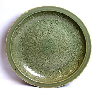
Sold2015Large Rare Yuan/Ming Fine Chinese Carved PlateRare Yuan/Ming Fine Large Chinese Carved Plate with facing Cranes surrounded by Peonies; old inscribed Japanese Collector's Box. Good condition, glaze gaps and a few short cracks all from the originalSee Sold Price
2 days LeftJasper52Chinese Japanese Korean Ports sea chart. lighthouses mail routes. LARGE 1927 map$40
125 Lots AwayMynt AuctionsJapanese Sterling Silver .950 Demitasse Spoons with Engraved Scenes Set of 6$10
May 29Cedarburg Auction & Appraisals LLCSet of Four Maps Showing All of Spain and Portugal$375(2 bids)
Jun 01Link Auction GalleriesA Magnificent Antique Folding 8-Panel Panoramic Japanese Screen (Byobu) Featuring Scenes from Daily$1,500
2 days LeftDreweatts Donnington PrioryA large pair of Samson or Continental Imari vases and covers£500
17 hrs LeftWilliam Bunch Auctions & Appraisals(4) Signed Etchings, Julius Komjati (9) Etchings, and (6) Framed Asian Pictures$50(1 bid)
Jun 07Freeman's | Hindman[MORMONS]. MILLROY & HAYES (fl. 1899). Route of the Mormon Pioneers from Nauvoo to Great Salt Lake,$300


![Central America Caribbean Gulf of Mexico chart Ports lighthouses LARGE 1927 map: TITLE/CONTENT OF MAP: Central American and West Indian Ports [inset The Lesser Antilles; The Windward Passage; Bermudas; Kingston; Havana; Salina Cruz; Puerto Mexico; Mouths of the Mississippi] DATE P](https://p1.liveauctioneers.com/5584/316569/169897699_1_x.jpg?height=310&quality=70&version=1706046386)


![[MORMONS]. MILLROY & HAYES (fl. 1899). Route of the Mormon Pioneers from Nauvoo to Great Salt Lake, (1 of 2)](https://p1.liveauctioneers.com/197/329395/177650560_1_x.jpg?height=282&quality=70&version=1715364962)