Sold2024Civil War era map of N. America with unsettled state bordersOne of the key maps in the 1860s Johnson series of North America. In this map Idaho Territory encompasses what would eventually become Idaho, Montana and Wyoming. Dakota Territory has yet to split intSee Sold Price
Sold2023Civil War era map of N. America with unsettled state bordersOne of the key maps in the 1860s Johnson series of North America. In this map Dakota Territory has yet to split into its north and south divisions while it stretches to encompass what will eventuallySee Sold Price
Sold2022Civil War era map of N. America with unsettled state bordersOne of the key maps in the 1860s Johnson series of North America. In this map Idaho Territory encompasses what would eventually become Idaho, Montana and Wyoming. Dakota Territory has yet to split intSee Sold Price
Sold2022Significant United States map, 1864 Johnson & WardVery interesting hand-colored map created at a pivotal time in the settlement of the American West. In this lovely Civil War era map many of the western states have still not settled their borders. ArSee Sold Price
Sold2021U. S. & N. America w/odd Dakota--Ettling c1860This uncommon Civil War era engraved map shows a very unusual configuration for Dakota. In this map the borders of Wyoming and Utah have yet to be finalized. Numerous Indian tribes are located throughSee Sold Price
Sold2021Civil War era map of deep southern states, 1860/62Title: Civil War era map of deep southern states, 1860/62 Description: "Authentic vintage map of three deep south states whose partial borders are defined by the mighty Mississippi River, one of the gSee Sold Price
Sold2021Civil War-era map of Washington, DC by MitchellNice map of the nation’s capital as it looked during the second year of the Civil War. Notice the vulnerability of the “President’s House.” Also of note are the U. S. Arsenal, U. S. Navy YardSee Sold Price
Sold2022SAMUEL AUGUSTUS MITCHELL JR., AN AMERICAN CIVIL WAR ERASAMUEL AUGUSTUS MITCHELL JR., AN AMERICAN CIVIL WAR ERA MAP, "County Map of Texas," CIRCA 1863, hand-colored lithograph on paper with profusely floral and fruit border, plate 34. from Mitchell's New GSee Sold Price
Sold20211864 U.S. Coast Survey Map of Washington D.C.,Approx. 23" X 40". Upper portion slight staining and minor loss as shown. Highly detailed Civil War era sea chart of part of the Potomac River, including Alexandria and Washington D.C. north to GeorgeSee Sold Price
Sold20221863 Phelps and Watson US Map with Civil War Battles -- Phelps & Watson's Historical and MilitaryTitle: 1863 Phelps and Watson US Map with Civil War Battles -- Phelps & Watson's Historical and Military Map of the Border & Southern States Cartographer: Phelps and Watson Year/Place: 1863, New YorkSee Sold Price
Sold20221864 Civil War MAP United States Statistics Commerce1864 Civil War MAP United States Statistics Commerce American Trade Gold Silver The United States Department of Treasury published this Civil War-era report analyzing the commerce of the US GovernmentSee Sold Price
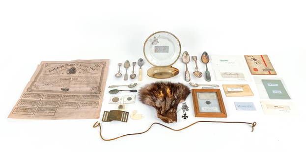
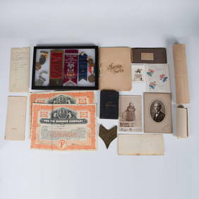
Sold2021U.S. HISTORY CURIOSITIES COLLECTIONCollection of Civil War era artifacts. Some later 19th and 20th C. items, Silver, signatures, etc. With some Western memorabilia. All with labels, none verified or authenticated. Dimensions: (Plate) DSee Sold Price
Sold2022COLLECTION OF WESTERN EXPLORATION MAPS 1850-1860'SA fine collection of original western maps published by the U.S. goverment. Many under the direction of Jefferson Davis. Many of the maps are the large size with the utmost of details showing recentlySee Sold Price
Sold2021Fascinating 1852 map of U. S. w/western territoriesImportant transitional map of the United States showing terrific western territorial borders including the important territorial acquisitions of the Mexican-American War, pre-Gadsden Purchase. Inset mSee Sold Price
Sold20221852 Map of U. S. w/transitional western regionsSignificant double-page map showing transitional western borders including the important territorial acquisitions of the Mexican-American War, pre-Gadsden Purchase. The inset map "No. 6 Map of the GolSee Sold Price
Sold20181852 Map of U. S. w/transitional western regionsReserve Reduced! Significant double-page map showing transitional western borders including the important territorial acquisitions of the Mexican-American War, pre-Gadsden Purchase. The inset map "No.See Sold Price
Sold2023Johnson’s fascinating 1867 North America mapJohnson’s great map of North America showing several western U. S. states with unsettled borders. Wyoming is in a strange configuration and won’t change until its borders are settled witSee Sold Price
Sold2022Scarce Johnson map of the Great Western states, 1864Antique map of California, Nevada, Utah, Colorado, New Mexico, and Arizona. Published during a great time of expansion and change in the U.S. West, as well as during the Civil War. Here Utah displaysSee Sold Price
Sold2016Geroge Cram: Map of Western Part of Quebec, 1891Map: Western Part of Quebec Maker: George Cram Date: 1891 Size: 13.5 x 21.75 inches For "The Home Knowledge Atlas" George F. Cram (1842-1928) served in the U.S. Army during the American Civil War. AftSee Sold Price
Sold2019NORTH AMERICA showing Texas Republic & Western USA asTITLE/CONTENT OF MAP: 'North America' The map shows the borders between the US and Mexico before the Mexican-American war, with much of the present-day western United States as part of Mexico. The RepSee Sold Price
Sold2020Civil War Era U.S. Staff Officer's Sword & Scabbard.Civil War era U.S. Staff Officer's sword and scabbard. Blade marked W. Clauberg Solingen, Schuyler, Hartley & Graham N.Y. Eagle and floral etching with shield on one side and "U.S." on the other. OpenSee Sold Price
Sold201936 star Civil War era U.S. flag, 1865-186736 star Civil War era U.S. flag, 1865-1867, 36 star United States flag, c. 1865-1867, approx. 72"h x 117"w, cord sewn into hoist edge, no grommets Provenance: Property from the Collection of Charles ESee Sold Price
Sold2023Model 1860 Mansfield & Lamb Sword. This Civil War era U.S sword is dated 1865 and inspected byModel 1860 Mansfield & Lamb Sword. This Civil War era U.S sword is dated 1865 and inspected by "C.E.W." (Charles E Wilson) also stamped "Mansfield & Lamb Forerstdale RI" within an oval at the ricasso.See Sold Price
Sold2017Civil War Era Map of Charleston, SC and EnvironsE & G. W. Blunt's Map of Charleston and Vicinity (New York: E & G. W. Blunt, 1862), a handy map for military purposes showing both land and sea routes in the region. Unframed in a 1950s mailing/storagSee Sold Price
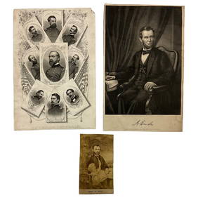
6 days LeftLakeshore Event CenterEphemera, Civil War Generals, Abraham Lincoln, Ulysses Grant, Lot of 3$62(2 bids)
Jul 07Case Antiques, Inc. Auctions & Appraisals3 Civil War Era Photos, incl. Rose O'Neal Greenhow, poss. Jeff Davis$150
Jun 23Schilb Antiquarian Rare Books1918 Robert E Lee Civil WAR Confederate General CSA Battles MAPS Illustrated$48(5 bids)
Jun 23Schilb Antiquarian Rare Books1890 1ed Confederate Memoirs of Joseph Johnston & Jefferson Davis Civil War CSA$66(3 bids)
Jun 26University ArchivesCapture of Jefferson Davis: “Mr. Davis tried to escape…with a ladies waterproof$1,600
Jul 14Schilb Antiquarian Rare Books1928 Life of Abraham Lincoln 1ed SLAVERY Civil War Albert Beveridge 2v SET$1
Jul 04Weatherham Estate TreasuresAbraham Lincoln Bronze Bust Sculpture On Marble Base - Signed Original - 10lbs$400
Jun 26University ArchivesIconic U.S. Grant Battlefield Albumen by Mathew Brady at City Point During Siege of Petersburg$400
Jul 14Schilb Antiquarian Rare Books1885 Civil War 1ed Memoirs of Union General Ulysses S. Grant Illustrated MAPS 2v$76(5 bids)
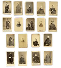
Jun 26University Archives18 pc. CDV Archive of Civil War Generals Incl. Many Brady & E. Anthony Examples$260(1 bid)
Jul 06Case Antiques, Inc. Auctions & AppraisalsCivil War Veteran GAR Uniform, PVT Stephen F. Oliver$200(1 bid)
Jun 23Schilb Antiquarian Rare Books1860 Political Textbook 1ed SLAVERY Abe Lincoln Douglass Civil War Government$74(4 bids)
Jun 28South Florida Auction & Estate Sale Services IncABRAHAM LINCOLN Memorial Belt Buckle Approved by MRS. LINCOLN$22(2 bids)
Jun 28South Florida Auction & Estate Sale Services IncCivil War Abraham Lincoln Tin Type Photograph$8(2 bids)