Sold2017Cluver: Antique Map of Siberia from Caspian Sea, 1700Map: 1700 Cluver Map of Siberia from the Caspian Sea -- Scythia et Serica Cartographer: P Cluver Year / Place: 1700 Dimensions: 8 X 12 in. Condition: Excellent. Sharp hand colors on a nice strike. OnlSee Sold Price
Sold2017Bowen: Antique Map of Caspian Sea Reserve, 1747Map: Caspian Sea Reserve Date Printed: 1747 Cartographer: E. Bowen Material/Medium: Paper Size: 10 1/4" x 14" Condition: Excellent Handcolored, copperplate engraved. Printed in London. From "A CompletSee Sold Price
Sold2018Antique Framed Map of The Caspian Sea Area of Asia26.5x23.5 inches, Nova & Accvrata Wolgae Flvminis olim RHA dicti Delineatio Auctore Adamo Oleario.See Sold Price
Sold2019Pictorial antique maps TartaryThis is a highly decorative 1851 map of Independent Tartary by John Tallis and John Rapkin. It covers the regions between the Caspian Sea and Lake Bakquash and between Russia and Afghanistan. These inSee Sold Price
Sold2017Martier: Antique Map of Ancient Caucasus Region, 1705Map: Ancient Caucasus region Armenia, Georgia & between Black Sea & Caspian Sea Date Printed: 1705-06 Cartographer: Pierre Martier Material/Medium: Paper Size: 24 1/2" x 16 1/2" Condition: Excellent OSee Sold Price
Sold2016Bowen map of Caspian Sea 1747Heading: (Map) Author: Bowen, Emanuel Title: A New and Accurate Map of the Caspian Sea Laid down from the Memoirs of Soskam Sabbas a Georgian Prince Place Published: London Publisher: Date PublisSee Sold Price
Sold2017Malte-Brun: Antique Map of Siberia, 1846Title/Content of Map: 'Sibérie ou Russie d'Asie'. Siberia. Russia in Asia Date Printed: c1846 Image Size: Approx 23.0 x 30.5cm, 9 x 12 inches (Large) Type: Antique engraved map with original outlineSee Sold Price
Sold2017Bradford: Antique Map of Siberia & Central Asia, 1835Map: Siberia & Central Asia Date Printed: 1835 Cartographer: T.G. Bradford Material/Medium: Paper Size: 13" x 9 1/2" Condition: Very Good. Some foxing on edges. Does not affect Map. Hand colored outliSee Sold Price
Sold2018The Caspian Sea Drawn by the Czar's Special Command byTitle/Content of Map: The Caspian Sea Drawn by the Czar's Special Command by Carl van Verden in the Year 1719. 1720 and 1721 Date: 1721, London Cartographer: H Moll Size: 10.5 x 8.3 in. This map of thSee Sold Price
Sold2024Puerto Rico Antique Maps (3)Group of 3 antique folding map sea charts. One of Puerto Rico. Another of San Juan Harbor. The third a composite including Mayaguez Bay. Washington, D.C.: 1899. All fold as issued.See Sold Price
Sold2024Antique Map of Poland, 1700 by Guillaume De Lisle, ParisAntique Map of Poland, 1700 by Guillaume De Lisle, Paris. 26 3/4 x 32 3/4 in framed. 19 x 25 in unframed.Local Pick up call one day before to make an appointment. TO SHIP THIS ITEM IN USA OR INTERNATISee Sold Price
Sold2022Pieter Goos (1616-1675) - Antique Map of Celtic Sea - Antique Sea ChartPieter Goos (1616–1675). Accurate nautical chart of the Celtic Sea oriented north to the left. The title cartouche depicts Nereus and his children, the Nereids, with cross staffs and an astrolaSee Sold Price
Sold2020Early map of the Caspian Sea by De l'IsleHeading: Author: De l'Isle, Guillaume Title: Carte Marine de la Mer Caspiene [with] Cost de la Perse Sur la Mer Caspiene et Partie de Celles de Tartarie Place Published: Paris Publisher:Chez Sr. DeliSee Sold Price
Sold20191784 Cadell Map of the Caspian Sea Region -- Chart ofTitle/Content of Map: 1784 Cadell Map of the Caspian Sea Region -- Chart of the Caspian Sea Date: 1784, London Cartographer: T CadellSize: 7.5 x 6.3 in. A very nice map of the then recently explored cSee Sold Price
Sold2024Antique Map of Black Sea - John Rapkin - Europe - Asia - Turkey, Romania, Bulgaria, Ukraine"Black Sea". Fine map of the Black Sea, with an elaborate decorative border. The map shows eastern Europe and central Asia, including Turkey, Romania, Bulgaria, Ukraine, Russia, and Georgia.See Sold Price
Sold2017Bellin: Antique Map of Eastern Siberia, 1750Map: Eastern Siberia Date Printed: 1750-60's Cartographer: Jacques Nicolas Bellin Material/Medium: Paper Size: 14" x 11" Condition: Excellent Copperplate engraving. Double page Map. From the Atlas DeSee Sold Price
Sold2019Barclay, James 1809 Antique Map. Turkey & Black Sea"Turkey in Europe with Asia Minor" Outline Hand Coloured Copper Engraved Map Published 1809, Leeds for "Barclay's Complete and Universal Dictionary of the English Language..." by the Rev. James BarclaSee Sold Price
Sold2018Bellin: Antique Map of Eastern Siberia, 1740Title/Content of Map: Easter Siberia off Sakhalin Island Date Printed: 1740-70's Cartographer: J.N. Bellin & J.F. La Harpe Material/Medium: Paper Size: 15" x 9 3/4" Copperplate engraved. From the 'AbrSee Sold Price
Sold2018Zurner: Antique Map of the World, 1700Title/Content of Map: World Map by Zurner Date Printed: c1700 Cartographer: A.F. Zurner Material/Medium: Paper Size: 20" x 21" Rare world Map. Hand colored engraved. Please note that this lot has a coSee Sold Price
2017Antique Map of Biblical Land, 1700Map: Carte Des pais bibliques Size: 19 x 14 Date: 1700s Please note that this lot has a confidential reserve. When you leave a bid in advance of the auction, submit your maximum. Jasper52 will bid onSee Sold Price
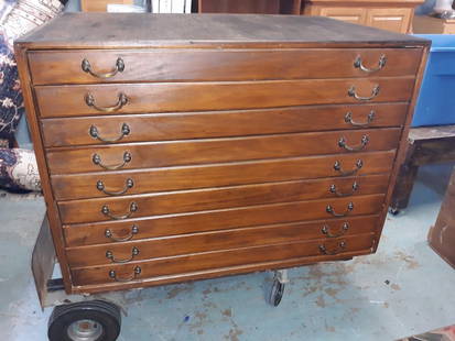
Sold2020Antique Map Architect Blue Print Sea Captain Chest 9 drAntique Map Architect Blue Print Sea Captain Chest 9 drawers custom made flat file cabinet for sea captain architect or blue prints,Maps, 9 drawers all on roller glides drawers work great very good coSee Sold Price
Sold2017Thomson: Antique Chart Map of Mediterranean Sea, 1817Chart of the Mediterranean Sea. Bay & roads of Marseilles. The harbour of Genoa. Plan of the Rock and Bay of Gibraltar, shewing the position of the combined fleet and attack of the battering ships inSee Sold Price
Sold2020Antique Map Architect Blue Print Sea Captain Chest 9 drcustom made flat file cabinet for sea captain architect or blue prints,Maps, 9 drawers all on roller glides drawers work great very good condition see all pics 34 1/2" tall x 41 1/2" wide x 28" deeploSee Sold Price
Sold2020Caspian Sea. Detailed map. Best to dateTitle: Caspian Sea. Detailed map. Best to date Description: By. Herman Moll. From. Atlas minor. Published. London. Date/ Period: 1729-1736 Materials: Copperplate engraved. Dimensions: 13 1/2 x 9 “ RSee Sold Price
5 days LeftJasper521764 Bowen Map of West India to Iran -- India As Described By All Authors Before The Fifth Century$80
6 days LeftJasper52West India Islands & Caribbean Sea Sheet 2 ADMIRALTY sea chart 1913 (1949) map$120
6 days LeftJasper52Jamaica & the Pedro Bank. South Cuba Haiti. ADMIRALTY sea chart 1866 (1968) map$120
Featured6 days LeftJasper52Jamaica SE coast Morant-Portland Pt Kingston ADMIRALTY sea chart 1963 (1971) map$120
Featured6 days LeftJasper52Barbuda Island. West Indies Caribbean. ADMIRALTY sea chart 1850 (1966) old map$120
6 days LeftJasper52Grand Bahama & Great Abaco Islands. Bahamas. ADMIRALTY sea chart 1886 (1968) map$140
Featured6 days LeftJasper52Havana Harbour, Cuba. Caribbean. ADMIRALTY sea chart 1954 (1955) old map$140
6 days LeftJasper52Antigua Falmouth English Harbour West Indies ADMIRALTY sea chart 1954 (1968) map$280
Featured6 days LeftJasper52Anguilla St. Martin/Maarten Barts. Caribbean. US Navy sea chart 1899 (1917) map$280
6 days LeftHunt and Peck Estate Services, Inc.1696 Jaillot Mapping The Ottoman Empire at the End of the 17th Century$140
6 days LeftJasper52Amér Sep Grandes Antilles 73 Jamaica Pedro Bank San Andrés VANDERMAELEN 1827 map$45
6 days LeftJasper52Amér. Sep. Curacao #74. Aruba Bonaire Puerto Rico Beata. VANDERMAELEN 1827 map$130


![Early map of the Caspian Sea by De l'Isle: Heading: Author: De l'Isle, Guillaume Title: Carte Marine de la Mer Caspiene [with] Cost de la Perse Sur la Mer Caspiene et Partie de Celles de Tartarie Place Published: Paris Publisher:Chez Sr. Deli](https://p1.liveauctioneers.com/642/162817/82203053_1_x.jpg?height=310&quality=70&version=1582924314)