Sold2017De Fer: Map of Barcelonne, Barcelona, 1705Map: 'Barcelonne [Barcelona] Fortifed town/city plan' Date Printed: 1705 Image Size: Approx 19.0 x 31.5cm, 7.5 x 12.25 inches (Medium) Type: Early 18th century copperplate map Condition: Fair: A tearSee Sold Price
Sold2018de Fer: Oudenarde'. Oudenaarde . Fortifed town/cityTITLE/CONTENT OF MAP: 'Oudenarde [Oudenaarde ]' DATE PRINTED: 1705 IMAGE SIZE: Approx 23.5 x 34.5cm, 9.25 x 13.75 inches (Large) TYPE: Early 18th century copperplate map CONDITION: Good; suitable forSee Sold Price
Sold2018de Fer: Verceil'. Vercelli. Plan of town/city &TITLE/CONTENT OF MAP: 'Verceil [Vercelli]' DATE PRINTED: 1705 IMAGE SIZE: Approx 18.5 x 26.5cm, 7.25 x 10.5 inches (Medium) TYPE: Early 18th century copperplate map CONDITION: Good; suitable for framiSee Sold Price
Sold2018de Fer: Antique Map of Pinerolo, Italy, 1705Title/Content of Map: 'Pignerol [Pinerolo]' Plan of town/city & fortifications. Italy. Date Printed: 1705 Image Size: Approx 21.5 x 31.5cm, 8.5 x 12.25 inches (Large) Type: Early 18th century copperplSee Sold Price
Sold2020Group of Assorted Antique Maps of Vienna AustriaGroup of Assorted Antique Maps of Vienna, Austria including 'Plan de la Ville et des Fauxbourgs de Vienne,''Derivation du Danube pres de Vienne,' 'Erz~Herzogthum Oesterreich:Unter Der Enns 1853,' 'DieSee Sold Price
Sold2015Plan of the Battle of Vienna September 12, 1683. PolandPlan of the Battle of Vienna September 12, 1683. Poland. 1839.Print of steel engraving titled „Plan de la Bataille de Vienne livrie le 12 Septembre 1683“.Author unknown.Engraved by Bigant.From PORSee Sold Price
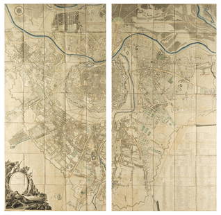
Sold2018Austria.- Grimm (Maximilian von) Grundriss der Kl: Kl:Austria.- Grimm (Maximilian von) Grundriss der Kl: Kl: Haupt und Residenzstadt Wien mit ihren Vorstadten nach den Neuen Hausnumern 1797 / Plan de la Ville de Vienne et de ses Fouxbourgs avec le DenombSee Sold Price
Sold2018de Fer: Plan de Tripoli in Barbarie' fortifiedTITLE/CONTENT OF MAP: '[Plan de Tripoli in Barbarie] [Tripoli, Libya]' DATE PRINTED: 1705 IMAGE SIZE: Approx 24.5 x 36.5cm, 9.75 x 14.25 inches (Large) TYPE: Early 18th century copperplate map CONDITISee Sold Price
Sold2022View of Vienna ''Vue de Vienne priView of Vienna ''Vue de Vienne prise du cote de chateau de Schönbrunn'', c. 1830, outline etching, old coloured, drawn by Högl, engraved by Schwartz, published by M. Guérin, Paris, inscribedSee Sold Price
Sold2019Plan de la Ville de Meaco'. Kyoto town city plan,TITLE/CONTENT OF MAP: 'Plan de la Ville de Meaco A.Quartier de Dayri ou Empereur hereditaire B. Palais du Cubosama [Plan of the city of Kyoto]' DATE PRINTED: 1752 IMAGE SIZE: Approx 20.5 x 29.0cm, 8 xSee Sold Price
Sold20201705 deFer Map of London -- Plan des Villes de LondresTitle/Content of Map: 1705 deFer Map of London -- Plan des Villes de Londres et de Westminster et de leurs Faubourgs avec le Bourg de Southwark Date: 1705, Paris Cartographer: N deFerSize: 8.7 X 13.1See Sold Price
Sold20221582 Braun and Hogenberg Views of Lyon and Vienna, France -- Lugdunum vulgo Lion [on sheet with]Title: 1582 Braun and Hogenberg Views of Lyon and Vienna, France -- Lugdunum vulgo Lion [on sheet with] Vienna vulgo Vienne de France Cartographer: Braun and Hogenberg Year / Place: 1582 c., Koln MapSee Sold Price
Sold20201705 Engraved Plan Fortified Island De Fer1705 plan by Nicolas de Fer “Mons, Comme il est Aujourdhuy”, printed at Paris. Fine engraving of the capital of the province of Hanaut. Measures 16 x 11”. Reserve: $20.00 Shipping: Domestic: FlaSee Sold Price
Sold2021Town city 'Plan de la Ville de Louvo'. Lopburi,TITLE/CONTENT OF MAP: 'Plan de la Ville de Louvo [Plan of the city of Lopburi]' The top image on the right hand side shows the entire map. To view a close up of the map showing the level of printed deSee Sold Price
Sold2021Plan de Jedo'. Tokyo antique town city plan. Japan.TITLE/CONTENT OF MAP: 'Plan de Jedo, A.Palais de l'Empereur B.Niponbas ou le pont de l'Empereur [Plan of Tokyo]' The top image on the right hand side shows the entire map. To view a close up of the maSee Sold Price
Sold2022Nicolas de La Mare (French, 1639–1723), Antoine Coquart (French, 1668–1707), and Nicolas de FerNicolas de La Mare (French, 1639–1723), Antoine Coquart (French, 1668–1707), and Nicolas de Fer (French, 1646-1720), "Cinquieme Plan de la Ville de Paris," c. 1705, hand-colored map, preSee Sold Price
Sold2020[MILITARY ARCHITECTURE] 9 plans together[Fortifications and Military Architecture.] A collection of nine maps sold together including Fer, Nicolas de. PLAN DE LA VILLE OUVRAGES ET CHTEAU DE NAMUR. Paris, [c. 1692] 36 x 51.5 cm. **And eightSee Sold Price
Sold2017Nicolas De Fer: Carte Generale du Globe Terrestre, 1705Map: Carte Generale du Globe Terrestre et Aquatiques ou Mappemonde en Deux Plans-Hemisphere [Scarce 1705 antique map with California as an island] Maker: Nicolas De Fer Size: 8.125 x 11.125 (10.25 x 1See Sold Price
Sold2019Plan de la ville et du port de Macao'. Macau town cityTITLE/CONTENT OF MAP: 'Plan de la Ville et du port de Macao [Plan of the City and Port of Macau]' The top image on the right hand side shows the entire map. To view a close up of the map showing the lSee Sold Price
Sold2018Royal Vienna Austria Porcelain Horse FigurineWien Austria Blanc de Chine Porcelain Horse Figurine. Circa 1900s. Marked on the bottom. =; Size: 10.5"H x 9.5"L x 3.5"WSee Sold Price
Sold2024De Fer Map of the Mississippi RiverDE FER, Nicolas (1646-1720). Partie Meridionale de la Riviere de Missipi, et ses environs, dans l'Amerique Septentrionale. Mis au jour par N. de Fer. Geographe de sa Majeste Catolique 1718. Engraved mSee Sold Price
Sold2020DANET, GUILLAUME; after DE FER, NICOLAS. Mappe-Monde ouDANET, GUILLAUME; after DE FER, NICOLAS. Mappe-Monde ou Carte Generale de la Terre. Engraved decorative double-hemispheric wall map of the world on two sheets joined with additional title-banner and bSee Sold Price
Sold2022Jean Pougny (French, 1894-1956) Paysage de Paris (La Ligne de Chemin de Fer)Jean Pougny (French, 1894-1956) Paysage de Paris (La Ligne de Chemin de Fer) signed in Latin (lower right) oil on canvas 10.5 x 21.5cm (4 1/8 x 8 7/16in). Footnotes: Russian-French artist IvSee Sold Price
Sold2020Louis Vivin (French, 1861-1936) Chemins de fer d'Etat,Louis Vivin (French, 1861-1936) Chemins de fer d'Etat, Paris - Gare des Invalides oil on canvas signed L Vivin (lower left) 18 ¼ x 24 inches. Provenance: Sold: Tajan, Paris, November 16, 2000, loSee Sold Price
7 days LeftHermann Historica GmbHA bronze gladiator with pugio and shield, Bruno Zach aka Prof. Tuch (1891 Zhytomyr - 1945 Vienna),€800
May 16BonhamsMARCEL JEAN (1900-1993) L'île de fer 31 11/16 x 39 1/8 in (80.5 x 99.3 cm) (Painted in 1970)$4,800
4 days LeftArt Legacy AuctionsLithograph from 1931 Chemin de Fer de Paris a Orleans et du midi salies de Bearn vintage travel$550
3 mins LeftJasper52Chemins De Fer - Moserboden - Art By J. Politzer (1921) 26.75x37.625 French Travel Poster LB$320
May 18Art Legacy AuctionsLithograph from 1931 Chemin de Fer de Paris a Orleans et du midi salies de Bearn vintage travel$550
May 16Potter & Potter AuctionsPLANSON, Andre (1898 – 1981). Provence / Societe Nationale ...$125
May 21Sworders Fine Art AuctioneersA ladies 18ct gold diamond set mechanical bracelet watch, c.1913,£30
May 16Potter & Potter AuctionsCAVAILLES, Jules (1901 – 1977). Languedoc / Societe Nationa...$80
7 days LeftGolden Gate AuctioneerChristian Dior Canvas Embroidered Medium Plan de Paris Lady D-Lite Black White$1(1 bid)
3 days LeftGolden Gate AuctioneerChristian Dior Calfskin Plan De Paris Printed Saddle Bag With Strap Beige Black$1
759 Lots AwayMynt AuctionsFer De Lance by Puiforcat French Sterling Silver Waffle Server GW BC 10 1/4"$10
May 16Golden Air AuctionsChristian Dior Calfskin Plan De Paris Printed Saddle Bag With Strap White Black$4,350
3 days LeftGolden Gate AuctioneerChristian Dior Canvas Embroidered Medium Plan De Paris Book Tote Black White$1
1 day LeftRapid Estate Liquidators and Auction Gallery8 Vintage Silver Plated Spoons Souvenir & Flatware$55


![De Fer: Map of Barcelonne, Barcelona, 1705: Map: 'Barcelonne [Barcelona] Fortifed town/city plan' Date Printed: 1705 Image Size: Approx 19.0 x 31.5cm, 7.5 x 12.25 inches (Medium) Type: Early 18th century copperplate map Condition: Fair: A tear](https://p1.liveauctioneers.com/5584/102391/52309321_1_x.jpg?height=310&quality=70&version=1491597186)


![de Fer: Oudenarde'. Oudenaarde . Fortifed town/city: TITLE/CONTENT OF MAP: 'Oudenarde [Oudenaarde ]' DATE PRINTED: 1705 IMAGE SIZE: Approx 23.5 x 34.5cm, 9.25 x 13.75 inches (Large) TYPE: Early 18th century copperplate map CONDITION: Good; suitable for](https://p1.liveauctioneers.com/5584/117068/60186836_1_x.jpg?height=310&quality=70&version=1519783227)
![de Fer: Verceil'. Vercelli. Plan of town/city &: TITLE/CONTENT OF MAP: 'Verceil [Vercelli]' DATE PRINTED: 1705 IMAGE SIZE: Approx 18.5 x 26.5cm, 7.25 x 10.5 inches (Medium) TYPE: Early 18th century copperplate map CONDITION: Good; suitable for frami](https://p1.liveauctioneers.com/5584/117068/60186890_1_x.jpg?height=310&quality=70&version=1519783227)
![de Fer: Antique Map of Pinerolo, Italy, 1705: Title/Content of Map: 'Pignerol [Pinerolo]' Plan of town/city & fortifications. Italy. Date Printed: 1705 Image Size: Approx 21.5 x 31.5cm, 8.5 x 12.25 inches (Large) Type: Early 18th century copperpl](https://p1.liveauctioneers.com/5584/115996/59594962_1_x.jpg?height=310&quality=70&version=1517965654)


![de Fer: Plan de Tripoli in Barbarie' fortified: TITLE/CONTENT OF MAP: '[Plan de Tripoli in Barbarie] [Tripoli, Libya]' DATE PRINTED: 1705 IMAGE SIZE: Approx 24.5 x 36.5cm, 9.75 x 14.25 inches (Large) TYPE: Early 18th century copperplate map CONDITI](https://p1.liveauctioneers.com/5584/117068/60186956_1_x.jpg?height=310&quality=70&version=1519783227)

![Plan de la Ville de Meaco'. Kyoto town city plan,: TITLE/CONTENT OF MAP: 'Plan de la Ville de Meaco A.Quartier de Dayri ou Empereur hereditaire B. Palais du Cubosama [Plan of the city of Kyoto]' DATE PRINTED: 1752 IMAGE SIZE: Approx 20.5 x 29.0cm, 8 x](https://p1.liveauctioneers.com/5584/156033/78750029_1_x.jpg?height=310&quality=70&version=1575421548)

![1582 Braun and Hogenberg Views of Lyon and Vienna, France -- Lugdunum vulgo Lion [on sheet with]: Title: 1582 Braun and Hogenberg Views of Lyon and Vienna, France -- Lugdunum vulgo Lion [on sheet with] Vienna vulgo Vienne de France Cartographer: Braun and Hogenberg Year / Place: 1582 c., Koln Map](https://p1.liveauctioneers.com/5584/272286/142770672_1_x.jpg?height=310&quality=70&version=1671577913)

![Town city 'Plan de la Ville de Louvo'. Lopburi,: TITLE/CONTENT OF MAP: 'Plan de la Ville de Louvo [Plan of the city of Lopburi]' The top image on the right hand side shows the entire map. To view a close up of the map showing the level of printed de](https://p1.liveauctioneers.com/5584/200280/101303623_1_x.jpg?height=310&quality=70&version=1618350002)
![Plan de Jedo'. Tokyo antique town city plan. Japan.: TITLE/CONTENT OF MAP: 'Plan de Jedo, A.Palais de l'Empereur B.Niponbas ou le pont de l'Empereur [Plan of Tokyo]' The top image on the right hand side shows the entire map. To view a close up of the ma](https://p1.liveauctioneers.com/5584/192167/96862305_1_x.jpg?height=310&quality=70&version=1611703298)

![[MILITARY ARCHITECTURE] 9 plans together: [Fortifications and Military Architecture.] A collection of nine maps sold together including Fer, Nicolas de. PLAN DE LA VILLE OUVRAGES ET CHTEAU DE NAMUR. Paris, [c. 1692] 36 x 51.5 cm. **And eight](https://p1.liveauctioneers.com/1124/187577/94368877_1_x.jpg?height=310&quality=70&version=1607095126)
![Nicolas De Fer: Carte Generale du Globe Terrestre, 1705: Map: Carte Generale du Globe Terrestre et Aquatiques ou Mappemonde en Deux Plans-Hemisphere [Scarce 1705 antique map with California as an island] Maker: Nicolas De Fer Size: 8.125 x 11.125 (10.25 x 1](https://p1.liveauctioneers.com/5584/106187/54391534_1_x.jpg?height=310&quality=70&version=1499460562)
![Plan de la ville et du port de Macao'. Macau town city: TITLE/CONTENT OF MAP: 'Plan de la Ville et du port de Macao [Plan of the City and Port of Macau]' The top image on the right hand side shows the entire map. To view a close up of the map showing the l](https://p1.liveauctioneers.com/5584/152091/76804722_1_x.jpg?height=310&quality=70&version=1571180311)


