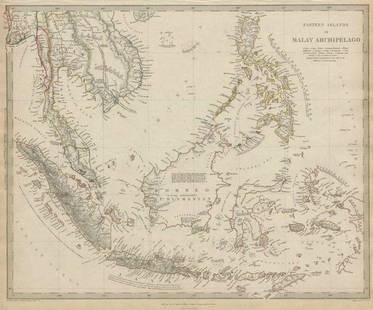
Sold2017Eastern Islands Or Malay Archipelago Map, 1836Eastern Islands Or Malay Archipelago. Baldwin & Cradock/S.D.U.K. 1836-12-01. Drawn from authorities Horsburgh, Raffles, Crawfurd, Duperray, Laplace &c. Printed by Russell, Penge. Please note that thisSee Sold Price
Sold2018Eastern Islands Or Malay ArchipelagoMap: Eastern Islands Or Malay Archipelago Date: 1852 Cartographer: WALKER, J. & C. Publisher: GEORGE COX/S.D.U.K. Size (inches): 12.5X16 Map showing southern Siam, Archipelago Filipino, Celebes, BorneSee Sold Price
Sold2020MALAY ARCHIPELAGO Indonesia Malaysia PhilippinesTITLE/CONTENT OF MAP: 'EASTERN ISLANDS OR THE MALAY ARCHIPELAGO. Sumatra, Java, Borneo, etc' The top image on the right hand side shows the entire map. To view a close up of the map showing the levelSee Sold Price
Sold2020MALAY ARCHIPELAGO Indonesia Malaysia PhilippinesTITLE/CONTENT OF MAP: 'EASTERN ISLANDS OR THE MALAY ARCHIPELAGO. Sumatra, Java, Borneo, etc' The top image on the right hand side shows the entire map. To view a close up of the map showing the levelSee Sold Price
Sold2022Earl, The Eastern Seas w/ four mapsHeading: Author: Earl, George Windsor Title: The Eastern Seas, or Voyages and Adventures in the Indian Archipelago in 1832-33-34, Comprising a Tour of the Island of Java- Visits to Borneo, the MalaySee Sold Price
Sold2021MALAY ARCHIPELAGO/EAST INDIA ISLANDS PhilippinesTITLE/CONTENT OF MAP: 'Malay Archipelago or East India Islands' Vignettes: Victoria Mount - New Guinea; Near Sarawak - Borneo; Natives of New Guinea; The Bee Bear. The map covers the area from Burma aSee Sold Price
Sold2019Butler, George 1874 Pair of Maps. Asia & East Indies"Asia" and "The Malay Archipelago" Lithograph Maps Published 1874, London for "The Public School Atlas of Modern Geography" by Rev. George Butler. Paper Size: Up to 13.75 x 10.5 inch (35 x 27cm) GoodSee Sold Price
Sold2019Bartholomew, John 1922 Pair Large Maps of East Indies"Farther India" showing Siam, Indonesia, Singapore, Malaysia. Together with "Malay Archipelago" Large Lithograph Map Published 1922 by The Times, London for "The Times Survey Atlas of the World" MapsSee Sold Price
Sold2019Malaya 1911-1922 Pair of Maps of the East IndiesBoth titled "Malay Archipelago" Large Lithograph Maps Published 1922 by The Times, London for "The Times Survey Atlas of the World" Maps by John George Bartholomew of the Edinburgh Geographical InstitSee Sold Price
Sold2020Bartholomew, John 1922 Pair of Maps. East Indies"Farther India" and "Malay Archipelago" Large Lithograph Maps Published 1922 by The Times, London for "The Times Survey Atlas of the World" Maps by John George Bartholomew of the Edinburgh GeographicaSee Sold Price
Sold2023New Zealand Sandwich Galapagos Islands. Papuan Archipelago. Melanesia 1859 mapNew Zealand. // Sandwich Islands, or Hawaiian Group, // Galapagos Islands // Papuan Archipelago' by John Bartholomew (1859). Antique engraved atlas map with original hand colour/color, 37.0 x 53.5cm,See Sold Price
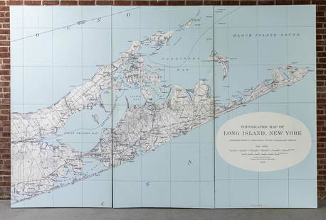
Sold2022Three Panel Water Current Map of Eastern Long Island on Canvas with FrameOver scaled Eastern Long Island water current map on three panel canvas, strengthened on frame. Please note of wear consistent with age. Each panel measures 48"W x 2"D x 96"H.See Sold Price
Sold2017William Faden 1796 Map Eastern US, North AmericaFaden, William (BRITISH, 1749-1836); Map of the Eastern United States, North American with British Territories and Those of Spain according to the Treaty of 1784 (from a larger atlas), 1796; handcolorSee Sold Price
Sold2020Encyclo. Britannica C1830 Map of East Indies & Burma"Eastern Islands, Birmah &c" Steel Engraved Map Published 1830-42, Edinburgh for "Encyclopedia Britannica" Seventh Edition. Centre fold as issued. Paper Size: 16 x 11 inch (40 x 28cm) Good conditionSee Sold Price
Sold2018Bellin: Antique Map of Maluku Islands, 1740Title/Content of Map: Maluku Islands of Eastern Indonesia Date Printed: 1740-70's Cartographer: J.N. Bellin & J.F. La Harpe Material/Medium: Paper Size: 6" x 9 3/4" Copperplate engraved. Published inSee Sold Price
Sold2024Siam and the Malay Archipelago. Indonesia Indochina Philippines. TIMES 1895 mapTITLE/CONTENT OF MAP: 'Siam and the Malay Archipelago' DATE PRINTED: 1895 IMAGE SIZE: Approx 38.5 x 25.5cm, 15.25 x 10 inches (Large) TYPE: Antique colour atlas map CONDITION: Good; suitable for framiSee Sold Price
Sold2022Kelly, Christopher 1836 Antique Map. East India IslandsCopper Engraved Map Published 1836, London for "A New and Complete System of Universal Geography" by Christopher Kelly. Maps Engraved by Findlay, Wallis and others. Paper Size: 10.5 x 8 inch (27 x 20cSee Sold Price
Sold2022Universal Atlas 1893 LG Map. Siam and the Malay ArchipelagoLithograph Map Published 1893 by Cassell & Co., London for "The Universal Atlas" Centre fold as issued. Paper Size: 16 x 10.5 inch (41 x 27cm) Good ConditionSee Sold Price
Sold2021Tallis, John (Pub) 1852 Malay Archipelago. East IndiesSteel Engraved Map with Original Outline Hand Color Published 1852-56 by John Tallis, London for "The Universal Pronouncing Dictionary" by Thomas Wright. Drawn & Engraved by John Rapkin. Centre fold aSee Sold Price
Sold2020Wallace (Alfred Russel) The Malay Archipelago, fifthNO RESERVE Wallace (Alfred Russel) The Malay Archipelago, fifth edition, half-title, wood-engraved frontispiece, 7 plates and numerous illustrations, 2 folding colour maps, advertisement leaf at end,See Sold Price
Sold2019Three Maps from the Hydrographic Office U. S. Navy,Three Maps from the Hydrographic Office U. S. Navy, consisting of "England & France, Southern Approaches to Dover Strait,"1915, H. - 45 3/4 in., W. -34 in.; with "Eastern Archipelago, Straits BetweenSee Sold Price
Sold2019Three Maps from the Hydrographic Office U. S. Navy, theThree Maps from the Hydrographic Office U. S. Navy, the first "Eastern Archipelago, Lombok to Flores including Paternoster and Postillion Is.," 1924, H. - 27 1/8 in., W. - 39 5/8 in.; with "North PaciSee Sold Price
Sold2020Nautical Map / Sea Chart, #1212 Eastern Long IslandDescription: Nautical Map / Sea Chart, United States East Coast, Connecticut - New York, Long Island Sound, Eastern Part, 12th edition feb 10 / 69 ; all measurements are approximate; Folded; ShippingSee Sold Price
Sold2019The Times 1895 Pair of Maps. East Indies, Asia"Siam and the Malay Archipelago" and "Burma and the Malay Peninsula" Lithograph Maps Published 1895, London for "The Times Atlas" Paper Size: 16 x 10.5 inch (41 x 27cm) Good ConditionSee Sold Price
2 days LeftJasper52Océanique. Partie des Iles Salomon #33. Solomon Islands. VANDERMAELEN 1827 map$65
2 days LeftJasper52Océanique. Partie des Iles Salomon #33. Solomon Islands. VANDERMAELEN 1827 map$65
Featured2 days LeftJasper52New Zealand Sandwich Galapagos Islands. Papuan Archipelago. Melanesia 1860 map$130(1 bid)
2 days LeftJasper52Océanique. Partie des Iles Salomon #32. Solomon Islands. VANDERMAELEN 1827 map$75
2 days LeftJasper52Océanique. Partie des Iles Salomon #32. Solomon Islands. VANDERMAELEN 1827 map$75
2 days LeftJasper52New Guinea & Papuan Archipelago. Solomon & Bismarck islands. THE TIMES 1900 map$20
2 days LeftJasper52New Guinea & Papuan Archipelago. Solomon & Bismarck islands. THE TIMES 1895 map$25
2 days LeftJasper52Océanique. Partie des Iles Carolines #9. Yap Micronesia. VANDERMAELEN 1827 map$50
2 days LeftJasper52Océanique. Partie des Iles Carolines #9. Yap Micronesia. VANDERMAELEN 1827 map$50
2 days LeftJasper52Océanique. Partie… des Iles Basses #49 Gambiers Polynesia. VANDERMAELEN 1827 map$60
2 days LeftJasper52Océanique. Partie… des Iles Basses #49 Gambiers Polynesia. VANDERMAELEN 1827 map$60
2 days LeftJasper52Océanique. Iles des Amis #47. Tonga. Lau & Moala, Fiji. VANDERMAELEN 1827 map$85
2 days LeftJasper52Océanique. Iles des Amis #47. Tonga. Lau & Moala, Fiji. VANDERMAELEN 1827 map$85
2 days LeftJasper52Océanique Partie… des Iles Basses 48 SE Tuamotus Polynesia VANDERMAELEN 1827 map$50
2 days LeftJasper52Océanique Partie… des Iles Basses 48 SE Tuamotus Polynesia VANDERMAELEN 1827 map$50
2 days LeftJasper52Océanique Iles de la Société #42 Tahiti Rangiroa Polynesia VANDERMAELEN 1827 map$85
2 days LeftJasper52Océanique. Nouvelle Caledonie #46. New Caledonia Vanuatu. VANDERMAELEN 1827 map$85
2 days LeftJasper52Océanique. Nouvelle Caledonie #46. New Caledonia Vanuatu. VANDERMAELEN 1827 map$85