Sold2021Eight Antique Maps by HoefnagelEight Antique Maps by Hoefnagel , 17th c., from Civitates Orbis Terrarum, 5 hand-colored, sheets 16 in. x 20 in Provenance: Property deaccessioned from the Louisiana State Museum, proceeds to be usedSee Sold Price
Sold2023Eight Antique Maps of TexasEight Antique Maps of Texas , incl. "Map of the United States and Texas Boundary Line...", 1857-1860 (1902); "Map of a Tour from Independence...by A. Wislizenus, in 1846 and 1847"; "N.W. Corner & Pan-See Sold Price
Sold2023Eight Antique Maps, Mostly EuropeDescription: A group of antique maps including an 18th century map of Spain and Portugal by Thomas Jefferys, a ca. 1800 map of Italy from the Guthrie atlas, an early 19th century Henry Schenck TannerSee Sold Price
Sold2019Ca.1853 Antique Maps by A. and C. Black (8)Circa 1853 eight antique maps Published by A. and C. Black, Edinburgh. Measure 17.375 in. x 12.375 and 12.375 x 17.375. Unframed, loose and not mounted or glued down. If lot is absent of a condition rSee Sold Price
Sold2022ANTIQUE WORLD MAPS AND AMERICAN HISTORY BOOKSA lot of eight antique and vintage historical books and maps. Arbuckles Illustrated Atlas of Fifty Principal Nations of the World, 1890. Lois Marie Hunter, The Shinnecock Indians, 1960. Replogle WorldSee Sold Price
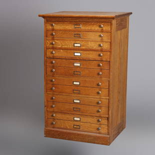
Sold2020Eight Drawer Oak Map, Art or Print File Cabinet, C 1910An antique map, art or print fining cabinet offers oak construction with eight drawers, brass pulls throughout, c1910. Measures- 45.5" H x 28" W x 22.75" D. ***IN-HOUSE SHIPPING & DELIVERY QUICK QUOTESee Sold Price
Sold20241816 MAP SOUTHERN PART OF RUSSIA or MUSCOVY in EUROPE copper engraving ANTIQUEAntique engraved map of Southern part of Russia from A General Atlas, Being A Collection Of Maps Of The World And Quarters, Their Principal Empires, Kingdoms, &c. Containing Fifty Eight Maps And ChartSee Sold Price
Sold2018Collection of Eight Antique Mourning Jewelry Itemsto include a low karat gold oval brooch with braided hair under glass in the center (.75 x 1 1/8 in.); a rectangular gold brooch with black enamel and braided hair under glass, testing 14KT (1 x 1.25See Sold Price
Sold2021Four Antique MapsFour antique maps. Including a very early hand made paper map of Florida and Virginia. Fragment of old newspaper on back dated 1630. Unframed, each approx H 21" W 24". All in excellent condition, minoSee Sold Price
Sold2023TWO ANTIQUE MAPS OF CHINA.Two antique maps of China, including Chinae by Abraham Ortelius, 1595, image 14.25” x 18.25”, with map of Eastern Asia, Le table de la region orientale, image 10” x 13.5”.See Sold Price
Sold2022CASED COLLECTION OF EIGHT ANTIQUE EUROPEAN GOLD COINS Mostly 19th Century Approx. 36.80 dwt.CASED COLLECTION OF EIGHT ANTIQUE EUROPEAN GOLD COINSMostly 19th Century"The Royal Gold Collection". Includes an Austrian 20 corona from 1915, Belgian 20 francs from 1875, French 20 francs from 1859,See Sold Price
Sold2019EIGHT ANTIQUE JADE PEBBLE SNUFF BOTTLESCollection of eight, antique 19th Century Chinese jade and jadeite snuff bottles, each of smooth pebble form and well-hollowed: grayish-white with wood bead stopper; celadon-gray with jade stopper; &#See Sold Price
Sold2021Collection of Eight Antique Korean Water DroppersA collection of eight antique Korean porcelain water droppers Joseon dynasty, 18th century used to drip a desired amount of water onto the inkstone. Water droppers were one of the simple and elegant iSee Sold Price
Sold2020Eight Antique 19th C Empire Style Side ChairEight Antique 19th C Empire Style Side Chair. Rocaille back splash motif. 34 inches x 19 inches x 22 inches. 17 inches from floor to seat.See Sold Price
Sold2018Morden: Antique Map of Florida & the Great Lakes, 16931693 map of Florida and the Great Lakes by Robert Morden. 5 x 5 inches. A very special map--one of the very earliest obtainable English maps of the American colonies. A Map of Florida and Ye Great LakSee Sold Price
Sold2023Eight Antique Arts & Crafts Limbert Style Mission Oak Celtic Cutout Chairs c1910An antique set of eight Mission Arts and Crafts dining chairs in the manner of Limbert offer oak construction with t-backs having cutout Celtic or Gothic clover (shamrock) and stylized cross, c1910. MSee Sold Price
Sold2021Eleven Antique Maps of EuropeEleven Antique Maps of Europe , 16th-18th c., incl. Ptolemy from 1541 (4); a Blaeu map of "Regno di Napoli", Hondius map of the Holy Land, de Wit map of Southern Spain, an undated manuscript map of MeSee Sold Price
Sold2022Eight Antique Grand Tour-Style BronzesEight Antique Grand Tour-Style Bronzes, incl. Warwick vase, the Dying Gaul, pair of wrestlers, and others, largest h. 5 1/4 in., w. 8 in., d. 5 1/2 in. Provenance: Estate of Highly Acclaimed New OrleaSee Sold Price
Sold2023Set of Eight Antique English Chippendale Style Mahogany Ribbon-Back Dining ChairsSet of Eight Antique English Chippendale Style Mahogany Ribbon-Back Dining Chairsmid 19th century, including two armchairs and six side chairs, the armchairs with relief carved and shaped arms with knSee Sold Price
Sold2022John SPEED: Two Antique Maps of IrelandTwo framed antique maps of Ireland by John Speed, a well known English cartographers circa 17th century. [Maps: 15" H x 20" W; Frames: 24" H x 28 1/2" W].See Sold Price
Sold2021Eight Antique Chinese Wood FiguresChina, ca. 18th-19th century. Consisting of eight carved wooden figures depicting dignitaries and scholars. Custom stands. MEASUREMENTS Height of tallest with stand: 7 3/4 inches / 19.5 cm SHIPPING $3See Sold Price
Sold2023Six Antique Maps of America Engravings, 19th c., H.- 7 1/4 in., W.- 4 1/2 in., Framed- H.- 15 in.,Six Antique Maps of America Engravings, 19th c., includes: "Map 8 1776 / Framing Declaration," "Map 5 1692 / New France: Map of the Discoveries of Marquette, La Salle and Other Frenchmen," "Map No. 12See Sold Price
Sold2020AN ANTIQUE MAP, "America," MILAN, CIRCA 1832,AN ANTIQUE MAP, "America," MILAN, CIRCA 1832, hand-colored lithograph on paper, titled "America," above "Dono," and the encyclopedic title, attributed as one of seven folding maps found in the thirtSee Sold Price
Sold20244 Antique Maps of Various LocationsFrench Map of Canada By Guillaume Del'Isle, Map Of Asia By Guiljelmo Blaeuw, Double Hemisphere map By Nicolao Visscher, Map Of The Holy Land Jerusalem, all maps are roughly 18" x 14"See Sold Price
May 12Ararity AuctionsEight Antique 18thC Early Chelsea Porcelain Pot De Creme Lidded Cups$65(3 bids)
Featured6 days LeftJasper52JAMAICA & HAITI. 'Hayti'. Caribbean West Indies. WELLER 1863 old antique map$35
Featured6 days LeftJasper52The Bahamas, Cuba & Bermuda "or Summer Islands". THOMSON 1817 old antique map$180
6 days LeftJasper52Descrittione dell' Isola Iamaica…. PORCACCHI. Jamaica 1590 old antique map$200
5 days LeftJasper52Royal Copenhagen. Eight antique and rare cups in hand painted porcelain. Museum Quality. 1790 s.$1,400
11 hrs LeftEric's Estate & JewelryEight Antique Swedish Flower Design Butter Spreader Knives in Sterling Silver$335


![John SPEED: Two Antique Maps of Ireland: Two framed antique maps of Ireland by John Speed, a well known English cartographers circa 17th century. [Maps: 15" H x 20" W; Frames: 24" H x 28 1/2" W].](https://p1.liveauctioneers.com/1221/264089/138965458_1_x.jpg?height=310&quality=70&version=1667576821)


