Sold2019MAP - Northern South America. SansonNorthern South America. Nicolas Sanson, Terre Ferme, Nouveau Royme de Grenade, &c., 1700 (circa). Hand Color. Very attractive small map of the northern part of South America, including most of modernSee Sold Price
2018Bonne: Antique Map of Royaume de Grenade, 1780TITLE/CONTENT OF MAP: 'Carte du Nouveau Royaume de Grenade, de la Nouvelle Andalousie et de la Guyane, avec les pays limitrophes qui en sont au sud' A map of the northern part of South America, includSee Sold Price
Sold20191794 Sea Chart of South Part Sumatra 18th Century Mapa very rare 18th century antique sea chart. This is an uncolored copper plate engraving. Image measures 24\" x 32.5\". This map has been matted and is ready for framing. A stunning chart of the southeSee Sold Price
Sold2023Eighteenth Century Map of North AmericaMap titled "Part of the United States of North America" published by John Stockdale, 15th November 1798, Piccadilly (London). Hand-colored map measures 16.5" x 19" (sight) and is housed in a frame meaSee Sold Price
Sold2023Antique French Engraving Felix Delamarche map South America 1838Charles-Francois Delamarche (1740-1817), the founder of the family firm was one of the most important French geographers and mapmakers of the second half of the eighteenth century. Successor to NicolaSee Sold Price
Sold2022Large Antique French 1748 D'anville Map of South America in a set of 3Jean-Baptiste Bourguignon d’Anville (1697-1782) was one of the foremost French geographers of the eighteenth century. He carried out rigorous research in order to create his maps, which greatlySee Sold Price
Sold2019Maps 19th Century. Mixed Lot of 7Lot of 7 Lithographed and Engraved Maps. Incl Europe Continent, Italy (Part Map) South Africa, Worcester/Gloucester, Huntingdonshire, Africa and UK. Examples by Stieler, Weekly Dispatch, Guthrie, JohnSee Sold Price
Sold2020Maps 19th Century. Mixed Lot of 8Lot of 8 Lithographed and Engraved Maps. Incl Europe Continent, Italy (Part Map) South Africa, Worcester/Gloucester, Huntingdonshire, Asia and UK. Examples by Stieler, Weekly Dispatch, Goldsmith, JohnSee Sold Price
Sold2018Maps 19th Century. Mixed Lot of 7Lot of 7 Lithographed and Engraved Maps. Incl Europe Continent, Italy (Part Map) South Africa, Worcester/Gloucester, Huntingdonshire, Africa and UK. Examples by Stieler, Weekly Dispatch, Guthrie, JohnSee Sold Price
Sold2022(HAWAII.) Group of 7 eighteenth and nineteenth century engraved maps.(HAWAII.) Group of 7 eighteenth and nineteenth century engraved maps. Vp, vd - La Perouse, after. Chart of the Parts of the Sandwich Islands. / Chart of the Sandwich Islands. 20¾x16¾ inchesSee Sold Price
Sold2017Moll maps of England and ScotlandHeading: Author: Moll, Herman Title: Two maps, of the northern and southern parts of Great Britain Place Published: London Publisher: Date Published: 1710-1714 Description:See Sold Price
Sold2022Map, Andalusia Castellum Gibraltar, Matthai (Matthias)Map, Andalusia Castellum Gibraltar, Matthai (Matthias) Seutteri, showing Gibraltar, South of Spain & several insets Minorca, Gibraltar, early part of the 18th Century, map is 19.25" by 22.25" (sight),See Sold Price
Sold20231850 map of W. Indies from Cowperthwait atlasNice example of Cowperthwait map of West Indies. Covers from Florida and the Bahamas south through the Caribbean islands of Cuba and Hispaniola (Haiti & the Dominican Republic) to the northern Part ofSee Sold Price
Sold20184 19th Century Maps The World, North/South U.S.4 19th Century Maps The World, North South U.S.. 4 Maps of The World, Political Map of The Southern Division of the U.S., The Northern Division of the U.S. and Political Map of South America and AfricSee Sold Price
Sold2024Asie. Tartarie #42 South Kazakhstan. North Kyrgyzstan. VANDERMAELEN 1827 mapCAPTION PRINTED BELOW PICTURE: 'Asie - Partie de la Tartarie - No. 42' Southern Kazakhstan and northern Kyrgyzstan, with the western part of Lake Balkash DATE PRINTED: 1827 IMAGE SIZE: Approx 51.0 x 5See Sold Price
Sold2022Antique 16th Century Map South AmericaTitle: Antique 16th Century Map South America Description:Antique 16th Century Map South America Circa Date: 1598 Condition of piece: Map displays toning, some water stains, wrinkles and creases,See Sold Price
Sold2023Eighteenth Century Map of North AmericaMap titled "NORTH AMERICA wherein are particularly distinguished the British Dominions, the United States, and the adjacent Spanish territories" by Thomas Kitchin and published by Laurie & Whittle, NoSee Sold Price
Sold2022(AFRICA.) Two hand-colored double-page engraved eighteenth-century maps of the continent.(AFRICA.) Two hand-colored double-page engraved eighteenth-century maps of the continent. Nuremberg, 1715-1730s - Homann Heirs. Africa Secundum Legitimas Projectionis Stereographicae. 20¾x24¼See Sold Price
Sold2022TWO 16TH TO 18TH CENTURY MAPSA lot of two sixteenth to eighteenth century maps. To include: "A Map of the Parish of St. Giles's" Sheet: 14" x 16.75" "Londinum Feracissimi", engravings on laid paper Sheet: 14.75" x 21"See Sold Price
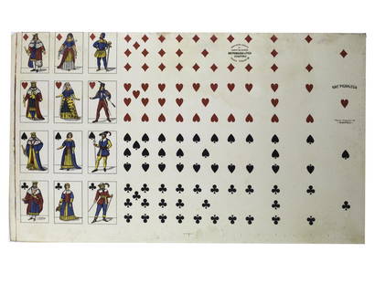
Sold2023Uncut sheet playing card French suite PIGNALOSA NAPOLI full bodyFrench suite edited by Edoardo Pignalosa, Rampe Brancaccio 76, Napoli , The cards are French-suited, elongated and narrow, and their design is reminiscent of several used in eighteenth century south aSee Sold Price
Sold2021Uncut sheet playing card French suite PIGNALOSA NAPOLIFrench suite edited by Edoardo Pignalosa, Rampe Brancaccio 76, Napoli , The cards are French-suited, elongated and narrow, and their design is reminiscent of several used in eighteenth century south aSee Sold Price
Sold2024Northern South America, 1843Title/Content of Map: Northern South America, 1843 Date Printed: 1843, Gotha Cartographer: F. von Stulpnagel / Adolf Steiler / Justus Perthes Size: 15 3/4" x 12 5/8" The upper half of Stulpnagel's higSee Sold Price
Sold2022EIGHTEENTH CENTURY TWO PART MAHOGANY CHEST ONEighteenth century two part mahogany chest on chest with pull out slide. Ht: 71.5" Wd: 43.5" Dpth: 22.5"See Sold Price
Sold2018de l'Isle: Antique Map of Northern South America, 1730Map: Carte de la Terre Ferme, du Perou, du Bresil, et du Pays des Amazones Cartographer: de l'Isle / Buache Place & Date: Paris / 1730/1782 Size: 22 3/8" x 19 1/2" Condition: wash color; overall age-tSee Sold Price
3 days LeftJasper52La partie méridionale du Brésil et du Perou. SANTINI/D'ANVILLE 1784 old map$80
3 days LeftJasper52Carte du Nouveau Royaume de Grenade… Colombia Venezuela Guyana. BONNE 1780 map$35
3 days LeftJasper52Partie méridionale Du Bresil… River Plate basin Brazil Uruguay. BONNE 1780 map$25
3 days LeftJasper52Northern South America . Andean states. Brazil. Amazonia. Relief. TIMES 1922 map$10
3 days LeftJasper52South America, North. Amazonia Brazil Venezuela Colombia Ecuador TIMES 1900 map$40
3 days LeftJasper52AMAZONIA showing "El Dorado?" & Missions. Brazil Ecuador Colombia SDUK 1874 map$120
3 days LeftJasper52AMAZONIA.Showing "El Dorado?", missions & tribes. Brazil Ecuador.SDUK 1844 map$130