Sold2018FRAGMENT MAP OF NEW YORK 18/19TH C.FRAGMENT MAP OF NEW YORK 18/19TH C. 19" X 23"See Sold Price
Sold2023Important lot 18th c documents from Hurley New York, many signatures of the significant families inImportant lot 18th c documents from Hurley New York, many signatures of the significant families in Ulster County, also hand drawn maps, stamped seals and small box of fragments of manuscripts and docSee Sold Price
Sold2018Map of Bronx New York c 1994Map of Bronx New York c 1994. Framed in a gold toned metal frame, printed map on paper depicting Bronx New York, with the street names listed alphabetically below. Measures approx 40 in tall by 27 inSee Sold Price
Sold2019North & South Carolina Early MapJohnson's North Carolina and South Carolina. Antique Map. A.J. Johnson, New York, c. 1866-70.. 18" x 26 1/2".See Sold Price
Sold2021c 1730 Seutter Map: Novi Belgii, in America ...Historic Maps c. 1730 Historic Rare Earlier State of Seutter's Important American Northeast Map & New York City Restitutio View c. 1730 Hand-Colored Copper-Engraved Map titled, "Recens Edita totius NoSee Sold Price
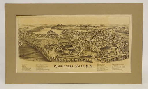
Sold2022Wappingers Falls New York Large ViewWappingers Falls, N.Y. Large Panorama Bird's-eye Map. L.R. Burleigh, Troy, New York, c. 1889. Antique print. 15" x 29".See Sold Price
Sold2019California Southwest Antique MapEarly map: California, also Utah, Nevada, Colorado, New Mexico and Arizona. Map by A.J. Johnson, New York, c. 1870. 18" x 26 1/2".See Sold Price
Sold2020Grp: 10 Maps of New York City 18th-Early 20th c.Group of 18th to early 20th century maps of New York City. Multiple are 19th-20th c. reprints of 17th-18th c. maps. Includes a small census map of New York City from 1850 with populations of New YorkSee Sold Price
Sold2019LARGE WALL MAP ULSTER COUNTY NEW YORKLARGE WALL MAP ULSTER COUNTY NEW YORK-OLIVER TILLSON, C. 1853 44" X 54"See Sold Price
Sold2021Very scarce NYC & Brooklyn by W. Williams, 1847Title: Very scarce NYC & Brooklyn by W. Williams, 1847 Description: Extremely scarce map “Cities of New-York and Brooklyn, &c.&c.,” drawn and engraved by W. Williams and published in 1847. This isSee Sold Price
Sold202119TH C. MAP OF NEW YORK & BROOKLYN (TEAR)19TH C. MAP OF NEW YORK & BROOKLYN (TEAR) 25.5" X 40"See Sold Price
Sold202219th C. Map of New YorkMap of New York dated 1890, showing political divisions and subdivisions November 1870, gilt framed under glass. [Art: 17" H x 38" W; Frame: 25 1/2" H x 47" W]. In good condition.See Sold Price
Sold2021Color map of California based on 1910 censusHeading: (California) Author: Title: Hammond's Complete Map of California Place Published: New York Publisher:C.S. Hammond & Co. Date Published: 1911 Description: Color foldingSee Sold Price
Sold2018Mitchell: Antique Map of New York City, 1860Title/Content of Map: 1860 Mitchell Map of New York -- Plan of New York & c. Date Printed: 1860, Philadelphia Cartographer: S Mitchell Size: 13.5 x 10.5 in. An excellent map of lower Manhattan, EllisSee Sold Price
Sold20191950s PanAm Route Map of Caribbean -- PanAmericanTitle/Content of Map: 1950s PanAm Route Map of Caribbean -- PanAmerican Flight Map of New York and Caribbean Date: late 1950s c. Cartographer: PanAm Size: 14x 24 in. folded out A very nice route map oSee Sold Price
Sold202419th c. Taghkanic Map19th c. map "Taghkanic" (New York). Sight 13 1/2" x 15 1/2", frame 18 1/2" x 20 1/2".See Sold Price
Sold202019th c. Map19th c. map of New York, H.S. Tanner, hand-colored lithograph. Sight 12 1/2" x 15 1/4".See Sold Price
Sold20181950s PanAm Route Map of Caribbeanan -- PanAmericanTitle/Content of Map: 1950s PanAm Route Map of Caribbeanan -- PanAmerican Flight Map of New York and Caribbeanan Date: late 1950s c. Cartographer: PanAm Size: 14x 24 in. folded out A very nice route mSee Sold Price
Sold20191950s PanAm Route Map of Caribbean -- PanAmericanTitle/Content of Map: 1950s PanAm Route Map of Caribbean -- PanAmerican Flight Map of New York and Caribbean Date: late 1950s c. Cartographer: PanAm Size: 14x 24 in. folded out A very nice route map oSee Sold Price
Sold20181950s PanAm Route Map of Caribbeanan -- PanAmericanTitle/Content of Map: 1950s PanAm Route Map of Caribbeanan -- PanAmerican Flight Map of New York and Caribbeanan Date: late 1950s c. Cartographer: PanAm Size: 14x 24 in. folded out A very nice route mSee Sold Price
Sold2018PanAm: Vintage Route Map of Caribbean, 1950sTitle/Content of Map: 1950s PanAm Route Map of Caribbean -- PanAmerican Flight Map of New York and Caribbeanan Date Printed: 1950s c. Cartographer: PanAm Size: 14 x 24 in. folded out A very nice routeSee Sold Price
2019Johnson’s map of New York and the Adjacent Cities,"c.Johnson’s map of New York and the Adjacent Cities,"c. 1860, by Johnson & Ward, H.- 18 in., W.- 27 in.See Sold Price
Sold2021FACSIMILE FRAGMENT PLAN OF THE CITY OF NEW YORK, 19TH CFACSIMILE FRAGMENT PLAN OF THE CITY OF NEW YORK, 19TH C., 20" X 25"See Sold Price
4 days LeftJasper521892 Black Map of US New England to New York, Pennsylvania, New Jersey and Canadian Maritimes plus$85
6 days LeftSloans & KenyonA BEAUTIFUL ENGROSSED MAP OF SUMMER PLAY LAND: THE NEW YORK, NEW HAVEN AND HARTFORD RAILROAD JOHN$1,000
4 days LeftJasper52c1863 Civil War era Virginia with Washington D.C. and View of The Capital. By C. Magnus$220
6 days LeftFreeman's | HindmanAn Egyptian Limestone Relief Fragment with the Cartouche of Rameses II$1,500
6 days LeftFreeman's | HindmanAn Egyptian Limestone Relief Fragment Depicting an Attendant Wearing a Head-Cone$1,000
Jun 06Freeman's | HindmanFAULKNER, William (1897-1962). Absalom, Absalom! New York: Random House, 1936.$300
Jun 06Freeman's | HindmanSTEVENSON, Robert Louis (1850-1894). Treasure Island. London, Paris & New York: Cassell & Company,$1,500
6 days LeftForum AuctionsAfrica.- Schillings (C.G.) In Wildest Africa, first American edition, New York & London, Harper &£75


![19th C. Map of New York: Map of New York dated 1890, showing political divisions and subdivisions November 1870, gilt framed under glass. [Art: 17" H x 38" W; Frame: 25 1/2" H x 47" W]. In good condition.](https://p1.liveauctioneers.com/1221/251963/131695197_1_x.jpg?height=310&quality=70&version=1656475639)


