Sold20241630 Mercator Map of Asia -- AsiaTitle: 1630 Mercator Map of Asia -- Asia Cartographer: G Mercator Year / Place: 1630, Amsterdam Map Dimension (in.): 7.3 X 10 in. This is an excellent smaller map of Asia. This map still show many mytSee Sold Price
Sold20221600 c. Mercator/Hondius Map of England and Wales --Title: 1600 c. Mercator/Hondius Map of England and Wales -- Anglia Regnum Cartographer: Mercator/Hondius Year / Place: 1595-1602, Amsterdam Map Dimension (in.): 13.8 X 18.2 in. This attractive map ofSee Sold Price
Sold20231607 MAP OF MOSCOVIA RUSSIA by G. MERCATOR - HONDIUS copper engraving ANTIQUEMAP OF MOSCOVIA (RUSSIA) by G. MERCATOR printed by JODOCUS HONDIUS in Amsterdam in 1607 Map size 5 1/4 by 6 3/4" Leaf size 8 by 12 1/4" Fold in the middle of the leaf (below map) Dampstain at the loweSee Sold Price
Sold2017ANTIQUE MAP OF AFRICA, GERHARD MERCATOR JR.17TH CFramed engraved hand colored map, after 1600, by Gerhard Mercator Jr (his grandfather was Gerhard Mercator, Flemish, 1512-1594), "Africa Ex magna orbis terre descriptione Gerardi Mercatoris desumpta,See Sold Price
Sold20241895 Cram World Map -- The World on Mercator ProjectionTitle: 1895 Cram World Map -- The World on Mercator Projection Cartographer: G Cram Year / Place: 1895, Chicago Map Dimension (in.): 17 x 24.3 in. Very nice, larger world map, color-coding the countriSee Sold Price
Sold20181695 Mercator Map of the Known World -- UniversalisTitle/Content of Map: 1695 Mercator Map of the Known World -- Universalis Tabula Iuxta Ptolemaeum Date: 1695, Amsterdam Cartographer: G Mercator Size: 13.7 x 18.6 in. This outstanding and decorative mSee Sold Price
Sold2020Mercator map of AsiaGerardus Mercator (1512-1594), ''Asia ex magna orbis terre descriptione Gerardi Mercatoris desumpta studio et industria G.M. Iunioris,'' Amsterdam, ca. 1613. map of Asia with hand-coloring, from MercaSee Sold Price
Sold2020Gerardus Mercator Map of Asia 1613Gerardus Mercator (1512-1594), "Asia ex magna orbis terre descriptione Gerardi Mercatoris desumpta studio et industria G.M. Iunioris," Amsterdam, ca. 1613. Hand colored map of Asia. Dimensions: Sight;See Sold Price
2017Hondius / Mercator: Map of Japan & Korea, 1630Map: 1630 Hondius / Mercator Map of Japan and Korea - Iaponia Cartographer: J. Hondius / G. Mercator Year / Place: 1630 c. Amstredam Map Dimensions: 13.4 x 17.4 in. Condition: Excellent - very good coSee Sold Price
Sold20221630 Mercator Map of Catalonia of Spain -- CataloniaTitle: 1630 Mercator Map of Catalonia of Spain -- Catalonia Cartographer: G Mercator Date/Place: 1630, Amsterdam Dimensions: 7.2 X 9.9 in. Description: This is an attractive map showing the province oSee Sold Price
Sold20241630 Mercator Map of Northern Germany -- Saxonia Inferior et Meklenborg Duc:Title: 1630 Mercator Map of Northern Germany -- Saxonia Inferior et Meklenborg Duc: Cartographer: G Mercator Year / Place: 1630, Amsterdam Map Dimension (in.): 7.2 X 9.8 in. This is an excellent map oSee Sold Price
Sold2016Belgii Inferioris, G. Mercator 1600'sDomestic: Free Shipping Title: Belgii Inferioris Maker: Gerard Mercator Date: Mid-1600's Size: 6.5 x 9 inches Title page to a Gerard Mercator atlas Gerard Mercator (1512-1594) was a cartographer who wSee Sold Price
Sold2017Hondius/Mercator: Antique Map of Japan & Korea, 1630Map: 1630 Hondius / Mercator Map of Japan and Korea - Iaponia Cartographer: J. Hondius / G. Mercator Year / Place: 1630 c. Amstredam Dimensions: 13.4 x 17.4 in. Condition: Sharp strike with the issuedSee Sold Price
Sold2018Mercator: Antique Map of Egypt and of N Africa, 1578Title/Content of Map: 1578 Mercator Map of Egypt and Parts of N Africa -- Afr. III Tab. Date Printed: 1578 Amsterdam Cartographer: G. Mercator Size: 13.25 x 18 in. This is a detailed map of NortheastSee Sold Price
Sold2024Abraham Ortelius Tempe "View of Mount Olympus" Colored Map Circa 1600Circa 1603 - Abraham Ortelius View of The Paradise of Tempe at the foot of Mount Olympus. This map was originally published in 1595. While we are unable to identify the exact date of this image, it isSee Sold Price
2021Michael Mercator RARE Antique Map of the AmericasAntique map of "America and New India" (America Sive India Nova) produced by Michael Mercator (c. 1567-1600), Gerard Mercator’s grandson. Hand colored engraved map. Duisburg, 1595 (Amsterdam, 1See Sold Price
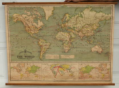
Sold2024Blackie (Pub) 1882 Large Map. World on Mercators ProjectionLithograph Maps Published 1882 by Blackie & Son, London for "The Comprehensive Atlas & Geography of the World" by W. G. Blackie. Paper Size: 22.5 x 15.5 inch (57 x 39cm) Good conditionSee Sold Price
Sold2015Bacon's Excelsior Map of The WorldOn Mercator's Projection, printed in London by G. W. Bacon & Co., Ltd., circa 1880. Chromolithograph laid on canvas with both original wood hangers. 39 1/2" x 30".See Sold Price
Sold2018LivoniaTitle/Content of Map: Livonia Cartographer: HONDIUS, JODOCUS/GERARD MERCATOR Height (inches): 14.3 Width (inches): 18.75Year: 1630 Mercator plate from Hondius's atlas.Original color. Text in Latin onSee Sold Price
Sold2018Four Small Antique Maps Pertaining to Cyprusas follows: Hogenberg, F. and Braun G. Famaugusta, copperplate engraving (Cologne, late 16th century) sheet, 8.75 x 14 in., giving a birds-eye view of the Cypriot port city; Mercator, Hondius, JanssonSee Sold Price
Sold2022[STREETER COPY] SEARCY, I. G. Map of Florida constructed principally from authentic documents in the[STREETER COPY] SEARCY, I. G. Map of Florida constructed principally from authentic documents in the Land office at Tallahassee by I. G. Percy. Published by I.G. Searcy Tallahassee & F. Lucas Jr., BalSee Sold Price
Sold2018Mercator map of the North Pole 1619Heading: Author: Mercator, Gerard Title: Septentrionalium Terrarum descriptio Place Published: Amsterdam Publisher: Date Published: 1595-[1619] Description: Copper-engravedSee Sold Price
Sold2020Mercator's map of Americas in 1595Heading: Author: Mercator, Michael Title: America siue India Nova ad Magnæ Gerardi Mercatoris aui Universalis imitationem in compendi um redacta. Per Michaelem Mercatorem Duysburgensem Place PublishSee Sold Price
Sold2019Mercator's map of Americas in 1595Heading: Author: Mercator, Michael Title: America siue India Nova ad Magnæ Gerardi Mercatoris aui Universalis imitationem in compendi um redacta. Per Michaelem Mercatorem Duysburgensem Place PublishSee Sold Price
BonhamsNONESUCH PRESS SHAKESPEARE (WILLIAM) The Works... The Text of the First Folio with Quarto varian...£400
2 days LeftJasper521881 Vuillemin World Map with French Colonies Shown -- Planisphere: Indiquant les Colonies Francises$30
Jun 12Dan Morphy AuctionsINDIAN TERRITORY - DEPARTMENT OF THE INTERIOR GENERAL LAND OFFICE, C.1883$100(1 bid)
3 days LeftJasper52Colonial Central Africa. Belgian Congo. French Equatorial Africa. TIMES 1922 map$15
3 days LeftJasper52North & West Africa. Dahomey. Gold Coast. Military Territory. THE TIMES 1922 map$20
3 days LeftJasper52Africa inc. discoveries of Livingstone Barth Vogel Chadda Exp. SWANSTON 1860 map$120
5 days LeftFreeman's | Hindman[MAP]. TODESCHI, Pietro. [Nova et Acurata Totius Americae Tabula auct. G.I. Blaeu] America quarta$5,000


![[STREETER COPY] SEARCY, I. G. Map of Florida constructed principally from authentic documents in the: [STREETER COPY] SEARCY, I. G. Map of Florida constructed principally from authentic documents in the Land office at Tallahassee by I. G. Percy. Published by I.G. Searcy Tallahassee & F. Lucas Jr., Bal](https://p1.liveauctioneers.com/292/250642/130213737_1_x.jpg?height=310&quality=70&version=1654271664)
![Mercator map of the North Pole 1619: Heading: Author: Mercator, Gerard Title: Septentrionalium Terrarum descriptio Place Published: Amsterdam Publisher: Date Published: 1595-[1619] Description: Copper-engraved](https://p1.liveauctioneers.com/642/122092/62169135_1_x.jpg?height=310&quality=70&version=1526256630)


![[MAP]. TODESCHI, Pietro. [Nova et Acurata Totius Americae Tabula auct. G.I. Blaeu] America quarta (1 of 1)](https://p1.liveauctioneers.com/197/329395/177650542_1_x.jpg?height=282&quality=70&version=1715364962)
![[MAP]. ORTELIUS, Abraham. Aevi Veteris, Typus Geographicus. 1601. (1 of 3)](https://p1.liveauctioneers.com/197/329395/177650532_1_x.jpg?height=282&quality=70&version=1715364962)