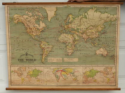
Sold2015Bacon's Excelsior Map of The WorldOn Mercator's Projection, printed in London by G. W. Bacon & Co., Ltd., circa 1880. Chromolithograph laid on canvas with both original wood hangers. 39 1/2" x 30".See Sold Price
Sold2022Two framed wall maps. Oarsmans map of the River Thames, 87 x 46cm, and Bacon's Excelsior Map ofTwo framed wall maps. Oarsmans map of the River Thames, 87 x 46cm, and Bacon's Excelsior Map of Norfolk and Suffolk, 113 x 89cm (2)See Sold Price
Sold2021Seven Vintage Pull Down Maps.A.J. Nystrom & Co United States and Mexico, 60 x 40 inches. Bacon's Standard Map of Africa, 50 x 34 inches. Bacon's Standard Map of the World in Hemispheres, 40 x 48 inches. Bacon's StSee Sold Price
Sold20211892 World Hemispherical MapTitle: 1892 World Hemispherical Map Medium: Ink on Paper Dimensions: 19"X13.5" Description: World Hemispherical map dated 1892. Part of Bacon's Commercial and Library Atlas of the World. Published bySee Sold Price
Sold20211892 Map of the Ancient WorldAuthor: Bacon Title: 1892 Map of the Ancient World Materials: Ink on Paper Size/Dimensions: 13.5"X11" Description: Map of the Ancient World dated 1892. Part of Bacon's Commercial and Library Atlas ofSee Sold Price
Sold20211892 Map of PalestineTitle: 1892 Map of Palestine Author: Bacon Medium: Ink on Paper Dimensions: 13.5"X21" Description: Map of Palestine dated 1892. Part of Bacon's Commercial and Library Atlas of the World. Published bySee Sold Price
Sold20211892 Map of Persia and AfghanistanTitle: 1892 Map of Persia and Afghanistan Medium: Ink on Paper Dimensions: 21"X13.5" Map of Persia and Afghanistan dated 1892. Part of Bacon's Commercial and Library Atlas of the World. Published by GSee Sold Price
Sold20211892 Map of the MediterraneanAuthor: Bacon Title: 1892 Map of the Mediterranean Medium: Ink on Paper Dimensions: 21"X13.5" Map of the Mediterranean region dated 1892. Part of Bacon's Commercial and Library Atlas of the World. PubSee Sold Price
Sold20211892 Map of Japan and KoreaAuthor: Bacon Title: 1892 Map of Japan and Korea Medium: Ink on Paper Dimensions: 13.5"X21" Map of Japan and Korea dated 1892. Part of Bacon's Commercial and Library Atlas of the World. Published by GSee Sold Price
Sold20211892 Map of ChinaAuthor: Bacon Title: 1892 Map of China Materials: Ink on Paper Size/Dimensions: 13.5"X21" Description: Map of China dated 1892. Part of Bacon's Commercial and Library Atlas of the World. Published bySee Sold Price
Sold20211892 Egypt MapAuthor: Bacon Title: 1892 Egypt Map Medium: Ink on Paper Dimenions: 13.5"X21" Description: Map of Egypt dated 1892. Part of Bacon's Commercial and Library Atlas of the World. Published by G.W. Bacon iSee Sold Price
Sold20211892 Cuba and Jamaica MapAuthor: Bacon Title: 1892 Cuba and Jamaica Map Medium: Ink on Paper Dimensions: 21"X13.5" Map of Cuba and Jamaica dated 1892. Part of Bacon's Commercial and Library Atlas of the World. Published by G.See Sold Price
Sold20211892 Map of Euro-AsiaTitle: 1892 Map of Euro-Asia Medium: Ink on Paper Dimensions: 19"X13.5" Description: Map of Europe and Asia dated 1892. Part of Bacon's Commercial and Library Atlas of the World. Published by G.W. BacSee Sold Price
Sold20211892 India MapsTitle: 1892 India Maps Author: Bacon Materials: Ink on Paper Dimensions: 21"X13.5" Description: Maps of India, North and South dated 1892. Part of Bacon's Commercial and Library Atlas of the World. PuSee Sold Price
Sold2022MAP, World, BellinWorld. Jacques Nicolas Bellin, Carte Reduite des Parties Connues du Globe Terrestre Dressee au Depost des Cartes Plans et Journaux de la Marine..., 1755 (dated). Hand Color. This is the rare first ediSee Sold Price
Sold20231939 Chase World Pictorial Map - World Wonders A Pictorial Map Designed and drawn by Ernest DudleyTitle: 1939 Chase World Pictorial Map - World Wonders A Pictorial Map Designed and drawn by Ernest Dudley Chase Cartographer: E D Chase Year / Place: 1939 Map Dimension (in.): 27.5 X 17.5 in. This supSee Sold Price
Sold2017Tallis World Map World on Mercator's Projection 1851Tallis World Map The World on Mercator's Projection 1851 . J. Tallis, 1851 London, 10.5 X 14 In.. This Is a Decorative and Striking Steel Engraved World Map That Was Produced from the Same Plate UsedSee Sold Price
Sold2021MAP, World, SchreiberWorld. Johann Georg Schreiber, Globus Terrestris ex Probatissimis Recentiorum Geographorum Observationibus Confectus cum Systemate Copernicano..., 1750 (circa). Hand Color. This charming double hemispSee Sold Price
Sold2022MAP, World, JannotWorld. J.B. Jannot, Le Tour du Monde en 120 Images Grand Concours du Chocolat Menier, 1956 (circa). Printed Color. This attractive and novel pictorial map of the world was created by J.B. Jannot and pSee Sold Price
Sold2023Lizars, Daniel 1831 LG Rare HC Map. World on Mercator's ProjectionLarge Folio Copper Engraved Map Published 1831-2 by John Hamilton, Successor to Daniel Lizars, Edinburgh for "The Edinburgh Geographical and Historical Atlas..." First Edition by Daniel Lizars. Very fSee Sold Price
Sold2021Bacon's Map of Manchester Corrected to the PresentPublication Date: c1910 Title: Bacon's Map of Manchester Corrected to the Present Time... Cartographer: Bacon, G.W. & Co.G.W. Bacon & Co. Height: 14.2 Width: 21.75 Highly detailed city plan folding inSee Sold Price
Sold20231810 Modern Geography America MAP + World Map Massachusetts Elijah Parish1810 Modern Geography America MAP + World Map Massachusetts Elijah Parish Elijah Parishs “New System of Modern Geography” is an early 19th-century American geography textbook. Published inSee Sold Price
Sold2021Guthrie, William 1806 Map. World HemispheresCopper Engraved Map Published 1806, London for "A New Geographical, Historical and Commercial Grammar..." by William Guthrie. The maps are by John Senex, Thomas Kitchin and others. Folds as issued. PaSee Sold Price
Sold20181915 Bacon Map of SouthEast England for Cyclists andReserve Reduced! Title/Content of Map: 1915 Bacon Map of SouthEast England for Cyclists and Autos -- Bacon's Cycling and Motoring Road Map of South East England Sheet No.6 (of England) … Fifty MilesSee Sold Price
23 hrs LeftRapid Estate Liquidators and Auction GalleryVintage Cricket Gillette World Map Lighter Holder$10
6 days LeftJasper52WEST INDIES. Cuba Jamaica Lesser Antilles. Inset Havana Kingston. BACON 1893 map$20
2 days LeftRapid Estate Liquidators and Auction Gallery6 1980s 1990s National Geographic Magazines A$35
2 days LeftTrillium Antique Prints & Rare BooksPtolemy & Magini, pub. 1620 - Map of the World$50(1 bid)
May 17Royal Treasures Warehouse LLC1530s Old Map of the World as seen from the North & South Poles$100
May 16Potter & Potter AuctionsLANGENECKERT. It’s A Dog’s World. 1968. St. Louis: Ralston ...$100