Sold20201884 Map of West TexasAuthor: Cram Title: 1884 Map of West Texas Medium: Ink on Paper Dimensions: 14.5"X21.5" Map of the West portion of Texas dated 1884. Engraved and published by George Cram in Chicago. Part of his WorldSee Sold Price
Sold2021West Texas 1901Title/Content of Map: West Texas 1901 Date Printed: 1901Material/Medium: Paper Size: approx 14x21.5 inches Fort Dearborn Publ. Co., The National Standard Atlas Reserve: $30.00 Shipping: Domestic: FlSee Sold Price
Sold20211890 Map of West TexasTitle: 1890 Map of West Texas Medium: Ink on Paper Dimensions: 14.5"X22.5" Description: Map of West Texas dated 1890. Engraved and published by George Cram in Chicago. Part of his Family Atlas. DoubleSee Sold Price
Sold2017Rand Mcnally & Co.'s Railroad Map Of West TexasRailroad Map of West Texas Rand, McNally & Co. c. 1880, 21 x 14.25 in Please note that this lot has a confidential reserve. When you leave a bid in advance of the auction, submit your maximum. Jasper5See Sold Price
Sold20211901 West Texas MapAuthor: Cram Title: 1901 West Texas Map Medium: Ink on Paper Dimensions: 14.5"X22.5" Map of West Texas dated 1901. Printed and published by George Cram in Chicago. Part of his Family Atlas. Double folSee Sold Price
Sold2019U S Coast Survey 1896 LG Map. West USA California Texas"Sketch of General Progress June 30. 1896." Showing Central and Western US, with part of Mexico. From Mississippi/Wisconsin through to West Coast. Large Lithograph Map Published 1896, Washington for "See Sold Price
Sold20221850 James Map of US West and Texas -- A New Map of Mexico, California & OregonTitle: 1850 James Map of US West and Texas -- A New Map of Mexico, California & Oregon Cartographer: J A & U P James Year / Place: 1850, Cincinnati Map Dimension (in.): 12.5 X 9.5 in. This is an excelSee Sold Price
Sold2022Scarce Texas map (western part) from Asher & AdamsLarge double-page map of Western Portion of Texas with inset of extreme western tip of the state. Shows towns, proposed railroad lines and river, including the Colorado River and the Rio Grande. The fSee Sold Price
Sold2022(WEST--TEXAS.) [George F. Folsom.] Mexico in 1842 . . . to which is Added, an Account of Texas and(WEST--TEXAS.) [George F. Folsom.] Mexico in 1842 . . . to which is Added, an Account of Texas and Yucatan. Folding hand-colored map. 256 pages. 12mo, publisher's cloth, minor wear; minor foxing; earlSee Sold Price
Sold2024Raymond's Geologic Map of the United States, 1873. [177507]US Mineral Commissioner Rossiter W. Raymond's Geologic Map of the United States, 1873, published originally in the 1874 volume of Mineral Resources West of the Rocky Mountains. 36 x 25", folds t fix tSee Sold Price
Sold2024West India Islands. Caribbean. La Salle settlement in Texas. LIZARS 1842 mapTITLE/CONTENT OF MAP: 'West India Islands and adjacent coasts of the United States, Mexico, Guatimala & Colombia' The map notes anecdotally the location of René Robert Cavelier, Sieur de La SalleSee Sold Price
Sold20231866 Schönberg's Early Map of Texas Historic Vintage Inspired Map1866 Schönberg's Early Map of Texas Historic Vintage Inspired Map As settlers spread west, Schönberg's map of Texas shows the growing state of Texas and the contemporary counties as ofSee Sold Price
Sold20221866 Schönberg's Early Map of Texas Historic Vintage Inspired Map1866 Schönberg's Early Map of Texas Historic Vintage Inspired Map As settlers spread west, Schönberg's map of Texas shows the growing state of Texas and the contemporary counties as ofSee Sold Price
Sold2023Box of Assorted Maps [147388]Box of approx 120 maps,1960's to 1970's? Folding road maps of the West, Big Bend National Park, Missouri, Texas, Wyoming, Colorado, Yellowstone, S. Dakota, Colorado Parks and more.See Sold Price
Sold20211847 map showing east Texas/Indian TerritoryInteresting map of the southern U. S. in 1847. Map by Cady & Burgess from Roswell SmithÂ’s 1847 Quarto Atlas. Eastern portion of Texas shown along with most of Indian Territory. Also includes ArkanSee Sold Price
Sold20171874 Map of Boston. GM Hopkins. This map includes1874 Map of Boston. GM Hopkins. This map includes portions of cities around Boston such as Cambridge, Charleston, Somerville, Chelsea, Brighton, Brookline, West Roxbury, Dorchester, and South Boston.See Sold Price
Sold2020New Map of That Portion of North America 1851New Map of That Portion of North America Exhibiting the United States and Territories, the Canadas, New Brunswick, Nova Scotia and Mexico also Central America and the West India Islands, 1851, Jacob MSee Sold Price
Sold2020New Map of That Portion of North America 1854New Map of That Portion of North America Exhibiting the United States and Territories, the Canadas, New Brunswick, Nova Scotia and Mexico also Central America and the West India Islands, 1854, Jacob MSee Sold Price
Sold2018Asher & Adams: Antique Map of Indian Territory, 1874Title/Content of Map: 1874 Asher & Adams Indian Territory Map -- Asher & Adams Indian Territory and Texas North West Portion Date Printed: 1874, New York Cartographer: Asher & Adams Size: 16.3 x 23.2See Sold Price
Sold2020Map of Mexico and Texas c.1845Heading: (Texas) Author: Wyld, James Title: Republic of Mexico and Texas Place Published: London Publisher: Date Published: c.1845 Description: Engraved map, with Mexico portionSee Sold Price
Sold20231742 Map of Part Of New York 1742 David GrimMap of Part Of New York- Showing the site of the present Park the Collect and Little Collect Ponds; and a portion of the west side of Broadway. 1742 David Grim 11x7, hand colored with details of an agSee Sold Price
Sold20212 Large Scrapbooks of Shell Oil 30's US Road Map BooksPair of Folio Style Shell Oil 1930s US Road Map Books. These map booklets, with tabs for various US States like North Carolina, South Carolina, Virginia, West Virginia, and Texas, were published by ShSee Sold Price
Sold2021EMANUAL BOWEN America & West Indies MapEMANUAL BOWEN America & West Indies Map, inscriptions to upper portion read ‘Particular Draughts and Plans of some of the Principal Towns and Harbours belonging to the English, French, and SpaniardsSee Sold Price
Sold2016Map of the United States 1835Map: Map of the United States Maker: Anonymous Size: Folio - 11.2 inches high x 14.6 inches wide Date: 1835 Map covering U.S. west to Rocky Mtns. Large NW Terr.; huge MO Terr. Texas part of Mexico asSee Sold Price
Jun 12Dan Morphy AuctionsGEOLOGY OF THE BLACK AND GRAND RAPIDS OF TEXAS INCLUDING THE EASTERN AND WESTERN CROSS TIMBERS,$100
2 days LeftJasper521898 Rand McNally Map of Texas [verso] Indian Territory and Oklahoma -- Texas [verso] Oklahoma and$70
4 days LeftZikorn Arts & History ObjectsWest Indies, Eastern Cuba 1881 British Admiralty Nautical Map$100
4 days LeftZikorn Arts & History ObjectsWest Indies, Western Cuba 1879 British Admiralty Nautical Map$100
4 days LeftPotter & Potter AuctionsSTORM, Mark. Official Texas Brags Map of North America. 194...$200(1 bid)
2 days LeftJasper521760 Kitchin Map of the German Romantic Road Area -- A Map of the Circle of Franconia from the$45
5 days LeftLEAP Auctions40 West Texas & New Mexico Authentic Arrowheads & Bird Point Artifacts in Display Case$20(1 bid)
5 days LeftLEAP Auctions(2) Decorative Frames of West and New Mexico Authentic Arrowheads Artifacts$20
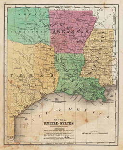
2 days LeftJasper521887 Cram Map of Texas [verso] Indian Territory [verso] Arkansas -- Texas [verso] Indian Ty. [verso]$95


![(WEST--TEXAS.) [George F. Folsom.] Mexico in 1842 . . . to which is Added, an Account of Texas and: (WEST--TEXAS.) [George F. Folsom.] Mexico in 1842 . . . to which is Added, an Account of Texas and Yucatan. Folding hand-colored map. 256 pages. 12mo, publisher's cloth, minor wear; minor foxing; earl](https://p1.liveauctioneers.com/199/242021/125450317_1_x.jpg?height=310&quality=70&version=1648143591)
![Raymond's Geologic Map of the United States, 1873. [177507]: US Mineral Commissioner Rossiter W. Raymond's Geologic Map of the United States, 1873, published originally in the 1874 volume of Mineral Resources West of the Rocky Mountains. 36 x 25", folds t fix t](https://p1.liveauctioneers.com/2699/324080/174413241_1_x.jpg?height=310&quality=70&version=1711485545)


![Box of Assorted Maps [147388]: Box of approx 120 maps,1960's to 1970's? Folding road maps of the West, Big Bend National Park, Missouri, Texas, Wyoming, Colorado, Yellowstone, S. Dakota, Colorado Parks and more.](https://p1.liveauctioneers.com/2699/299063/159201775_1_x.jpg?height=310&quality=70&version=1692045182)


![1898 Rand McNally Map of Texas [verso] Indian Territory and Oklahoma -- Texas [verso] Oklahoma and (1 of 2)](https://p1.liveauctioneers.com/5584/328338/176911581_1_x.jpg?height=282&quality=70&version=1715113718)


![1887 Cram Map of Texas [verso] Indian Territory [verso] Arkansas -- Texas [verso] Indian Ty. [verso] (1 of 3)](https://p1.liveauctioneers.com/5584/328338/176911685_1_x.jpg?height=282&quality=70&version=1715113718)
