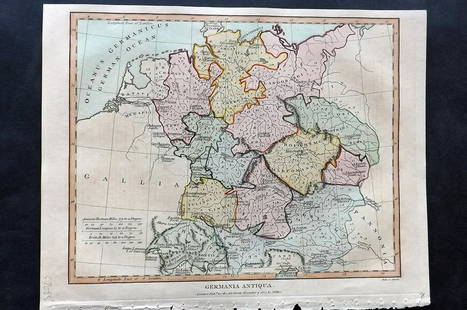
Sold2021Wilkes, John 1807 Hand Col Map. Ancient Germany"Germania Antiqua" Finely Hand Colored Copper Engraved Map Published 1796-1828 London for "Encyclopaedia Londinensis, or universal dictionary of arts, sciences and literature" by John Wilkes et al. PaSee Sold Price
Sold2019Delamarche, Felix 1829 Lot of 3 Maps. Europe & Germany"L'Europe a l'Epoque du demembrement de l'Empire de Charlemagne" "L'Europe avan l'Invasion des Barbares" and "Germania Antiqua et regiones Danubium" Copper Engraved Maps Published 1829, Paris for "AtlSee Sold Price
Sold2019Delamarche, Felix 1829 Maps (2) Ancient France, Germany"Germania Antiqua" and "Galliae Antiquae" Copper Engraved Maps Published 1829, Paris for "Atlas de La Geographie..." by Felix Delamarche. Contemporary outline hand colour. Centre fold as published. PaSee Sold Price
Sold2021Antique Map GERMANIA ANTIQUASize: 11 X 8.5 inches approx. Unframed. Printed 1826.See Sold Price
Sold2021Guthrie, William 1806 Map. GermanyCopper Engraved Map Published 1806, London for "A New Geographical, Historical and Commercial Grammar..." by William Guthrie. The maps are by John Senex, Thomas Kitchin and others. Folds as issued. PaSee Sold Price
Sold2021Guthrie, William 1798 Map. GermanyCopper Engraved Map Published 1798, London for "A New Geographical, Historical and Commercial Grammar..." by William Guthrie. The maps are by John Senex, Thomas Kitchin and others. Folds as issued. PaSee Sold Price
Sold2021Guthrie, William 1798 Map. GermanyCopper Engraved Map Published 1798, London for "A New Geographical, Historical and Commercial Grammar..." by William Guthrie. The maps are by John Senex, Thomas Kitchin and others. Folds as issued. PaSee Sold Price
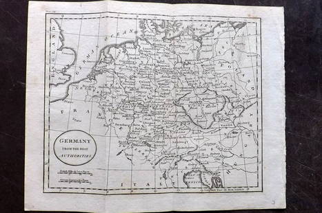
Sold2021Barlow 1807 Antique Map. GermanyCopper Engraved Map Published 1807 by Brightly & Kinnersley, Bungay, England for "A General View of the World, Geographical, Historical and Philosophical" by The Rev. E. Blomfield. Engraved by Barlow.See Sold Price
Sold2022Guthrie & Kitchin 1782 Map. GermanyCopper Engraved Map Published 1782, London for "A New Geographical, Historical and Commercial Grammar..." by William Guthrie. The maps are by John Senex, Thomas Kitchin and others. Folds as issued. PaSee Sold Price
Sold2022LUFTWAFFE FLIGHT MAP OF GERMANY, FRANCE AND ENGLANDDouble-sided ‘Luft-Navigationskarte’ (‘Air Navigation Map’), 26.5 x 24 in., printed on weatherproofed canvas and produced by the General Staff of the Luftwaffe, circa 1941. BSee Sold Price
Sold2023Exquisite vertical format vintage map of Germany – 1865Beautiful and large two-page map of Germany in an unusual vertical format. Covers the region from the Baltic Sea to the Adriatic Sea. This historical document shows the two great regions of Germany, PSee Sold Price
Sold20241730 antique MAP of GERMANY Netherlands Belgium Luxemburg 18th CENTURYNetherlands, Belgium, Luxemburg Tabula generalis totius Belgii qua Provinciae XVII Infer. Germania olim sub S.R.I. Vircula Burgundiae by Homann, Johann Baptist, 1663-1724 Nuremberg, 1730 Size 20.5 bySee Sold Price
Sold2021Kitchin, Thomas 1785 Map of Germany & Netherlands"Germany with the Seven United Provinces" Copper Engraved Map Published 1783-85, London for "A New Geographical, Historical and Commercial Grammar..." by William Guthrie. Drawn and Engraved by ThomasSee Sold Price
Sold2021Barlow 1807 Antique Map of GermanyCopper Engraved Map Published 1807 by Brightly & Kinnersley, Bungay, England for "A General View of the World, Geographical, Historical and Philosophical" by The Rev. E. Blomfield. Maps Engraved by BaSee Sold Price
Sold2022Lizars, Daniel 1831 LG Rare HC Map. Franconia, GermanyLarge Folio Copper Engraved Map Published 1831-2 by John Hamilton, Successor to Daniel Lizars, Edinburgh for "The Edinburgh Geographical and Historical Atlas..." First Edition by Daniel Lizars. Very fSee Sold Price
Sold2023Lizars, Daniel 1831 LG Rare HC Map. Franconia, GermanyLarge Folio Copper Engraved Map Published 1831-2 by John Hamilton, Successor to Daniel Lizars, Edinburgh for "The Edinburgh Geographical and Historical Atlas..." First Edition by Daniel Lizars. Very fSee Sold Price
Sold2018Ptolemy/Magini: Antique Map of France, Germany, 1598Map: Tavola della Gallia, Terza dell'Europa Tavola della Gran Germania, Quarta dell'Europa Cartographer: Magini / Porro / Galignani Fratelli Place & Date: Venice / 1598 Size: 6 5/8" x 5 1/8" (maps); 7See Sold Price
Sold2018Arrowsmith: Antique Map of Ancient Germany, 1828TITLE/CONTENT OF MAP: 'Germania; Vel Regiones intra Rhenum f1. Oceanum, Sinum Codanum, Vistulam f1. Montes Sarmaticos et Danubium f1. Sitae' DATE PRINTED: 1828 IMAGE SIZE: Approx 25.5 x 28.5cm, 10 x 1See Sold Price
Sold2022Lizars, Daniel 1831 LG Rare HC Map. Upper Saxony, GermanyLarge Folio Copper Engraved Map Published 1831-2 by John Hamilton, Successor to Daniel Lizars, Edinburgh for "The Edinburgh Geographical and Historical Atlas..." First Edition by Daniel Lizars. Very fSee Sold Price
Sold2023Lizars, Daniel 1831 LG Rare HC Map. Upper Saxony, GermanyLarge Folio Copper Engraved Map Published 1831-2 by John Hamilton, Successor to Daniel Lizars, Edinburgh for "The Edinburgh Geographical and Historical Atlas..." First Edition by Daniel Lizars. Very fSee Sold Price
Sold20241839. Ancient Germania and Central Europe by MoninTitle/Content: 1839. Ancient Germania and Central Europe by Monin Date: 1839 Medium: Hand colored, engraved Dimensions: 17 1/2" x 12 1/2" Description: Map of Ancient tribal Germany and Central Europe.See Sold Price
Sold2020Philipp Cluver "Sicilia Antiqua" 1619Philipp Cluver (1580-1622), "Sicilia Antiqua; cum minoribus insulis, ei adjacentibus. Item, Sardinia et Corsica," 1619. A fine volume on historical Sicily with lovely maps. SKU: 02087See Sold Price
Sold2023Antique Map Print - Europe - Map of Silesia - Poland - Czech Republic - WroclawDescription: Map of Silesia. Silesia is a historical region of Central Europe that lies mostly within Poland, with small parts in the Czech Republic and Germany. Date: 17th Century Material: Paper DimSee Sold Price
Sold2019Barlow 1807 Group of 3 European MapsIncl Germany, Switzerland, and France. Copper Engraved Maps Published 1807 by Brightly & Kinnersley, Bungay, England for "A General View of the World, Geographical, Historical and Philosophical" by ThSee Sold Price
6 days LeftRbfineartsHistorical Map of the State of Kentucky by Karl Smith 1933 Daniel Boone & Companions View$30(2 bids)
2 days LeftJasper52Large Antique French map GERMAN EMPIRE 1792 colored by POIRSON engraver Basset$170
2 days LeftJasper521552 Munster Map of Southern Germany and Switzerland -- Suevia et Bavaria XII Nova Tabula$160
2 days LeftJasper521593 de Jode Maps of Eastern Germany (Saxony Area) and Western Germany -- Mansfeldiae Comitatus ...$700
2 days LeftJasper521720 antique MAP of LOWER SAXONY GERMANY 18th CENT. Circulus Saxoniae inferioris$75
Jun 15Riverfront AuctionsC. 1730 Map of North Rhine-Westphalia, Germany after N. Sanson by Covens and Mortier$5
Featured2 days LeftJasper521759 HISTORY OF THE WORLD in GERMAN antique ILLUSTRATED w/ MAP of ARABIA vellum$200
2 days LeftJasper521552 Munster Map of Netherlands and Western Germany -- Brabantia III Rheniet X Nova Tabula$240