Sold2015JOHN DE BURGH PERCEVAL (1923 – 2000) Ram Tea PartyJOHN DE BURGH PERCEVAL (1923 – 2000) Ram Tea Party and Dancing Lady photolithograph 42 x 67cmSee Sold Price
Sold2024AFTER THOMAS F. BEACH (1738-1806) / Early Frame"Hon Henry de Burgh" pastel 29 x 24 inches. presented in a (18th c) carved and gilt frame 34 1/2 x 29 1/2 inchesSee Sold Price
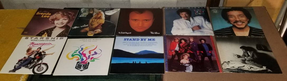
Sold202010 Vintage Record Albums10 Vintage Record Albums (Billy Joel, Starship, Lionel Richie, Smokey Robinson, Kim Carnes, Phil Collins, Heart, Stand by Me, Brenda Lee, Chris De Burgh)See Sold Price
Sold2024L'Irlanda o'vero Hibernia. Ireland. DE ROSSI 1689 old antique map plan chartTITLE/CONTENT OF MAP: L'Irlanda o'vero Hibernia [Ireland, or Hibernia] DATE PRINTED: 1689 IMAGE SIZE: Approx 59.0 x 45.0cm, 23.25 x 17.75 inches (Large) TYPE: Antique 17th century folio atlas map CONDSee Sold Price
Sold2021Beautiful Imperial Ireland "DE" Stainless Steel InoxBeautiful Imperial Ireland "DE" Stainless Steel Inox Multi-Tool Camp Knife Please view all photos as they are part of the description and condition of this Item, Feel free to contact me with questionsSee Sold Price
Sold2021Beautiful Imperial Ireland "DE" Stainless Steel InoxBeautiful Imperial Ireland "DE" Stainless Steel Inox Multi-Tool Camp Knife New Please view all photos as they are part of the description and condition of this Item, Feel free to contact me with questSee Sold Price
Sold2023Antique Map of Ireland, Frederick de WittDutch, 1629-1706..REGNI et INSULAE HIBERNIAE, latter 17th century, hand colored copper plate engraving, sight 28 x 19.5 in..toning, areas of foxing and discoloration, creases, under glass, not examineSee Sold Price
Sold2023[7] Pocket Knives: Imperial, Ireland Utility, Recuerdo De Espang Utility, Stainless, Enamel, Razor,[7] Pocket Knives: Imperial 3 1/4 in. x 5/8 in. , Imperial Ireland Utility 3 5/8 in. x 3/4 in. , Recuerdo De Espang Utility in case 4 1/4 in. x 1 3/4 in. , Stainless 2 7/8 in. x 7/8 in., Enamel 2 5/8See Sold Price
Sold2016Benjamin Chandlee Surveyor\\\'s CompassFancy engraved silvered dial with rose points, degrees, and fleur-de-lis. Benjamin emigrated from Ireland in 1702 to Nottingham (Chester County) Maryland. Son Benjamin worked there and in Baltimore inSee Sold Price
Sold2017Pieter van der Aa: Map of Ireland, 1713Map: L'Irlande Suivant Les Nouvelles Observations De Messrs De l'Academie Royale Des Sciences, Etc. Augmentees De Nouveau. (1713 Map of Ireland) Cartographer: Pieter Van Der Aa Date: 1713 Size: 8.75 xSee Sold Price
Sold2023Henri Abraham Chatelain (1684-1743) Map of IrelandHenri Abraham Chatelain (French 1684-1743) Nouvelle Carte De L'Irlande, ou on Remarque l'Etat Present De Cette Isle- Map of Ireland from "Atlas Historique" first published in 1721 - This three part maSee Sold Price
Sold20231876 Victorian 1ed Acre-ocracy of England Nobles Bateman Landowners of Britain1876 Victorian 1ed Acre-ocracy of England Nobles Bateman Landowners of Britain The Great Landowners of Great Britain and Ireland is an important 19th-century reference of the most wealthy individuals,See Sold Price
Sold20151st Viscount Fane (1676-1744) Letter[GREAT BRITAIN] Charles Fane, 1st Viscount Fane PC (Ire) (1676-1744) English courtier, politician and a landowner in both England and Ireland. Fane or ffane was baptised at Basildon in Berkshire on 30See Sold Price
Sold20211708 Chatelain Map of Ireland -- Carte Ancienne etTitle: 1708 Chatelain Map of Ireland -- Carte Ancienne et Moderne de l'Irlande, avec Quelques Remarques sur son Gouvernement et sur l'Etat Present de Cette Isle Cartographer: H Chatelain Year/Place: 1See Sold Price
Sold2018de la Tour / Desnos: Antique Map of Ireland, 1771Title/Content of Map: 'L'Irlande divisée par provinces Civiles et Ecclesiastiques. Par Mr. Brion Ingénieur-Géographe du Roi, à Paris, Chez le S Desnos Ing? Géog? pour les Globes et Sphères, RueSee Sold Price
Sold2022Alfred de Bréanski (1852-1928) In the Gap of Dunloe, Killarney, Ireland Oil on canvas, 60.5 xAlfred de Bréanski (1852-1928) In the Gap of Dunloe, Killarney, Ireland Oil on canvas, 60.5 x 91.5cm (23¾ x 36) Signed; also signed and inscribed verso Provenance: With Roberts Art Gallery,See Sold Price
Sold2020Alfred Fontville de Bréanski (British, 18Alfred Fontville de Bréanski (British, 1877-1955) The Upper Lake at Killarney, Ireland Oil on canvas 24 x 36 inches (61.0 x 91.4 cm) Signed lower right: A de Bréanski Signed and titled oSee Sold Price
Sold2016(2) Chinese blanc de chine figures(2) Chinese blanc de chine figures, 19th/20th c., warrior and an immortal, unmarked, larger: 13"h x 6.5"w x 4.5"d (samurai), 12"h x 4.5"w x 3.25"d Provenance: The Estate of Gilbert Ireland, NY; MillicSee Sold Price
Sold2018GB used in Ireland: £1 used in Dublin1891 £1 green superb used with neat, upright cds DUBLIN / SORTING OFFICE / DE 7 / 92 (not a telegraph, telephone accounts or money-office cancel!), quite well centred with almost perfect perforatSee Sold Price
Sold2016(2) Pair Chinese blanc de chine foo lions(2) Pair Chinese blanc de chine foo lions, 19th/20th c., larger: 7"h x 2.5"w x 3.75"d, smaller: 5.25"h x 2"w x 2.75"d (smaller) Provenance: The Estate of Gilbert Ireland, NY - Gilbert Ireland served aSee Sold Price
Sold2021British Army in Ireland, 1922 reusable OHMS cover toBritish Army in Ireland, 1922 reusable OHMS cover to the Chief Constable in Warrington, GB1½d and re-use label both tied by a superb steel single-ring cds FIELD POST OFFICE / 5 / 15 DE / 22. SupeSee Sold Price
Sold2024Ptolemy & Magini, pub. 1620 - Map of the British Isles (England, Scotland, Ireland) / Verso: Map ofThis early map engraving is from Claudius Ptolemaeus (Ptolemy) and Giovanni Antonio Magini's Geografia cio? Descrittione Universale della Terra Partita in due volumni, Nel Primo de' quali si contengonSee Sold Price
Sold2022Pinkerton french Map of Great Britain & Ireland 1806John Pinkerton (Scottish, 1758-1826): Map of Great Britain & Ireland 1806, copper hand colored engraving, from Abrege de la geographie moderne published in 1806 in Paris by Dentu Imprimeur.8" X 11 1/2See Sold Price
Sold2022DUBLIN. Decorative town plan/bird's eye view. Ireland. MALLET 1683 old mapTITLE OF THE MAP: 'Dublin' (De L'Europe) DATE PRINTED: 1683 IMAGE SIZE: Approx Overall page size 13 x 21cm approximately (5 x 8 inches); image size 10.5 x 14.5cm approximately (4 x 5.5 inches) TYPE: OSee Sold Price
BonhamsIRELAND - IRISH LANGUAGE O'HUSSEY (BONAVENTURA) [GIOLLA BRIGHDE Ó HEODHASA] An teagasg cr&#...£550
Jul 03TajanATTRIBUÉ À BVRB, POUR BERNARD II VAN RIESEN BURGH, SECRÉTAIRE À ABATTANT EN LAQU€25,000
Jul 22Sigvaldason Fine ArtPhilip Alexius de László (1869-1937 Hungarian) "Cardinal Lajos Haynald"CA$1,000(1 bid)
BonhamsIRELAND - IRISH LANGUAGE MARCEL (JEAN JOSEPH) Alphabet Irlandais, précédé d'une n...£460
BonhamsIRELAND - IRISH LANGUAGE MOLLOY (FRANCIS) [FROINSIAS Ó MAOLMUAIDH] Latino-Hibernica, nunc ...£460
BonhamsIRELAND - IRISH LANGUAGE MOLLOY (FRANCIS) [FROINSIAS Ó MAOLMUAIDH] Lucerna fidelium, seu fa...£750
6 days LeftBonhamsMAGENDIE, FRANÇOIS. 1783-1855. ET AL. Journal de physiologic experimentale; Journal de phys...$500
86 Lots AwayBonhamsRobyn Denny (British, 1930-2014) Line-Up 1 213.4 x 182.9 cm. (84 x 72 in.) (unframed)£10,000
Jun 29Blanc de Chine AuctionsA LATE QING FAMILLE ROSE CELADON GLAZED TRIPOD INCENSE BURNER AND COVER£100(1 bid)


![L'Irlanda o'vero Hibernia. Ireland. DE ROSSI 1689 old antique map plan chart: TITLE/CONTENT OF MAP: L'Irlanda o'vero Hibernia [Ireland, or Hibernia] DATE PRINTED: 1689 IMAGE SIZE: Approx 59.0 x 45.0cm, 23.25 x 17.75 inches (Large) TYPE: Antique 17th century folio atlas map COND](https://p1.liveauctioneers.com/5584/326140/175577116_1_x.jpg?height=310&quality=70&version=1713288521)


![[7] Pocket Knives: Imperial, Ireland Utility, Recuerdo De Espang Utility, Stainless, Enamel, Razor,: [7] Pocket Knives: Imperial 3 1/4 in. x 5/8 in. , Imperial Ireland Utility 3 5/8 in. x 3/4 in. , Recuerdo De Espang Utility in case 4 1/4 in. x 1 3/4 in. , Stainless 2 7/8 in. x 7/8 in., Enamel 2 5/8](https://p1.liveauctioneers.com/3627/286576/151502631_2_x.jpg?height=310&quality=70&version=1686927614)


![1st Viscount Fane (1676-1744) Letter: [GREAT BRITAIN] Charles Fane, 1st Viscount Fane PC (Ire) (1676-1744) English courtier, politician and a landowner in both England and Ireland. Fane or ffane was baptised at Basildon in Berkshire on 30](https://p1.liveauctioneers.com/3060/74888/39026460_1_x.jpg?height=310&quality=70&version=1436812450)


![IRELAND - IRISH LANGUAGE O'HUSSEY (BONAVENTURA) [GIOLLA BRIGHDE Ó HEODHASA] An teagasg cr&#... (1 of 2)](https://p1.liveauctioneers.com/1043/319451/178359121_1_x.jpg?height=282&quality=70&version=1717776916)


![IRELAND - IRISH LANGUAGE MOLLOY (FRANCIS) [FROINSIAS Ó MAOLMUAIDH] Latino-Hibernica, nunc ... (1 of 3)](https://p1.liveauctioneers.com/1043/319451/178359128_1_x.jpg?height=282&quality=70&version=1717776919)
![IRELAND - IRISH LANGUAGE MOLLOY (FRANCIS) [FROINSIAS Ó MAOLMUAIDH] Lucerna fidelium, seu fa... (1 of 3)](https://p1.liveauctioneers.com/1043/319451/178359124_1_x.jpg?height=282&quality=70&version=1718104318)


