Sold2018Weller: Antique Map of England & Wales NW, 1863TITLE/CONTENT OF MAP: 'England & Wales, North-West sheet' Cumbria Lancashire Welsh coast Isle of Man. DATE PRINTED: 1863 IMAGE SIZE: Approx 45.5 x 32.5cm, 17.75 x 12.75 inches (Large) TYPE: Antique maSee Sold Price
Sold2017De Wit Portolan Sea Chart of EuropeTotius Europae Victoria... Frederic De Wit (1630-1706). Engraved map with original hand color. Amsterdam, 1675. 20 x 35 1/2 inches sheet, 27 1/2 x 43 inches framed. “The most striking and decorativeSee Sold Price
Sold2021North PacificTitle: North Pacific Publication Date: 1868 Cartographer: IMRAY, JAMES F. Publisher: JAMES IMRAY & SON Description: Comprehensive large sea chart of Japanese and Alaskan waters with copious soundingsSee Sold Price
Sold2023De Eylanden van Pehou' by VAN KEULEN. Penghu Islands Taiwan. VOC chart 1753 mapTitle: De Eylanden van Pehou' by VAN KEULEN. Penghu Islands Taiwan. VOC chart 1753 map Description: De Eylanden van Pehou' by Johannes van Keulen (1753). Early 18th century Dutch sea chart with old coSee Sold Price
Sold2022Dudley Sea Chart of DenmarkDUDLEY, Sir Robert (1574-1649). [Denmark] Carta particolare che comincia con il gran fiume Albis e contene parte dell mare Baltico e Ientrata al sondo di Danemarca... Engraved map. Florence, 1646.20 7See Sold Price
Sold2022Dudley Sea Chart of ArgentinaDUDLEY, Sir Robert (1574-1649). [Argentina] Carta particolare della costa di America Australe che comincia al C. di Matas sin al C. di Galegos. Engraved map. Florence, 1646. 20 7/8" x 16 1/8" sheet. SSee Sold Price
Sold2018c. 1650 Map: Mar del Zur Hispanis Mare PacificumHistoric Maps c. 1650 Hand-Colored Map "Mar del Zur Hispanis Mare Pacificum" by Joannes Jansson with California as an Island Earliest Pacific Sea Chart of the to Appear in a Dutch Atlas c. 1650, Hand-See Sold Price
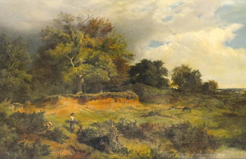
Sold2021Sidney Richard Percy ''Near Capel Curig, North Wales"Sidney Richard Percy (1821-1886 British) ''Near Capel Curig, North Wales'' 1851 Oil on Canvas 24''x36'' Image. A countryside composition with woman and men gathering and sheep in background. Signed anSee Sold Price
Sold2022HARVEY R. PETERSON (CONTEMPORARY NORTHPORT, MAINE)"Penobscot Man", a Sea Captain with Binoculars, carved and painted wood, clothed in old sea charts, having three compasses (one inset in his belly, one in his plinth and a small one in the drawer at tSee Sold Price
Sold20241st ed. of Moll’s fascinating 1701 map of Isle of CaliforniaHerman Moll's renowned and highly sought-after map showing California as an island, plus the western part of North America. This is the first appearance of this map, with page number 152 clearly shownSee Sold Price
Sold2022Britain.- Speed (John) England Wales and Scotland... from a farr Larger Voulume done by John Speed,British Isles.- Speed (John) England Wales and Scotland... from a farr Larger Voulume done by John Speed, engraved title, table of distances, and 63 uncoloured engraved maps by Pieter Van den Keere inSee Sold Price
Sold2021PATRICK COLLINS (IRISH, 1910/11-1994).Oil on board. Man with Cello. Signed lower right. From a Port Washington, NY collection. Dimensions: 23" high x 16" wideSee Sold Price
Sold2024TWO NAUTICAL CHARTSEast Coast of North America 1870, 47 inches by 33 inches. George W. Eldridge Chart of Kennebec River to Deer Isle, 1916, 35 inches by 59 inches. Together with blue print of the US Merrimack and an 183See Sold Price
Sold2022William Mellor (British, 1851-1931) Welsh Llyn, North WalesWilliam Mellor (British, 1851-1931) Welsh Llyn, North Wales signed 'William Mellor' (lower right) oil on canvas 50.8 x 76.2cm (20 x 30in). Footnotes: Provenance With Haynes FineSee Sold Price
Sold2018"Nantile Lake - North Wales" By Alfred de Breanski Sr.Signed Alfred de Breanski (British, 1852 - 1928) (lower right); inscribed Nantile Lake / N.Wales (on the reverse). oil on canvas. 19th Century. DIMENSIONS: 17 in.H x 22 in.W x 2 in.D (43 cmH x 56 cmWSee Sold Price
Sold2022LARGE ARCHITECTS PRINT / MAP / CHART CABINETFantastic very large Architectural draftsman/chart/map/print flat file - George III-Style mahogany with satinwood inlay, inset tooled leather top. 8 Drawer over 4 drawer. from the Audubon Gallery, KinSee Sold Price
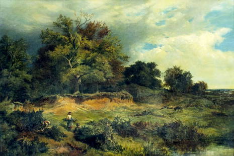
Sold2022Sidney Richard Percy (UK,1821-1886) oil painting antiqueARTIST: Sidney Richard Percy (British, 1821 - 1886) NAME: Landscape - Near Capel Curig, North Wales YEAR: 1851 MEDIUM: oil on canvas CONDITION: Minor stable craquelure. One small inpainting 1/4" x 1/2See Sold Price
Sold2022Bernard Cuzner Liberty & Co Sterling Cymric BowlBernard Cuzner (British, 1877-1956), a coworker of Archibald Knox (Manx (Isle of Man), 1864-1933) for Liberty & Co., Britain. "Cymric" style Art Nouveau sterling silver bowl with affixed opal stones,See Sold Price
Sold2023C. Zellner Portrait Oil on Canvas, 1905C. Zellner (Austrian, XIX-XX) oil painting on canvas depicting the portrait of a North African man, 1905, signed and dated upper right, housed in a gilt wood frame carved with Islamic design. Image: 1See Sold Price
Sold2023Hiroshi Sugimoto (Japanese, b. 1948)Hiroshi Sugimoto (Japanese, b. 1948), "Arctic Ocean, Nord Kapp", "North Sea, Berriedale" and "Ionian Sea, Santa Cesarea", 1990, 3 tri-toned offset lithographs mounted to original card, unsigned, eachSee Sold Price
2021ROLEX Sea-Dweller Men's Wristwatch in Stainless SteelThis Rolex Sea-Dweller Men's Wristwatch is entirely in Stainless Steel. This includes the round case, fluted bezel. solid engraved back, marked crown, lugs and oyster bracelet. The bezel is black painSee Sold Price
Sold2024Henry Bostwick, 1827, bound atlas "A Historical,Chronological and genealogical Chart" exhibiting maps of "Ancient Countries, as well as a new scale of time charts" developed by Bostwick including countries in the Mediterranean, Greece, France, andSee Sold Price
Sold20201761 MAP OF NORTH AMERICA BY ROCQUE18th century map GENERAL MAP OF NORTH AMERICA 1754-1761 by John Rocque, London by A. Drury, 2 part map, 35.5 x 36 inches, good condition.See Sold Price
Sold2016Map of North America...David H. Vance, engraved by J.H. Young. Philadelphia: Anthony Finley, 1825. Engraved map in 5 parts with original hand color in outline. 25 7/8 x 20 1/2 inches sheet, 30 5/8 x 25 1/2 inches framed.See Sold Price
May 12Hoch LTD.W. Taylor Oughton (American, 1925-2018) Romance Illustration Art, Man & Woman$20(1 bid)
5 days LeftHunt and Peck Estate Services, Inc.1822 George Thomson 6 vol. "Thomson's Collection of The Songs of Burns" Signed$400
May 16Freeman's | HindmanSir Jacob Epstein (British, 1880-1959) Tiger King (Man of Aran), conceived 1933$3,000
May 17Albion AuctionsGentleman's Magazine 1778 Canal Map. Belfast to Loughneagh Northern Ireland$5(1 bid)
May 17Albion AuctionsClarke & Russell 1814 Hand Col Map. Canada - British Dominions in North America$5(1 bid)
May 15University ArchivesScarce Early Printing: "An Account of the European Settlement in America in 6 Parts..."$100
May 18Alice Callahan Auction HouseLLADRO PORCELAIN FIGURINE "SEA OF LOVE" #6432 13"T 13"W 10" D$225(4 bids)


![Dudley Sea Chart of Denmark: DUDLEY, Sir Robert (1574-1649). [Denmark] Carta particolare che comincia con il gran fiume Albis e contene parte dell mare Baltico e Ientrata al sondo di Danemarca... Engraved map. Florence, 1646.20 7](https://p1.liveauctioneers.com/1968/250616/130196505_1_x.jpg?height=310&quality=70&version=1654190895)
![Dudley Sea Chart of Argentina: DUDLEY, Sir Robert (1574-1649). [Argentina] Carta particolare della costa di America Australe che comincia al C. di Matas sin al C. di Galegos. Engraved map. Florence, 1646. 20 7/8" x 16 1/8" sheet. S](https://p1.liveauctioneers.com/1968/250616/130196501_1_x.jpg?height=310&quality=70&version=1654190895)