Sold2018Johannes Kip After L. Knyff Antique Map of YorkJohannes Kip After Leonard Knyff (1650-1722) antique map of York. Measures 13.75" x 19" (plate size) and 18.75" x 22 3/8" (sheet size). Vg+-Ex/Ex condition. Unframed, loose and not mounted or glued doSee Sold Price
Sold2018Johannes Kip After L. Knyff Antique British MapJohannes Kip After Leonard Knyff (1650-1722) antique map. Measures 13.75" x 18.75" (plate size) and 18" x 22 7/8" (sheet size). Vg/Vg+ condition. Unframed, loose and not mounted or glued down. We shipSee Sold Price
Sold20213 antique maps, New York, North East United States3 maps, New York, North East, includes "Carte réduite des côtes orientales de l'Amérique septentrionale : contenant celles des provinces de New-York et de la Nouvelle Angleterre, celles de l'AcadieSee Sold Price
Sold2017Buache: Antique Map of New York, Long Island, 1807Map: Ile de New-York Partie de Long-Island ou de l'Ile Longue et positions des armées Américaine et Britannique après le combat livré sur les hauteurs, le 27 Août, 1776. Maker: Buache, Jean NicolSee Sold Price
Sold2023JAN KIP 18TH C ENGRAVING OF BADMINTON GLOUCESTERJohannes (Jan) Kip (Dutch 1653-1722). An 18th century hand colored copper engraving of "Badminton...", after Leonard Knyff, published 1724. Matted. From Kip's Johannes Kip’s monumental topographicalSee Sold Price
Sold2021Antique map, Northeast US, by Robert De VaugondyAntique map, Northeast US, by Robert De Vaugondy "Partie De L'Amerique Septentrionale Qui Comprend Le Cours De L'Ohio, La Nlle Angleterre, La Nlle York, Le New Jersey, La Pensyvanie, Le Maryland La ViSee Sold Price
Sold2022Antique French Map of AfricaAntique French Map of Africa. "Carte de L'Afrique..."by J. Andriveau-Goujon, Paris, dated 1841. Framed. Ex. Collection William and Diane Bousquette, Purchase, New York. Size: 15'' x 19.5'', 38 x 50 cmSee Sold Price
Sold2021Antique 18th C Jan Kip Hand Colored EtchingAntique 18th Century Johannes (Jan) Kip (Dutch, 1653 - 1722) Hand Colored Etching & Engraving Titled, "Badminton in the County of Gloucester". After Leonard Knyff. Circa 1714. Professionally framed anSee Sold Price
Sold2023A Decorative Pictorial Map of The New York Worlds Fair by William L. Longyear (American, 1899-1980)A Decorative Pictorial Map of The New York Worlds Fair by William L. Longyear (American, 1899-1980). Framed. Designed and copyrighted by William Longyear. Lithographed in U.S.A by Polygraphic CompanySee Sold Price
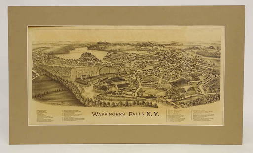
Sold2022Wappingers Falls New York Large ViewWappingers Falls, N.Y. Large Panorama Bird's-eye Map. L.R. Burleigh, Troy, New York, c. 1889. Antique print. 15" x 29".See Sold Price
Sold20231755 Robert De Vaugondy Map of North America Large1755 Robert De Vaugondy Map of America. Mid-Atlantic, New York, New Jersey, Pennsylvania Virginia, Maryland, New England, Carolina and Ohio. Partie De L'Amerique Septentrionale. Map in matte is aboutSee Sold Price
Sold2020Puzzle box with wood cubs with maps of the worlds atlasCartographical Cube toy 1889 Maison jullien (J L) Antique Map Charles VerneauAppealing cartographical toy, consisting of 20 wooden cubes, each side of each cube with a map section pasted on, thus formSee Sold Price
Sold2018Early Map Egypt Nubia AfricaDe l'Egipte. Antique map by Clouet, Paris, 1730. Egypt, Nubia, Abyssinia, Middle East, Asia. . 16" x 24.See Sold Price
Sold2017Antique Map: New York & Area - EngravingPensylvania Nova Jersey et Nova York cum Regionibus Ad Fluvium Delaware In America Sitis, Nova Delinatione ob oculos posita...Tobias Conrad Lotter (1717 - 1777). Engraved map with hand-color in part.See Sold Price
Sold2016Antique Map : New York, New Jersey - 1870Antique Map : New York, New Jersey, Pennsylvania, Ohio, Delaware, Maryland , Virginia & West Virginia - 1870 Size : 15.5" x 18.5"See Sold Price
Sold2021Lot Antique Maps New York New JerseyLot of Antique Maps Of New York, New Jersey & Massachusetts. Includes 11 maps from 19th century. Largest map measures 20 inches in height by 23 inches in width. This sale is online only - no public prSee Sold Price
Sold2023Weller, F. S. 1894 Antique Map. New York and EnvironsLithograph Map Published 1891-94 by Cassell & Co., London for "Cassell's Encyclopaedia A Storehouse of General Information" by Various Authors. Map by F. S. Weller. Folds as issued. Paper Size: 11 x 9See Sold Price
Sold2017Johnson: Antique Map of New York City, 1866Title/Content of Map: 1866 Johnson Map of New York City -- Johnson's New York and Brooklyn Date Printed: 1866, New York Cartographer: A Johnson Size: 22.8 x 16.3 in Condition: Very good. Age toning noSee Sold Price
Sold2018Mitchell: Antique Map of New York City, 1860Title/Content of Map: 1860 Mitchell Map of New York -- Plan of New York & c. Date Printed: 1860, Philadelphia Cartographer: S Mitchell Size: 13.5 x 10.5 in. An excellent map of lower Manhattan, EllisSee Sold Price
Sold2017Tanner: Antique Map of New York City, 1843Title/Content of Map: New York City by Tanner Date Printed: 1843 Cartographer: based on the work of H.C. Tanner Material/Medium: Paper Size: 17" x 14" Hand colored engraved Map. From the first editionSee Sold Price
2018Buchon: Antique Map of New York, 1825Title/Content of Map: 1825 Buchon Map of New York -- Carte Geographique, Statistique et Historique Du New-York Date Printed: 1825, Paris Cartographer: J A Buchon Size: 16 x 24 in. This quite attractivSee Sold Price
Sold2017Richmond: Antique Map of New York State Canals, 1858Title/Content of Map: 1858 Richmond map of the New York State Canals -- Map and Profiles of New-York State Canals Date Printed: 1858, Albany Cartographer: Van R Richmond Size: 22.8 x 39.8 in. A very iSee Sold Price
Sold2017Cowperthwait: Antique Map of New York, 1850Title: Map of New York by Cowperthwait Date: 1850 Medium: Hand Colored Lithograph Dimensions (in.): 14 x 17 No Reserve: This lot starts at $1 and has no reserve as a courtesy so that collectors can deSee Sold Price
Featured3 hrs LeftJasper52Solomon Wise Judgement - Original antique engraving after G Freman, 17th century.$65
1 day LeftJasper52Entrée de Norton & Détroit de Bhering. Bering Strait Norton Sound BONNE 1790 map$30(1 bid)
Featured1 day LeftJasper52Entrée de Norton & Détroit de Bhering. Bering Strait Norton Sound BONNE 1788 map$30
1 day LeftJasper52Océanique. Archipel des Nouvelle Hébrides #39. Vanuatu. VANDERMAELEN 1827 map$85
1 day LeftJasper52NEW CALEDONIA. Nouvelle Caledonie. Loyalty Islands/Îles Loyauté. Nouméa 1929 map$40
1 day LeftJasper52NEW CALEDONIA. Nouvelle Caledonie. Loyalty Islands/Îles Loyauté. Nouméa 1931 map$40
1 day LeftJasper52Océanique Partie… des Iles Basses 48 SE Tuamotus Polynesia VANDERMAELEN 1827 map$50
1 day LeftJasper52Océanique Partie… des Iles Basses 48 SE Tuamotus Polynesia VANDERMAELEN 1827 map$50