Sold2020Land Ho! Antique Fishers Island Sound, RI-CT-NY USCGDescription: Ahoy! Antique Coast Guard nautical chart of Fishers Island Sound, RI-CT-NY. Numbered C. & G. S. 358; published 1968. Material: paper. Measurement: approximate 36" x 45" (INCHES). ShippingSee Sold Price
Sold2019Land Ho! Antique Western L.I. Sound, CT U.S. CoastDescription: Ahoy! Antique Coast Guard nautical chart of the L.I. Sound. Numbered C. & G. S. 1213; printed in 1968. Material: paper. Measurement: approximate 34" x 40" (INCHES). Shipping cost: $10; diSee Sold Price
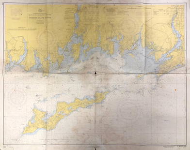
Sold2021Chart of the Connecticut River, CTChart of the Connecticut River, CT, U.S. Coast Guard nautical chart of the Connecticut River, CT. C. & G. S. 215; published 1968. Approximate measurements: 34" x 41" (INCHES). Materials: PaperShippingSee Sold Price
Sold2019Land Ho! Antique Narragansett Bay, RI and MA U.S. CoastDescription: Ahoy! Antique Coast Guard nautical chart of the Narragansett Bay. Numbered C. & G. S. 353; with corrections from the Coast Guard denoted in purple. Material: paper. Measurement: approximaSee Sold Price
Sold2019Land Ho! Antique Block Island Sound, RI USCGDescription: Ahoy! Antique U.S. Coast Guard nautical chart of Block Island Sound and Approaches. Numbered C. & G. S. 1211; published 1968. Material: paper. Measurement: approximate 36" x 41" (INCHES).See Sold Price
Sold2023Antique CT River Valley 2 part cupboard w shaped shelves & 2 glass doors over 2 cupboard doors - 77'Antique CT River Valley 2 part cupboard w shaped shelves & 2 glass doors over 2 cupboard doors - 77' tall x 50 1/2" wide x 17 1/4" deepSee Sold Price
Sold2017Ferrer: Antique Nautical Chart of Nassau River, 18091809 Nautical Chart of Nassau River and Part of Amelia Island and Talbot Island (Florida). Original engraving from José Joaquín de Ferrer y Cafranga's sea atlas, the 'Portulano de los Estados UnidosSee Sold Price
Sold2023Thomson, John (Pub) 1825 Antique Mountain & River Chart"View of some of the principal Rivers in the World" Copper Engraved Map Published 1825 by John Thomson, Edinburgh for "The Edinburgh School Atlas" by N. R. Hewitt. Maps Engraved by Hewitt. Original OuSee Sold Price
Sold2017Ferrer: Antique Nautical Chart of St. John River, 18091809 Nautical Chart of St. John River, Jacksonville, Florida. Original engraving from José Joaquín de Ferrer y Cafranga's sea atlas, the 'Portulano de los Estados Unidos', published in Madrid in 181See Sold Price
Sold2017Revolutionary War era chart of Delaware Bay and RiverTitle/Content of Map: Revolutionary War era chart of Delaware Bay and River Date Printed: 1779 Cartographer: Gentlemans Magazine Size (in): 9 x 7 Small antique chart of Delaware Bay and River. DerivedSee Sold Price
Sold2023CHART: United States East Cost Connecticut. / CONNECTICUT RIVER/ HIGGAUM TO ROCKY HILLDescription: CHART: United States East Cost Connecticut. / CONNECTICUT RIVER/ HIGGAUM TO ROCKY HILLMeasurement approximate: 26 x 39” InchesSee Sold Price
Sold2022Superb 1686 CT Colony Land DeedSuperb 1686 CT Colony Land Deed CONNECTICUT COLONY. Manuscript Document Signed, “Humphrey Pryor”, 1p on a bifold sheet, 11.75" x 7.5", Windsor, May 6, 1686. Docket of recording on the thirSee Sold Price
Sold2022George LePore (CT,1931-2013) acrylic paintingARTIST: George LePore (Connecticut, 1931 - 2013) NAME: Autumn Landscape, Bantam River, CT (titled on verso) MEDIUM: acrylic on board CONDITION: Very good. No visible inpaint under UV light. SIGHT SIZESee Sold Price
Sold2023EDWARD L. CUSTER CONNECTICUT RIVER SCHOOL OIL ON BOARDEDWARD L. CUSTER CONNECTICUT RIVER SCHOOL OIL ON ARTIST'S BOARD PAINTING. Height: 12 in. by Width: 19 in.See Sold Price
Sold2016G. Sandorff Antique Connecticut Oil Painting With CowsA paper label on the back of this circa 1890 canvas identifies the location as "Housatonic River Conn." The scene features cows in the foreground, a man and boy heading toward them from a red-roofed hSee Sold Price
Sold2017Upper CT River Valley country easy chairWonderful late 18th or early 19th c country Chippendale/Hepplewhite cherry upholstered open arm easy chair, probably Upper Connecticut River Valley.See Sold Price
Sold2016Delbert Gish, Am., Town Along CT River, o/cDelbert Gish, Am., 20th, Town along Connecticut River, Mt.Ascutney in background, o/c signed lower right Note: bears frame makers label House of Heydenryk, NYC(PFOS5107)(MM). Measurements: 26 x 40, frSee Sold Price
Sold2018Vancouver: Antique Chart of Northwest Coast of AmericaTitle/Content of Map: A Chart Shewing Part of the Coast of N.W. America, with the Tracks of His Majesty's Sloop Discovery and Armed Tender Chatham . . . [Columbia River to Northern California] Date PrSee Sold Price
Sold2022Kruseman Van Elten Etching Shepang River, CTKruseman Van Elten (Dutch, 1829-1904) Etching, "On The Shepang River, Connecticut." Signed and dated in plate. Etching measures 6.25 inches x 9.5 inches. Matting measures 14.75 inches x 17 inches.See Sold Price
Sold2023NAUTICAL CHART / CONNECTICUT/ NORTH SHORE OF LONG ISLAND GUILFORD HARBOR TO EAST HAVEN RIVERDescription: NAUTICAL CHART / CONNECTICUT/ NORTH SHORE OF LONG ISLAND GUILFORD HARBOR TO EAST HAVEN RIVER. Published at Washington D.C/ US Department of Commerce National Oceanic and Atmosphere AdminiSee Sold Price
Sold2023Antique LFC Cast Iron Coffee Grinder Original Red W Decals Landers Frary Clark New Britain CTAntique LFC cast iron coffee grinder original red with decals Landers Frary Clark New Britain CT Connecticut kitchen foodie manual appliance. With iconic OIL THE BALLS side instructions, 12in x 11in xSee Sold Price
Sold2016Group 31 Connecticut Land Deeds, 18th CenturyThirty-one Connecticut land deeds, 18th century, dated 1770-1787. Provenance: 23 from the Hull Family, Wallingford, CT. Largest: 12 1/2" high, 7 1/2" wide. Smallest: 8 1/4" high, 6 1/2" wide. ConditioSee Sold Price
Sold2021Lillian August CT Antique Pine Jelly / Pie CabinetLillian August Connecticut Antique Glass Front Plank Construction Pine Jelly Cabinet or Pie Cabinet or Side Board or Display Cabinet. 73 inches x 44 inches x 18 inchesSee Sold Price
Sold2023Babcock Printing Press (New London, CT) 2 PcsBabcock Printing Press (New London, Connecticut) Antique Advertising Glass Paperweights (2 different variations). Mixed condition. Provenance: Private collection Washington state, with the majority haSee Sold Price
7 days LeftJasper52South Namibia coast. Walvis Bay-Orange River ADMIRALTY sea chart 1881 (1954) map$85
2 days LeftClark's Auction CompanyWarren Jay Clear, Pei Ho River Fishing Scene, 1919, Watercolor on Paper$40
7 days LeftJasper52Western coast of Africa… to the River Sanaga. Southern Mauritania LABAT 1745 map$15
Jun 08Simpson Galleries, LLC.MATTHAUS SEUTTER (1678-1757) A MAP OF THE HOLY LAND AND TWELVE TRIBES, "Terra Sancta Vocatta Que$150
191 Lots AwayDawsons AuctioneersFrom the estate of Vivian Stanshall, founding member of the Bonzo Dog Doo-Dah Band, a collection of£320
Jun 13Bedford Art GalleryAntique Hudson River School, Landscape Oil Painting, 19th century, c.1800s$900


![Vancouver: Antique Chart of Northwest Coast of America: Title/Content of Map: A Chart Shewing Part of the Coast of N.W. America, with the Tracks of His Majesty's Sloop Discovery and Armed Tender Chatham . . . [Columbia River to Northern California] Date Pr](https://p1.liveauctioneers.com/5584/114563/58815189_1_x.jpg?height=310&quality=70&version=1514941693)


