Sold20231758 Map Chart of World TradewindsAn Accurate Chart of the World with the New Discoveries....Tradewinds.., by Thomas Kitchin, 1758. Large folding map, measures 17 x 13", Condition issues including creasing and repaired breaks at foldsSee Sold Price
Sold2024Thomas Jefferys - Map of Hungary with Turky in Europe [shows Cyprus]Hand-coloured decorative map of Hungary, Greece, Turkey, Cyprus, and the Gulf of Venice, showing provinces, towns, islands, rivers, etc. Thomas Jefferys (ca. 1719-1771) was a prolific map publisher, eSee Sold Price
Sold2017Coast of West Florida and Louisiana Map"Coast of West Florida and Louisiana", by Thomas Jefferys (English, 1719-1771) copperplate engraved map, with the New Orleans environs heightened with hand-colored gold, published London, 1775. MattedSee Sold Price
Sold20241794 Laurie & Whittle after Thomas Jefferys Map Of The United States Of AmericaWITH THE BRITISH POSSESSIONS OF CANADA, NOVA SCOTIA, NEW BRUNSWICK, AND NEWFOUNDLAND divided with the French, also The Spanish Territories Of Louisiana and Florida according to the Premliminary ArticlSee Sold Price
Sold2022(UNITED STATES.) Laurie & Whittle; after Thomas Jefferys. The United States of America(UNITED STATES.) Laurie & Whittle; after Thomas Jefferys. The United States of America with the British Possessions of Canada, Nova Scotia, New Brunswick and Newfoundland Divided with the French, alsoSee Sold Price
Sold2024Kinkade Signed AP New Day Dawning Art w/ COAA large thomas kinkade signed and numbered artist proof offset lithograph titled "A New Day Dawning" romance of the sea I. Framed in glass front gold frame. Hand signed and numbered 237/385 AP. IncludSee Sold Price
Sold2017AlbumsVery large collection of 33 albums: opera, jazz, New Orleans music including Irma Thomas, New Orleans The Living Legends, New Orleans Jazz FuneralsSee Sold Price
Sold2023Lot of Four Large Shell NecklaceFour large shell necklaces, Possibly Papuan Gulf; Gulf Province, Papua New Guinea. Each of cowrie shells sewn to fiber necklaces. Two pierced at the sides of the shells and attached with native fiber;See Sold Price
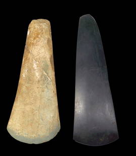
Sold2023A Pair of Stone Axe Heads from Papua New GuineaThis Lot contains two large and fine stone axe heads, Southern Highlands Province, Papua new Guinea. The two large stone blades that were used both as tools and as wealth, various colors of the stoneSee Sold Price
Sold2022FULLER, CAPTAIN WILLIAM; JEFFERYS, THOMAS; and DE BRAHM, WILLIAM GERARD Plan of Amelia Island inFULLER, CAPTAIN WILLIAM; JEFFERYS, THOMAS; and DE BRAHM, WILLIAM GERARD Plan of Amelia Island in East Florida [and] A Chart of the Entrance into St. Mary's River...[and] A Chart of the Mouth of NassauSee Sold Price
Sold2022JEFFERYS, THOMAS The Coast of West Florida and Louisiana/ The Peninsula and Gulf of Florida orJEFFERYS, THOMAS The Coast of West Florida and Louisiana/ The Peninsula and Gulf of Florida or Channel of Bahama with the Bahama Islands. London: Robert Sayer, 20 February 1775. Engraved map on joinedSee Sold Price
Sold2021Alan Thomas Negatives New York CentralFrom the Alan Thomas collection a large group of medium format & 35mm black & white negatives from the New York Central mostly eastern areas. This is a large group and dates vary from 1960s-1980s. ThiSee Sold Price
Sold2022Canada.- Jefferys (Thomas) An Exact Chart of the RiverCanada.- Jefferys (Thomas) An Exact Chart of the River St. Laurence, from Fort Frontenac to the Island of Anticosti Shewing the Soundings, Rocks, Shoals &c..., large-scale navigational chart of the StSee Sold Price
Sold2019[Ireland] Savage, John, Thomas Kelly, New York, 1878,[Ireland] Savage, John, Thomas Kelly, New York, 1878, Picturesque Ireland with 33 color maps and 29 engraved plates; large, thick quarto, contemporary three-quarter green morocco, bevelled boards, raiSee Sold Price
Sold2019West Indies.- Barbados.- Jefferys (Thomas) A Map of theWest Indies.- Barbados.- Jefferys (Thomas) A Map of the Island of Barbados, Drawn from an actual survey, and from the observations of Mr. Griffiths Hughes, large title cartouche in the upper right, enSee Sold Price
Sold2018Canada.- Jefferys (Thomas) An Exact Chart of the RiverCanada.- Jefferys (Thomas) An Exact Chart of the River St. Laurence, from Fort Frontenac to the Island of Anticosti Shewing the Soundings, Rocks, Shoals &c..., large-scale navigational chart of the StSee Sold Price
Sold2023A Large Telefolmin Shield, Star MountainsA Telefolmin shield, Oksapmin language group, Star Mountains, Sandaun Province, Papua New Guinea.Of classical form, the shield shallowly carved with linear and spiral designs punctuated with red and wSee Sold Price
Sold2023Large Kerewa Gope Board with FigureA Kerewa spirit board (Titi Ebiha), Kerewa people, Goaribari Island; Gulf province Papua New Guinea. (C. First half 20th Century)The board of classical style for the type, the figure with typical KereSee Sold Price
Sold2023A Fine and Large Kerewa Spirit BoardA fine and large Kerewa spirit board (Titi Ebiha), Kerewa people, Goaribari Island; Gulf province Papua New Guinea. (C. First half 20th Century)Of classical form the large board with a typical KerewaSee Sold Price
Sold2023Large Dramatic Wapo / Era Spirit BoardA fine Wapo /Era region spirit board (Gope); Gulf province Papua New Guinea. (C. 20th Century). Of interesting form, the well-carved board with face at top with radiating designs emerging from the topSee Sold Price
Sold2023A Large Wapo / Era Gope BoardA fine Wapo /Era region spirit board (Gope); Gulf province Papua New Guinea. (C. 20th Century).This fine and extremely large board with stylized head at the top, possibly of a turtle, the body made-upSee Sold Price
Sold2016MAP OF NEW YORK, THOMAS KITCHIN, 1756A MAP OF THE EASTERN PART OF THE PROVINCE OF NEW YORK, WITH PART OF NEW JERSEY, showing Pennsylvania, New York state, Long Island, Connecticut and New Hampshire, with Lake OntarioSee Sold Price
Sold2015THOMAS DONGANTHOMAS DONGAN (1634 - 1715) Royalist military officer during the English Civil War, Governor of the Province of New York. He is noted for having called the first representative legislature in New YorkSee Sold Price
Sold2017Map of the Province of New York in 1779Chorographical Map of the Province of New York in 1779. SAUTHIER & PEASE 1849 Size: Approx 96.0 x 72.5cm, 37.75 x 28.5 inches (Large); Please note that this is a folding map. Please note that this lotSee Sold Price
244 Lots AwayMynt AuctionsMichael Thomas Autographed Black Pro Style Jersey- Beckett W *BlackSee Sold Price
3 days LeftMynt AuctionsSaints Derek Carr & Michael Thomas Signed Full Size Speed Proline Helmet BAS Wit$10
4 days LeftMynt AuctionsSaints Michael Thomas Signed Lunar Full Size Speed Proline Helmet BAS Witnessed$10
Jun 07Freeman's | HindmanHARDY, Thomas. A large group of several sets in 161 volumes of Hardy's Works.$150
Jun 06Freeman's | HindmanCLEMENS, Samuel L. ("Mark Twain") (1835-1910). Adventures of Huckleberry Finn. New York: The Limited$200
3 days LeftLocati, LLCPortrait of a Young Boy and Dog, Oil on Canvas, American or English School$1,000(1 bid)
5 days LeftDoyle New YorkCased Victorian Sterling Silver Mounted Glass Dresser Set Silver marked Thomas Diller, London,$500
3 days LeftLocati, LLCBroderie Perse Chintz Applique Quilt, Probably New Jersey, Circa 1835$2,100(2 bids)


![Thomas Jefferys - Map of Hungary with Turky in Europe [shows Cyprus]: Hand-coloured decorative map of Hungary, Greece, Turkey, Cyprus, and the Gulf of Venice, showing provinces, towns, islands, rivers, etc. Thomas Jefferys (ca. 1719-1771) was a prolific map publisher, e](https://p1.liveauctioneers.com/8353/325198/175261422_1_x.jpg?height=310&quality=70&version=1712598926)


![FULLER, CAPTAIN WILLIAM; JEFFERYS, THOMAS; and DE BRAHM, WILLIAM GERARD Plan of Amelia Island in: FULLER, CAPTAIN WILLIAM; JEFFERYS, THOMAS; and DE BRAHM, WILLIAM GERARD Plan of Amelia Island in East Florida [and] A Chart of the Entrance into St. Mary's River...[and] A Chart of the Mouth of Nassau](https://p1.liveauctioneers.com/292/250642/130213561_1_x.jpg?height=310&quality=70&version=1654271664)


![[Ireland] Savage, John, Thomas Kelly, New York, 1878,: [Ireland] Savage, John, Thomas Kelly, New York, 1878, Picturesque Ireland with 33 color maps and 29 engraved plates; large, thick quarto, contemporary three-quarter green morocco, bevelled boards, rai](https://p1.liveauctioneers.com/197/143669/72658568_1_x.jpg?height=310&quality=70&version=1559851603)