Sold2016MAP OF NEW YORK, THOMAS KITCHIN, 1756A MAP OF THE EASTERN PART OF THE PROVINCE OF NEW YORK, WITH PART OF NEW JERSEY, showing Pennsylvania, New York state, Long Island, Connecticut and New Hampshire, with Lake OntarioSee Sold Price
Sold20221778 Map of South New York by Thomas Kitchin1778 Map of South New York by Thomas Kitchin Frame: 11.5" x 14" Map: 7.5" x 10" Thomas Kitchin(wiki)Thomas Kitchin (1718-1784) was an English engraver and cartographer, who became hydrographer to theSee Sold Price
Sold20231758 Folding Map of New England and Nova ScotiaA Map of New England and Nova Scotia with part of New York, Canada, and New Britain and the adjacent Islands of New Found Land and Cae Breton, by Thomas Kitchin, printed at London for London Magazine,See Sold Price
Sold2022[MAP-CUBA] KITCHIN, THOMAS. Plan of the Havana and its Environs, with the several posts and attacks[MAP-CUBA] KITCHIN, THOMAS. Plan of the Havana and its Environs, with the several posts and attacks made by the British Forces; under the command of the Earl of Albemarle and Sr. Geo. Pocock, which waSee Sold Price
Sold2022Early map, province of New York, with parts of New Jersey dated 1756, printed for R. Baldwin inEarly map, province of New York, with parts of New Jersey dated 1756, printed for R. Baldwin in Pater Noster, drawn from the best authorities by T. Kitchin, map is 7.25" by 9" (sight)See Sold Price
Sold2020KITCHIN, THOMAS. A New Map of the British Empire inKITCHIN, THOMAS. A New Map of the British Empire in Nth. America. Hand-colored engraved folding map of colonial North America from George Millar's New and Universal System of Geography. 13½x15See Sold Price
Sold2016Thomas Kitchin - A New Map Of Italy With The Islands OfThomas Kitchin - A New Map Of Italy With The Islands Of Sicily, Sardinia & Corsica, 1790 Size: 31 X 36 In. - This Is A Gallery Stretched Giclee Print On Canvas. The Piece Was Printed On High Quality ASee Sold Price
Sold20231756 Thomas Kitchin Pennsylvania Map1756 British map titled "A Map of the Province of Pennsylvania", French & Indian War era engraved map of the Province of Pennsylvania by Thomas Kitchin printed for R. Baldwin appearing in the DecemberSee Sold Price
Sold20231756 Thomas Kitchin Pennsylvania Map Hand Colored1756 Thomas Kitchin A Map of the Province of Pennsilvania. French & Indian War era engraved map from London Magazine December 1756. 7 x 9 inches in matt.See Sold Price
Sold2019Thomas Kitchin (1718-1774), "A New Map of the UnitedThomas Kitchin (1718-1774), "A New Map of the United States of N. America," c. 1782, H. - 14 5/8 in., W. - 18 1/4 in.See Sold Price
Sold2022Oxford & Eastern counties.- Kitchin (Thomas) A newNO RESERVE Oxford & Eastern counties.- Kitchin (Thomas) A new Improved Map of Oxfordshire from the best surveys and intelligences, divided into hundreds, county map with decorative title cartouche inSee Sold Price
Sold20241850 Thomas, Cowperthwait & Co. Map of New York -- City of New-YorkTitle: 1850 Thomas, Cowperthwait & Co. Map of New York -- City of New-York Cartographer: Thomas, Cowperthwait & Co. Year / Place: 1850. Philadelphia Map Dimension (in.): 15.5 X 12. 4 in. This is map oSee Sold Price
Sold2018Thomas, Cowpwerthwait: Antique Map of New York, 1854Title/Content of Map: 1854 Thomas, Cowpwerthwait Map of New York State -- Map of the State of New York Compiled from the Latest Authorities Date Printed: 1854 Philadelphia Cartographer: Thomas, CowperSee Sold Price
Sold2015A Fine & Rare Map of New York.Bernard Ratzer "Plan of the City of New York". Signed lower right in the plate "T. Kitchin Sculpt" (Kitchin recorded the cartographer's name as Ratzen (sic) rather than Ratzer). The map backed, rolledSee Sold Price
Sold2019Kitchin, Thomas 1758 Map of England and Wales"A New Map of England and Wales" Copper Engraved Map Published 1758, London for "A Complete History of England…" by Thomas Smollett. Map by Thomas Kitchin (Kitchen) Folds as issued. Paper Size: 20 xSee Sold Price
Sold20241894 Old New York, Janvier, IllustratedHardcover copy of In Old New York by Thomas A. Janvier. Published by Harper and Brothers, 1894. Contains illustrations and maps. Wear to cover, pages, and spine consistent with exposure. Binding is loSee Sold Price
Sold20231758 Map Chart of World TradewindsAn Accurate Chart of the World with the New Discoveries....Tradewinds.., by Thomas Kitchin, 1758. Large folding map, measures 17 x 13", Condition issues including creasing and repaired breaks at foldsSee Sold Price
Sold2016THOMAS KITCHIN (ENGLAND 1718-1784), "A NEW AND ACCURATETHOMAS KITCHIN (ENGLAND 1718-1784), "A NEW AND ACCURATE MAP OF THE BRITISH DOMINIONS IN AMERICA, ACCORDING TO THE TREATY OF 1763; DIVIDED INTO THE SEVERAL PROVINCES AND JURISDICTIONS", C.1765. SIGHT 2See Sold Price
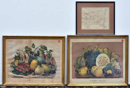
Sold2020Two Currier & Ives PrintsAutumn Fruits and Summer Fruits each 15 1/2" x 19" stone lithographs and a Map of the State of New York by J. Denison, published by Thomas & Andrews, Boston, 1796See Sold Price
Sold2016THOMAS KITCHIN (ENGLISH 1718-1784) ENGRAVED MAP OFTHOMAS KITCHIN (ENGLISH 1718-1784) ENGRAVED MAP OF MEXICO AND NEW SPAIN FROM ROBERTSON HISTORY OF AMERICA 1778. SIGHT 11 X 14 3/4"; FRAMED AND GLAZED 16 1/2 X 20 1/4"See Sold Price
Sold2019[Ireland] Savage, John, Thomas Kelly, New York, 1878,[Ireland] Savage, John, Thomas Kelly, New York, 1878, Picturesque Ireland with 33 color maps and 29 engraved plates; large, thick quarto, contemporary three-quarter green morocco, bevelled boards, raiSee Sold Price
Sold2017Thomas Kitchin, Maryland and Scotland maps(Scottish, 1718-1784)., "Map of Maryland with the Delaware counties and the southern part of New Jersey," hand colored map, circa 1750, 7 x 9 in. , framed and "Scotland," circa 1760, 7 1/2 x 9 in. , fSee Sold Price
Sold2021Guthrie, William 1790 Map. Turkey in Europe & HungaryCopper Engraved Map Published 1790, London for "A New Geographical, Historical and Commercial Grammar..." by William Guthrie. The maps are by John Senex, Thomas Kitchin and others. Folds as issued. EaSee Sold Price
Sold2021Guthrie, William 1806 Map. World HemispheresCopper Engraved Map Published 1806, London for "A New Geographical, Historical and Commercial Grammar..." by William Guthrie. The maps are by John Senex, Thomas Kitchin and others. Folds as issued. PaSee Sold Price
May 16Potter & Potter Auctions[NEW YORK CITY – PICTORIAL MAPS]. Group of 3 pictorial maps...$200(1 bid)
3 days LeftEldred'sTHOMAS CAIN (New York, 1956-), Abstract with a crescent, circle, stars and other shapes., Mixed$100
11 hrs LeftTremont AuctionsJohn Speed and Francis Lamb "Map of New England and New York", ca. 1676. Hand colored engraved map$900(3 bids)


![[MAP-CUBA] KITCHIN, THOMAS. Plan of the Havana and its Environs, with the several posts and attacks: [MAP-CUBA] KITCHIN, THOMAS. Plan of the Havana and its Environs, with the several posts and attacks made by the British Forces; under the command of the Earl of Albemarle and Sr. Geo. Pocock, which wa](https://p1.liveauctioneers.com/292/250642/130213656_1_x.jpg?height=310&quality=70&version=1654271664)


![[Ireland] Savage, John, Thomas Kelly, New York, 1878,: [Ireland] Savage, John, Thomas Kelly, New York, 1878, Picturesque Ireland with 33 color maps and 29 engraved plates; large, thick quarto, contemporary three-quarter green morocco, bevelled boards, rai](https://p1.liveauctioneers.com/197/143669/72658568_1_x.jpg?height=310&quality=70&version=1559851603)


![[ROBERTSON, William C., engraver]. The Battle of Gettysburg... (1 of 1)](https://p1.liveauctioneers.com/928/328184/176813692_1_x.jpg?height=282&quality=70&version=1714496988)

![[KELLY, Thomas (1809-1871), printer]. The Grand Army of the... (1 of 1)](https://p1.liveauctioneers.com/928/328184/176813665_1_x.jpg?height=282&quality=70&version=1714496988)
![[George Washington] 1863, New York, Crowell (1 of 4)](https://p1.liveauctioneers.com/5755/327684/176532863_1_x.jpg?height=282&quality=70&version=1714078974)


![[NEW YORK CITY – PICTORIAL MAPS]. Group of 3 pictorial maps... (1 of 3)](https://p1.liveauctioneers.com/928/325952/175495562_1_x.jpg?height=282&quality=70&version=1712935174)


