Sold2020"Apocryphal" Lewis and Clark with Map, 1809"Apocryphal" account of Lewis and Clark 1809, with fold-out map. Title pages states 5 engravings. The book contains 4 engravings that we believe are original to the book: Sioux Queen (facing title pagSee Sold Price
Sold2021Map of North and South CarolinaMap is North and South Carolina by H. S. Tanner North and South Carolina 1825 printed in 1967 by Lewis and Clark explorer maps LTD Kitty Hawk North Carolina re-printed from the original map publishedSee Sold Price
Sold2017Oregon Historical Society Lewis & Clark Trail Map1986 Oregon Historical Society Lewis & Clark Trail 1804-1806 Map, depicts illustrated trail points from Missouri to Oregon, measures 32'' x 18'', printed in the U.S.A.See Sold Price
Sold2022Early American Map Lewis Clark Major Long US Missouri Arkansas TerritoryTitle: Early American Map Lewis Clark Major Long US Missouri Arkansas Territory Description:Early American Map Lewis Clark Major Long US Missouri Arkansas Territory With some hand coloring. Early GarlSee Sold Price
Sold2017Lewis and Clark 1803-1806 mapDavid Maydole Matteson. Lewis and Clark 1803- 1806. Drawn by David Maydole Matteson Route of Lewis and Clark to Oregon and return 1803- 1806. Framed. Medium: Print. Size: 6.5" X 8.5". Signature: UnsigSee Sold Price
Sold2020JOHN SPEED COPPERPLATE MAP RADNOR, C1610Original copperplate map with later coloring. Unexamined out of frame. Dimensions: (Frame) H 19” x W 24” (Sight) H 15.25” x W 20” Condition: Map with center fold. Slight toning. Condition:See Sold Price
Sold2017Thomas & Andrews: Antique Map of Massachusetts, 1796Map: Massachusetts Date: 1796 Medium: Original copperplate engraving From Morse's Universal Geography by Thomas & Andrews, Boston, 1796 Dimensions: 15" x 12.5" Unframed. Please note that this lot hasSee Sold Price
Sold20201848 America Scenes Native American Indians MAP Lewis1848 America Scenes Native American Indians MAP Lewis Clark Columbus Cortes ‘Scenes in America’ is a highly desirable illustrated 19th-century book on the development of America. Written by IsaacSee Sold Price
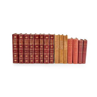
Sold2023Lewis, Meriwether and William Clark Original Journals of the Lewis and Clark Expedition 1804-1806Lewis, Meriwether and William Clark Original Journals of the Lewis and Clark Expedition 1804-1806 Edited, with Introduction, Notes, and Index, by Reuben Gold Thwaites. New York: Dodd, Mead & Company,See Sold Price
Sold20162004-P LEWIS & CLARK UNC SILVER DOLLAR ORIGINAL US MINTORIGINAL US MINT PACKAGINGSee Sold Price
Sold20152004-P LEWIS & CLARK UNC SILVER DOLLAR ORIGINAL US MINTORIGINAL US MINT PACKAGINGSee Sold Price
Sold20162004-P LEWIS & CLARK UNC SILVER DOLLAR ORIGINAL US MINTORIGINAL US MINT PACKAGINGSee Sold Price
Sold2021Odyssey Toys Lewis & Clark Figures - New in OriginalOdyssey Toys Lewis & Clark Figures - New in Original BoxSee Sold Price
Sold20152004-P LEWIS & CLARK SILVER DOLLAR UNC ORIGINAL US MINTORIGINAL US MINT PACKAGINGSee Sold Price
Sold2016E H Spencer Northumberland & Durham, original posterE H Spencer Northumberland & Durham, original poster printed for BR(NER) by Nathaniel Lloyd 1960 - 102 x 127 cm; Estra Clark A Map of Yorkshire, original poster printed for RE(E&NER) by Waterlow 1949See Sold Price
Sold2017Moll: Map of Poland, 1701Map of Poland. An original copperplate engraving published by Herman Moll in 1701. With text describing the Kingdom Of Poland. 7 x 7.5 " (map only) Please note that this lot has a reserve. When you leSee Sold Price
Sold20181983 1st ed MASSIVE Atlas of Lewis & Clark Expedition J1983 1st ed MASSIVE Atlas of Lewis & Clark Expedition Journal Indians MAPS An enormous first edition printing of the ‘Atlas of the Lewis & Clark Expedition’ edited by Gary Moulton. This huge tomeSee Sold Price
Sold2022Virginia, Marylandia, et CarolinaTitle: Virginia, Marylandia, et Carolina Date Printed: 1714 Cartographer: Homann, J.B. Material/Medium: atlas map, copperplate engraving, original hand color Size: 19.5 x 23 Condition: The map has oveSee Sold Price
Sold2021Lewis and Clark Journals 1962 Limited Ed. ClubLewis and Clark Journals 1962 with maps. This is a two volume set with slipcase. The Limited Editions Club New York. Numbered '757' of 1500. 772 pp. Many color illustrations. Pictorial map covers. ExSee Sold Price
Sold20231782 COPPERPLATE ENGRAVED MAP OF EUROPEOriginal antique copperplate engraved map of “Europe” engraved for Baldwins New Complete and Universal System of Geography. Published by Thomas Conder circa 1782.Professionally framed andSee Sold Price
Sold2023General Chart on Mercators Projection. World. Cook's route. PAYNE 1798 old mapTITLE/CONTENT OF MAP: 'General Chart on Mercators Projection' DATE PRINTED: 1798 IMAGE SIZE: Approx 18.0 x 25.0cm, 7 x 9.75 inches (Medium) TYPE: Antique copperplate engraved map with original hand coSee Sold Price
22 hrs LeftJasper52ASIA ANCIENT Middle East India Arabia Scythia Serica Parthia ARROWSMITH 1828 map$25
22 hrs LeftJasper52La Tartaria Indipendente… Central Asia, Caspian Sea & Caucasus. ZATTA 1785 map$100(1 bid)
Jun 07Freeman's | Hindman[MAP]. SARTINE, Antoine Plan de la Barre et du Havre de Charles-Town...1778. RARE REVOLUTIONARY WAR$1,000(1 bid)
Jun 07Freeman's | Hindman[LEWIS & CLARK EXPEDITION]. The Journal of the Lewis & Clark Expedition. Gary E. Moulton, editor.$300
2 days LeftKinghams AuctioneersTolkien, J.R.R. 'The Hobbit, or There and Back Again', 1st ed, 1st impression, pub Allen & Unwin,£3,400
1818 AuctioneersIllustrated. John Hassall. The Humours of Bridge by Cumberland Clark. London: Printed by Wass,£5


![[MAP]. SARTINE, Antoine Plan de la Barre et du Havre de Charles-Town...1778. RARE REVOLUTIONARY WAR (1 of 1)](https://p1.liveauctioneers.com/197/329395/177650540_1_x.jpg?height=282&quality=70&version=1715364962)
![[LEWIS & CLARK EXPEDITION]. The Journal of the Lewis & Clark Expedition. Gary E. Moulton, editor. (1 of 1)](https://p1.liveauctioneers.com/197/329395/177650557_1_x.jpg?height=282&quality=70&version=1715364962)


