Sold20231782 COPPERPLATE ENGRAVED MAP OF EUROPEOriginal antique copperplate engraved map of “Europe” engraved for Baldwins New Complete and Universal System of Geography. Published by Thomas Conder circa 1782.Professionally framed andSee Sold Price
Sold2024Turkey in Europe Hungary. Balkans. PAYNE 1798 old antique map plan chartTITLE/CONTENT OF MAP: 'Turkey in Europe and Hungary' DATE PRINTED: 1798 IMAGE SIZE: Approx 18.5 x 22.0cm, 7.25 x 8.75 inches (Medium) TYPE: Antique copperplate engraved map with original hand colourinSee Sold Price
Sold2017Homann Heirs: Antique Map of Europe, 1746Map: Europe ** Nuremberg?? Date Printed: 1746 Cartographer: Homann Heirs Material/Medium: Paper Size: 21" x 23 1/4" Nuremberg. Hand colored copperplate engraved. Beautiful baroque style cartouche. PleSee Sold Price
Sold2018Seutter: Antique Map of Europe, 1740Title/Content of Map: Europe by Seutter Date Printed: c1740 Cartographer: Matthaus Seutter Material/Medium: Paper Size: 19" x 23" Original hand colored copperplate engraved. Published in Augsburg. PubSee Sold Price
Sold2018Trio of 16th C. European Engraved Maps**Originally Listed At $250** Europe, ca. 16th century CE. A trio of copperplate engraved maps of European places, with some text, all on leaves/pages taken from books. Size of each page: 7.65" W x 11See Sold Price
Sold2017Stackhouse: Antique Map of Europe, 1783Title/Content of Map: Europe Date Printed: 1783 Cartographer: Thomas Stackhouse Material/Medium: Paper Size: 16" x 20" Condition: Excellent Original hand color. Copperplate engraved. Published in LondSee Sold Price
Sold2017Stackhouse: Antique Map of Russia in Europe, 1783Title/Content of Map: Russia in Europe Date Printed: 1783 Cartographer: Thomas Stackhouse Material/Medium: Paper Size: 16" x 20" Original hand color. Copperplate engraved. Published in 'An Universal ASee Sold Price
Sold2022Guthrie & Kitchin 1782 Map. Europe ContinentCopper Engraved Map Published 1782, London for "A New Geographical, Historical and Commercial Grammar..." by William Guthrie. The maps are by John Senex, Thomas Kitchin and others. Folds as issued. PaSee Sold Price
Sold2022Guthrie & Kitchin 1782 Map. Russia or Moscovy in EuropeCopper Engraved Map Published 1782, London for "A New Geographical, Historical and Commercial Grammar..." by William Guthrie. The maps are by John Senex, Thomas Kitchin and others. Folds as issued. PaSee Sold Price
Sold2022Guthrie & Kitchin 1782 Map. Turkey in Europe & HungaryCopper Engraved Map Published 1782, London for "A New Geographical, Historical and Commercial Grammar..." by William Guthrie. The maps are by John Senex, Thomas Kitchin and others. Folds as issued. PaSee Sold Price
Sold2021Framed 17th C. German Engraved Map of France**First Time At Auction** Europe, German, 17th century. "Das Konigreich Franckreich" (The Kingdom of France) Nova Gallia Tabula - copper plate engraving, ca. 1630. A finely engraved map of the KingdomSee Sold Price
Sold2019EuropeTitle/Content of Map: Europe Date: 1598/99 Cartographer: Ruscelli Size: 11x9” Provenance: Venice Additional Info: Copperplate engraved. Reserve: $95.00 Shipping: Domestic: Free shipping to anywhereSee Sold Price
Sold20211842 Map of RussiaAuthor: Scott Title: 1842 Map of Russia Medium: Ink on Paper Dimensions: 9"X11.5" Map of Russia in Europe dated 1842. Engraved by R. Scott. Part of the New General Atlas of the World. Copper plate engSee Sold Price
Sold2016The Kingdom of ChinaJohn Speed (1552-1629). Copperplate Engraved Map. Abraham Goos & John Speed: 1627. 17 1/4 x 21 1/2 inches. This superb map of China, Korea and Japan is the only carte-a-figures map made of the region.See Sold Price
Sold2018Scarce Large 1634 Map of Americas by M. MerianRare Large Copperplate Engraved Map of the Americas Entitled "America Nouiter Delineata" by Matthäeus Merian (1593-1650) | | Title: America nouiter delineata Title (alt.): America noviter delineata |See Sold Price
Sold2017Coast of West Florida and Louisiana Map"Coast of West Florida and Louisiana", by Thomas Jefferys (English, 1719-1771) copperplate engraved map, with the New Orleans environs heightened with hand-colored gold, published London, 1775. MattedSee Sold Price
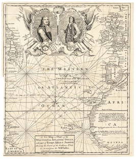
Sold20171740 Ornate Copperplate Engraved Portrait MapHistoric Maps 1740 Ornate Copperplate Engraved Map with Portraits of British Admirals “Robert Blake” & “Edward Vernon, Esq.” 1740-Dated, Copperplate Engraved Map titled “A New Map or Chart oSee Sold Price
Sold2020John Senex Map of North and South America 1719-17John Senex (1678–1740), "A New Map of America from the Latest Observations," London, ca. 1719-1721. Hand colored copperplate engraved map of North and South America, from Senex's "New General ASee Sold Price
Sold2020Angliae Scotiae et Hiberniae 1572 MapThe British Isles by Abraham Ortelius. The hand tinted copperplate engraved map has been nicely framed and with a reverse painted glass perimeter. Some slight discoloration consistent with age. OveralSee Sold Price
Sold20221849 Map of Austrian Dominions, A & C BlackNice example of Adam and Charles Black’s 1849 copperplate engraved map of the Austrian Empire. Covers an area once covered by Austrian control. Includes all or part of the modern nations of AusSee Sold Price
Sold2021Uncommon map of Texas – Mitchell/Butler 1868Title: Uncommon map of Texas – Mitchell/Butler 1868 Description: "Copperplate engraved map from Mitchell’s New Reference Atlas, a somewhat elusive school geography. Published by E. H. Butler in 18See Sold Price
Sold20201786 map of N. America by de la PorteScarce and beautiful double-page early copperplate-engraved map of North America depicting the new country right after America claimed her independence. Early east coast states delineated along with pSee Sold Price
Sold2017Important early map of St. Johns Island by T. JefferysA Map of the Island of St. John in the Gulf of St. Laurence...Thomas Jefferys (c. 1719 – 1771). Copperplate engraved map with handcolor in outline. London: Sayer & Bennett, 1775. 21 1/2 x 29 inchesSee Sold Price
Sold202218th C. MAPS OF NORTH AMERICA & CARIBBEAN (2 MAPS)Includes: Brian de la Tour, Louis. L'AMERIQUE DRESSEE POUR L'ETUDE DE LA GEOGRAPHIE (Paris, 1764).Copperplate engraved map of North and South America. Hand colored. Matted and framed. H. 11", W. 12" BSee Sold Price
May 08Jasper52Les Isles de la Guadeloupe, de Marie Galante… Îles des Saintes. BONNE 1780 map$45
May 08Jasper52Carte de l'Isle de la Martinique, Colonie Françoise…. Antilles. BONNE 1780 map$55


![[COLOR PLATE BOOK]. MUDFORD, William (1782-1848). An Histor... (1 of 5)](https://p1.liveauctioneers.com/928/328184/176813588_1_x.jpg?height=282&quality=70&version=1714496988)