Sold2018London Magazine: Antique Map of Havana, Cuba, 1762Title/Content of Map: A Plan of the City and Harbor of Havanna Capital of the Island of Cuba Cartographer: London Magazine Place & Date: London / 1762 Size: 4 1/2" x 7" Condition: wash color; overallSee Sold Price
Sold20231762 Magazine Plan of Havana Map of PortugalThe August 1762 issue of "Gentleman's Magazine" by Sylvanus Urban, printed at London, 48 pages and includes two engravings: A Plan of the City and Harbour of Havana and a large folding map of the KingSee Sold Price
Sold2022A Plan of the Siege of the Havana… Cuba. Gentleman's Magazine 1762 old mapTITLE/CONTENT OF MAP: 'A Plan of the Siege of the Havana Drawn by an Officer on the Spot 1762' DATE PRINTED: 1762 IMAGE SIZE: Approx 19.0 x 26.0cm, 7.5 x 10.25 inches (Medium); Please note that this iSee Sold Price
Sold2017Jefferys: Antique Plan of Puerto Cabanas, Cuba, 1762Map: Plan of Puerto de Cavanas Cartographer: Jefferys Place & Date: London / 1762 Size: 8" x 10 " Condition: outline color; overall age toning and minor spotting,mostly in margins A detailed plan of tSee Sold Price
Sold2017Anonymous: Antique Map Plan of Havana, 1766Title/Content of Map: A Plan of the Siege of the Havana, drawn by an Officer on the Spot, 1762 Date Printed: 1766 Cartographer: Anonymous Size (inches): 11 x 7 Antique map or plan of Havana, Cuba. ThiSee Sold Price
Sold20201762 Gibson map of Havana Cuba -- A Correct Plan of theTitle/Content of Map: 1762 Gibson map of Havana Cuba -- A Correct Plan of the City and Harbour of Havana Cartographer: J Gibson Year/Place: 1762, london Size: 7.1 X 9.4 in. This is a rather rare and dSee Sold Price
Sold2024Antique Map of New OrleansAntique Map of New Orleans, "Plan of New Orleans the Capital of Louisiana", 1761, by Benning, engraved map from the London Magazine, 7 1/2 in. x 9 1/2 in., framed.See Sold Price
2022Havana. Cuba 1885 old antique vintage map plan chartTITLE/CONTENT OF MAP: 'Havana' DATE PRINTED: 1885 IMAGE SIZE: Approx 22.5 x 29.0cm, 8.75 x 11.25 inches (Large); Please note that this is a folding map. TYPE: Antique colour map; Scale 1:14,000 CONDITSee Sold Price
Sold2021India 1747 Antique Map Plan of Fort St. George & Madras"A Plan of Fort St. George and the City of Madras" Copper Engraved Map Published 1732-85, London for "The London Magazine" Paper Size: 8 x 5 inch (20 x 13cm) Very minor toning. Good ConditionSee Sold Price
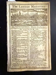
Sold20221762 London Magazine Attack on Havana and St. JohnsTitle: 1762 London Magazine Attack on Havana and St. Johns Description: The October 1762 issue of "The London Magazine", printed for R. Baldwin, 56 pages. Great content on military assault on Havana,See Sold Price
2022George Keppel, 3rd Earl of Albemarle. 1762 Capture of Havana, Cuba 1762 printTITLE/CONTENT OF MAP: [Portrait of] The Right Hon.ble George Earl of Albemarle Lieutenant General and Commander in Chief of the Land Forces, at the Conquest of the Havannah DATE PRINTED: 1762 IMAGE SISee Sold Price
Sold2020Italy 1747 Antique Map. View of Genoa, Ships"A View of the City of Genoa" Copper Plate Published 1732-85, London for "The London Magazine" Folds as issued. Paper Size: 11.5 x 8 inch (29 x 20cm) Good ConditionSee Sold Price
Sold2020India 1747 Antique Map Plan of Fort St. George & Madras"A Plan of Fort St. George and the City of Madras" Copper Engraved Map Published 1732-85, London for "The London Magazine" Paper Size: 8 x 5 inch (20 x 13cm) Very minor toning. Good ConditionSee Sold Price
Sold2020Netherlands 1747 Antique Map. Bergen-Op-Zoom"A New and Exact Plan of the Town and Fortifications of Bergen-Op-Zoom" Copper Engraved Map Published 1732-85, London for "The London Magazine" Folds as issued. Paper Size: 10.5 x 8 inch (27 x 20cm) GSee Sold Price
Sold2017Bowen: Antique Map of Cuba / Hispaniola, 1747Map: A New & Accurate Map of Cuba/A New & Accurate Map of Hispaniola or St. Domingo and Porto Rico Cartographer: Bowen Place & Date: London / 1747 Size: 16 1/2" x 13 3/4" Condition: b&w; overall age tSee Sold Price
Sold2023Universal Magazine 1748 Antique Map. Derbyshire UKCopper Plate Published London 1747-1815 for "The Universal Magazine of Knowledge and Pleasure" by Various. Folds as issued. Paper Size: 10 x 8.5 inch (26 x 22cm) Good ConditionSee Sold Price
Sold2023Universal Magazine 1748 Antique Map. Correct Map of Cumberland UKCopper Plate Published London 1747-1815 for "The Universal Magazine of Knowledge and Pleasure" by Various. Folds as issued. Paper Size: 10 x 8.5 inch (26 x 22cm) Good ConditionSee Sold Price
Sold2022Three Antique Engraved Maps of Canada: From the London Magazine, 1749, Nova Scotia Drawn FromThree Antique Engraved Maps of Canada: From the London Magazine, 1749, Nova Scotia Drawn From Surveys by T. Kitching; Canada ou Nouvelles France, 1683 by A. Mallet, Paris; and Amerique SeptentrionaleHSee Sold Price
Sold2023Smollett, Tobias 1761 Map. Havana City Plan, Cuba"A Plan of the City and Harbour of Havanna, Capital of the Island of Cuba" Copper Engraved Map Published 1757-65, London for "A Complete History of England" by Tobias George Smollett. Maps by Thomas KSee Sold Price
Sold20241762 Gentlemans Magazine Map West IndiesThe April 1762 issue of "Gentleman's Magazine...", printed at London by Sylvanus Urban. 48 pages and an engraving of the island of Jamaica. Much on the taking of Martinico including the Articles of CaSee Sold Price
Sold20241762 Gentlemans Magazine Map West IndiesThe April 1762 issue of "Gentleman's Magazine...", printed at London by Sylvanus Urban. 48 pages and an engraving of the island of Jamaica. Much on the taking of Martinico including the Articles of CaSee Sold Price
Sold20211762 Magazine Plan of HavanaThe May 1762 issue of London Magazine published by R. Baldwin, 56 pages and one of two engravings. The engraving present is a plan of Havana. Much else including surrender of Grenada, the transit of VSee Sold Price
Sold20211762 Magazine Attack on HavanaThe September 1762 issue of The London Magazine, printed for R. Baldwin. 56 pages. No plates. Interesting contnet including account of the attack on Havana and Moro Castle. Also advices from NewfoundlSee Sold Price
Sold2023Anson, Lord 1748 Antique Map. A Chart of the Pacific Ocean"A Chart of the Pacific Ocean from the Equinoctial to the Latitude of 39d 1/2 No." Copper Plate Published London 1747-1815 for "The Universal Magazine of Knowledge and Pleasure" by Various. Folds as iSee Sold Price
3 days LeftTrillium Antique Prints & Rare BooksMoore & Dombrain's Floral Magazine - Six Volumes with 368 Botanical Lithographs$1,000
3 days LeftTrillium Antique Prints & Rare BooksLinnaeus - Pair of Hummingbird or Collibri Engravings$25
3 days LeftTrillium Antique Prints & Rare BooksLinnaeus - 3 Shore Bird Engravings: Heron, Crane, Bittern$25
3 days LeftTrillium Antique Prints & Rare BooksLinnaeus - 3 Shore Bird Engravings: Man of War Bird, Diver, Guillemot$25
3 days LeftTrillium Antique Prints & Rare BooksQuin - Map of AD 1783 Independence of the United States$50


![George Keppel, 3rd Earl of Albemarle. 1762 Capture of Havana, Cuba 1762 print: TITLE/CONTENT OF MAP: [Portrait of] The Right Hon.ble George Earl of Albemarle Lieutenant General and Commander in Chief of the Land Forces, at the Conquest of the Havannah DATE PRINTED: 1762 IMAGE SI](https://p1.liveauctioneers.com/5584/271521/142285114_1_x.jpg?height=310&quality=70&version=1670968215)


