Sold2020John Senex Map of North and South America 1719-17John Senex (1678–1740), "A New Map of America from the Latest Observations," London, ca. 1719-1721. Hand colored copperplate engraved map of North and South America, from Senex's "New General ASee Sold Price
Sold2022JOHN SENEX CALIFORNIA AS ISLAND 1720 ENGRAVED MAPOriginal engraved map of North and South America featuring California depicted as an island. Dimensions: (Frame) H 24.25" x W 27.75" (Sight) H 20" x W 23.25" Condition: Paper with center fold as issueSee Sold Price
Sold2017John Rapkin, (2) maps North and South AmericaJohn Rapkin, (2) maps North and South America, John Rapkin (British, 1815-1876), "North America" and "South America", c. 1851, hand-colored engraved maps with decorative border and vignettes, 14.5"h xSee Sold Price
Sold2022(COLONIAL NORTH AMERICA.) John Senex, Charles Price, and John Maxwell. North America.(COLONIAL NORTH AMERICA.) John Senex, Charles Price, and John Maxwell. North America. Large engraved map of North America on two sheets of laid paper joined. 39x26¾ inches overall, wide margins;See Sold Price
Sold2022Guthrie & Kitchin 1782 Map. South America ContinentCopper Engraved Map Published 1782, London for "A New Geographical, Historical and Commercial Grammar..." by William Guthrie. The maps are by John Senex, Thomas Kitchin and others. Folds as issued. PaSee Sold Price
Sold2021Guthrie, William 1798 Map. South America ContinentCopper Engraved Map Published 1798, London for "A New Geographical, Historical and Commercial Grammar..." by William Guthrie. The maps are by John Senex, Thomas Kitchin and others. Folds as issued. PaSee Sold Price
Sold2019Guthrie, William 1812 Hand Col Map of North AmericaHand Coloured Copper Engraved Map Published 1812, London for "A New Geographical, Historical and Commercial Grammar..." by William Guthrie. The maps are by John Senex, Thomas Kitchin and others. PaperSee Sold Price
Sold2021Bartholomew, John 1889 Lot of 5 Continents MapsCommercial Continent Maps of Asia, Africa, Europe, North & South America. Lithograph Maps Published 1889, Cambridge for "Atlas of Commercial Geography" by John George Bartholomew. Paper Size: 12 x 10See Sold Price
Sold20191710 SENEX MAP OF NORTH AND CENTRAL AMERICAc. 1710, Map: “NORTH AMERICA,” & “CENTRAL AMERICA,... Corrected from the Observations Communicated to the Royal Society at London And the Royal Academy at Paris,” by John SenexSee Sold Price
Sold2020North & South AmericaTitle: North & South America Date/Period: 1744-1748 Materials: Copperplate engraved Dimensions: 19x16 1/4” Map by Emanuel Bowen, published by John Harris in ‘Navigantium Atque Itinerantium BibSee Sold Price
Sold2020Bartholomew, John 1922 Lot of 6 Maps of the AmericasIncl Mexico, West Indies, South America Political, South America North, South America South, and Argentina/Chile. Large Lithograph Maps Published 1922 by The Times, London for "The Times Survey AtlasSee Sold Price
Sold2020J. Thomson map- ''America''A Map of ''America,'' John Thomson,- engraving depicting both North and South America, from Thomson's ''New General Atlas'', 1814. 18 x 20 1/4''See Sold Price
Sold2023ANDEAN STATES w/ Ecuadorian–Peruvian War (Guerra del 41) border changes 1947 mapTitle: ANDEAN STATES w/ Ecuadorian–Peruvian War (Guerra del 41) border changes 1947 map Description: South America North West; inset Galapagos Islands' by John Bartholomew & Son (1947). Vintage coloSee Sold Price
Sold2021A GEORGE II FRENCH AND INDIAN WAR PERIOD MAP, "A Map ofA GEORGE II FRENCH AND INDIAN WAR PERIOD MAP, "A Map of the British and French Settlements in North America," LONDON, CIRCA 1755, hand-colored engraving on paper, by John Lodge Cowley (1719-1797), carSee Sold Price
Sold2023America. North/South Americas. British Florida. Missions. THOMSON 1817 mapTitle: "America". North/South Americas. British Florida. Missions. THOMSON 1817 map Description: America' by Drawn & engraved by John & George Menzies for John Thomson's "New General Atlas" (PublishedSee Sold Price
Sold2023SOUTH AMERICA NORTH WEST. Colombia Venbezuela Ecuador Peru Bolivia 1890 mapTitle: SOUTH AMERICA NORTH WEST. Colombia Venbezuela Ecuador Peru Bolivia 1890 map Description: South America (Section 1)' by John Bartholomew (1890). Antique colour map, 42.0 x 31.0cm, 16.5 x 12 inchSee Sold Price
Sold2019Senex & Ogilby 1719 Road Map. London to Montgomery"The Road from London to Montgomery in North Wales" Copper Engraved Map Published 1719, London for "An Actual Survey of all the Principal Roads of England and Wales" by John Ogilby and John Senex. PapSee Sold Price
Sold2020Senex & Ogilby 1719 Road Map. London to Montgomery"The Road from London to Montgomery in North Wales" Copper Engraved Map Published 1719, London for "An Actual Survey of all the Principal Roads of England and Wales" by John Ogilby and John Senex. PapSee Sold Price
Sold2019Bartholomew, John 1922 Lot of 12 Large MapsIncl Scandinavia/Denmark, Poland/Czechoslovakia, Baltic States/East Prussia, Romania, Lower Ganges, North America Political, West Indies, South America Politcal, South America - Northern Section, SoutSee Sold Price
Sold2020Hubert Jaillot Map South America 1719Hubert Jaillot (1632-1712), "Amerique Meridionale divisee en ses pricipales Parties ou sont distingues les uns des autres les Estats suivant qu'ils appartiennent presentement aux Francois, Castillans,See Sold Price
Sold2023Five Antique Maps, North & South AmericaDescription: Five antique maps including a 1834 Charles Bowen mapof the Great American Eclipse, an unattributed 1825 map of New England, an 1834 Graf & Sorel map of Nunavut, Canada from the exploratioSee Sold Price
Sold2023Beeton, Samuel 1868 Pair of Maps. North & South AmericaLithograph Maps Published 1868, London for "Beeton’s Dictionary Of Geography" by Samuel Orchart Beeton. Folds as issued. Paper Size: 10 x 8 inch (26 x 20cm) Good ConditionSee Sold Price
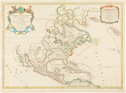
Sold2015Map of North America 1719Heading: (North America) Author: Sanson, Nicolas/ Hubert Jaillot Title: Amerique Septentrionale divisée en ses Principales Parties, ou sont distingués les uns des autres les Estats suivant quils appSee Sold Price
Sold20221765 Atlas Map of North + South AMERICA, ExpillyHistoric Maps 1765 Atlas Map of North and South AMERICA by Expilly 1765 Copper Engraved Atlas Map of North and South AMERICA titled, "AMERIQUE Septentrionale et Meridionale," from Le Geographe ManuelSee Sold Price
5 days LeftJasper52AMAZONIA showing "El Dorado?" & Missions. Brazil Ecuador Colombia SDUK 1874 map$120
5 days LeftJasper52AMAZONIA.Showing "El Dorado?", missions & tribes. Brazil Ecuador.SDUK 1844 map$130
Featured5 days LeftJasper52SOUTH AMERICA NORTH. Peru/Ecuador borders as pre 1941 war. JOHNSTON 1913 map$8
5 days LeftJasper52South America, North. Amazonia Brazil Venezuela Colombia Ecuador TIMES 1900 map$40