Sold20221720 Homann Map of Siege of Belgrade -- Neu-Geographisch Vorgestelltes Ungarisches Kriegs-TheatrumTitle: 1720 Homann Map of Siege of Belgrade -- Neu-Geographisch Vorgestelltes Ungarisches Kriegs-Theatrum in Servien und dem Bannat Temeswar ... 1716 und 1717 Cartographer: J Homann Year / Place: 1720See Sold Price
Sold202417TH C. ANTIQUE MAP SIEGE OF LA ROCHELLE, FRANCE, FRAMED"Seige et Reddition de La Rochelle, Octobre 1628", handcolored engraving on wove paper, Claes Jansz. Visscher (II), (workshop of), Germany, 1627 - 1629. In gilt molded frame, matted under UV non-glareSee Sold Price
Sold2022Rare map Siege of Charleston in Amer. Rev. War, Marshall 1832Rare plan of the Revolutionary War Siege of Charleston in South Carolina. From John Marshall’s 1832 edition of the Life of Washington. Covers the area comprising Charleston Harbor and parts of the CSee Sold Price
Sold2022Rapkin, John 1858 Antique Map. Siege of Sebastopol, CrimeaSteel Engraved Map Published 1858 by the London Printing and Publishing Co., London for "The History Of The War With Russia: Giving Full Details Of The Operations Of The Allied Armies" by Henry TyrrelSee Sold Price
Sold2017Late 16th Century Maps, Incl. Siege of La Rochelle &Two maps on one sheet. Hand-colored map of Ghent (approx. 8.5 x 11 in.), tipped onto reverse side of page with map of the Siege of La Rochelle (approx. 8.25 x 11 in. plate size). Both maps printed witSee Sold Price
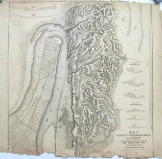
Sold20231893 Civil War Map of Siege of Vicksburg and Vicksburg to Jackson, Miss. -- …Siege of Vicksburg …Title: 1893 Civil War Map of Siege of Vicksburg and Vicksburg to Jackson, Miss. -- …Siege of Vicksburg … [with] …Country Between Milliken's Bend, LA and Jackson, Miss… [Plate XXXVI] CartographSee Sold Price
Sold2021Rapkin, John 1857 HC Map of Siege of Sebastopol, CrimeaHand Colored Steel Engraved Map Published 1857, London for "England's Battles by Sea and Land..." by Lieut-Colonel Williams. Centre fold as issued. Drawn & Engraved by John Rapkin. Paper Size: 14 x 10See Sold Price
Sold2021Rapkin, John 1857 HC Map of Siege of Sebastopol, CrimeaHand Colored Steel Engraved Map Published 1857, London for "England's Battles by Sea and Land..." by Lieut-Colonel Williams. Centre fold as issued. Drawn & Engraved by John Rapkin. Paper Size: 14 x 10See Sold Price
Sold20151756 PETRONIUS SATYRICON, Vols. I & II CritiqueComplete set of the two volumes of Petronius's Satyricon, published in Amsterdam in 1756. Based on the manuscripts found by Du Pin during the Siege of Belgrade (1688). Latin and French language on facSee Sold Price
Sold20241893 Civil War Maps of Vicksburg and Jackson Areas and Battles -- …Defenses of Vicksburg,Title: 1893 Civil War Maps of Vicksburg and Jackson Areas and Battles -- …Defenses of Vicksburg, Miss… [with] …Map of Siege of Jackson, Miss… [with] …vicksburg and ViciniSee Sold Price
Sold201818th C. Spanish Oil, Map of the Siege of BarcelonaContinental School, likely Spanish, late 18th century Overhead landscape painting depicting a stylized map view of Barcelona as seen in 1705, bearing inscription loosely translating to "The Viceroy VeSee Sold Price
Sold20181573 Map of the Siege of La Rochelle -- [Untitled]Title/Content of Map: 1573 Map of the Siege of La Rochelle -- [Untitled] Siege of La Rochelle Date Printed: 1573 c. Cartographer: Anonymous Size: 9 x 11.1 in. A very interesting map of the Siege of LaSee Sold Price
Sold2017Map of the Siege of Vicksburg, MississippiMap: Map of the Siege of Vicksburg, Mississippi Description: This large battle map identifies Union and Confederate entrenchments. It is very detailed, showing the roads, streets, houses, railroads, vSee Sold Price
Sold20211762 Map of the Siege of HavanaAuthor: Kitchin Title: 1762 Map of the Siege of Havana Materials: Ink on Paper Dimensions: 7"X4.5" Description: Map of the siege of Havana and the Moor Castle dated 1762. Engraved and published by ThoSee Sold Price
Sold2018German Historic War Maps, Towns, and Sieges17th and 18th Century German Cartography School, Various Maps showing Battles, Settlements, Wars at German, Swedish, and Dutch Cities, copperplate engravings, approximately 12 x 14.5 inches, approximaSee Sold Price
Sold2016Siege of Turin Map and EngravingEngraving on laid paper with watercolor. Later laid to paperboard. The battle and Siege of Turin in 1706 depicted by Johann August and Jeremias Wolff. Framed under glass not inspected out of the frameSee Sold Price
Sold2021Siege of Vicksburg Map (Civil War)Siege of VicksburgThe Siege of Vicksburg The siege of Vicksburg (May 18 – July 4, 1863) was the final major military action in the Vicksburg campaign of the American Civil War.See Sold Price
Sold2023TRANSYLVANIA ROMANIA Railways Bucharest Belgrade Timisoara Cluj-Napoca 1896 mapTITLE OF THE MAP: 'Transylvania and Roumania showing the Railway & Steamboat communication and the chief roads; Inset Lemberg-Czernowitzer Eisenbahn; Ismail' DATE PRINTED: 1896 IMAGE SIZE: Approx 29.5See Sold Price
Sold2023Jefferys, Authentic Plan of the River St. Laurence - First StateJEFFERYS, Thomas (c. 1719 - 1771). An Authentic Plan of the River St. Laurence from Silleru to the Fall of Montmorenci with the operations of the Siege of Quebec... Engraved map with original hand colSee Sold Price
Sold2022A Plan of the Siege of the Havana… Cuba. Gentleman's Magazine 1762 old mapTITLE/CONTENT OF MAP: 'A Plan of the Siege of the Havana Drawn by an Officer on the Spot 1762' DATE PRINTED: 1762 IMAGE SIZE: Approx 19.0 x 26.0cm, 7.5 x 10.25 inches (Medium); Please note that this iSee Sold Price
Sold2017Anonymous: Antique Map Plan of Havana, 1766Title/Content of Map: A Plan of the Siege of the Havana, drawn by an Officer on the Spot, 1762 Date Printed: 1766 Cartographer: Anonymous Size (inches): 11 x 7 Antique map or plan of Havana, Cuba. ThiSee Sold Price
Sold2024German Map of ParisGerman, 1870, map of Paris outlining the Siege of Paris, 12 1/2" x 15" sight size, 16 1/2" x 18 3/4" framed.See Sold Price
Sold2020Civil War MapAuthor: Steele Title: Civil War Map Medium: Ink on paper Dimensions: 18"X13" Map dated 1942 capturing the siege of Petersburg. Part of the Atlas that accompanied Steele's American Campaigns. This AtlaSee Sold Price
Sold2018William Howard Russell THE BRITISH EXPEDITION TO THEWilliam Howard Russell THE BRITISH EXPEDITION TO THE CRIMEA 1877 Folding Maps/Charts History Crimean War Siege Sevastopol Charge Light Brigade Russia Ottoman Empire Balkans Alma Treaty of Paris Title:See Sold Price
2 days LeftJasper52The town & castle of St. Augustine. 1740 siege. Spanish Florida. SILVER 1740 map$300
2 days LeftJasper52Delineatio Geometrica Urbis Haffniae Daniae… Copenhagen. DAHLBERGH 1696 map$320
5 days LeftBrunk AuctionsExceptionally Rare Price-Strother Survey of North Carolina Map, c. 1808$60,000
3 days LeftSwann Auction GalleriesHENRY F. WALLING (1825-1889) Map of the City of New York and Its Vicinity. 1866.$1,900
3 days LeftFrost & NicklausJaroslav Cermak, Episode in the Siege of Naumburg, Photogravure Goupil 1882$20
5 days LeftBrunk AuctionsJohn Mitchell - A Map of the British and French Dominions in North America, 1755-1757$24,000
Oct 27Schilb Antiquarian Rare Books1764 OTTOMAN WARS Turkey Murad I Battle of Vienna MAP Hapsburgs Islam Muslim$36(4 bids)
300 Lots AwayFlannery's Estate ServicesThe Ponderosa Ranch Map From The Bonanza Television Series Signed$50
Oct 12JM Hobby Supply and Railroad Artifact AuctionsPathfinder Birds Eye Map of Interurban Trolley Lines in New England-1905$40(1 bid)
3 days LeftLeland LittleRobert de Vaugondy's 18th-Century French Map of North America's Eastern Seaboard$50


![1893 Civil War Map of Siege of Vicksburg and Vicksburg to Jackson, Miss. -- …Siege of Vicksburg …: Title: 1893 Civil War Map of Siege of Vicksburg and Vicksburg to Jackson, Miss. -- …Siege of Vicksburg … [with] …Country Between Milliken's Bend, LA and Jackson, Miss… [Plate XXXVI] Cartograph](https://p1.liveauctioneers.com/5584/293457/155766038_1_x.jpg?height=310&quality=70&version=1687903812)


![1893 Civil War Maps of Vicksburg and Jackson Areas and Battles -- …Defenses of Vicksburg,: Title: 1893 Civil War Maps of Vicksburg and Jackson Areas and Battles -- …Defenses of Vicksburg, Miss… [with] …Map of Siege of Jackson, Miss… [with] …vicksburg and Vicini](https://p1.liveauctioneers.com/5584/325789/175390306_1_x.jpg?height=310&quality=70&version=1713301948)

![1573 Map of the Siege of La Rochelle -- [Untitled]: Title/Content of Map: 1573 Map of the Siege of La Rochelle -- [Untitled] Siege of La Rochelle Date Printed: 1573 c. Cartographer: Anonymous Size: 9 x 11.1 in. A very interesting map of the Siege of La](https://p1.liveauctioneers.com/5584/124870/63536014_1_x.jpg?height=310&quality=70&version=1531863645)


![[MAPS] MISC CANADA/AMERICA. LOT OF 6 (1 of 6)](https://p1.liveauctioneers.com/8124/343618/186530170_1_x.jpg?height=282&quality=70&version=1726178725)


