Sold2024Adams' Synchronological Chart Or Map Of History, John E. Colby, Colby & Company, 1880Adams' Synchronological Chart Or Map Of History, John E. Colby, Colby & Company, 1880. Includes Chart & Key. Chart (folded) approximately 28.25L x 14.0W x 0.75D in. Key approximately 6.5H x 4.See Sold Price
Sold2021Adams Synchronological Chart or Map of HistoryAdams Synchronological Chart or Map of History.See Sold Price
Sold2022Adams Syn Chronological Chart/ Map of History, 1976Description: Adams Syn Chronological Chart or Map of History, 1976, printed by 'Strobridge & Co. Lith. Cincinnati, O.', copyright 1876 'Centennial Edition', a chronological chart of ancient, modeSee Sold Price
Sold2022History of Civilization 4 Panel Decoupage ScreenAdams syn chronological chart of map of history. Closed screen measures approx 66H x 17W inches. Wear to piece consistent with use and age. Some peeling of paint and scratches to piece. Screen, room dSee Sold Price
Sold2020Antique Adams Syn Chronological Map of HistoryAntique Adams Syn Chronological Chart or Map of History Book of Oversized Coated Color Illustrated Cloth Continuous Map of the World with History , Dated 1884. Fifth edition by Colby & Co. Publishers,See Sold Price
Sold2023Sebastian C. Adams - Synchronological Chart, Illustrated Panorama of History, Chronological Chart ofLot 56 Sebastian C. Adams American (1825-1928) Synchronological Chart, Illustrated Panorama of History, Chronological Chart of Ancient Modern and Biblical History with Maps , Group of 3 (1884) chromoSee Sold Price
Sold20201846 Holy Bible, Old and New Testament, 14 Maps, Charts1846 Beautiful Holy Bible, Old and New Testament, 14 Maps, Charts Illustrated with 14 Colored Maps and Folding Chart. Containing the Old and New Testaments, with The Parallel Passages and ExplanatorySee Sold Price
Sold20201846 Holy Bible, Old and New Testament, 14 Maps, Charts1846 Holy Bible, Old and New Testament, 14 Maps, Charts Illustrated with 14 Colored Maps and Folding Chart.Containing the Old and New Testaments, with The Parallel Passages and Explanatory Notes.LondoSee Sold Price
Sold2023Thomson, John (Pub) 1825 Map. Chart of the WorldCopper Engraved Map Published 1825 by John Thomson, Edinburgh for "The Edinburgh School Atlas" by N. R. Hewitt. Maps Engraved by Hewitt. Original Outline Hand Colour. Rare. Paper Size: 10.5 x 8 inch (See Sold Price
Sold2021Thomson, John (Pub) 1825 Map. Chart of the WorldCopper Engraved Map Published 1825 by John Thomson, Edinburgh for "The Edinburgh School Atlas" by N. R. Hewitt. Maps Engraved by Hewitt. Engraved Vignette in corner. Original Outline Hand Colour. RareSee Sold Price
Sold2019Derbyshire 19th Century Lot of 7 Antique Maps, ChartLot of six 19th Century Maps and one 18th Century Chart. All Derbyshire. Examples by Lewis, Dugdale, Phillips/Cooper, Weller/Weekly Dispatch and others. Paper Size: Up to 18.5 x 13.5 inch (47 x 34cm)See Sold Price
Sold2022LARGE ARCHITECTS PRINT / MAP / CHART CABINETFantastic very large Architectural draftsman/chart/map/print flat file - George III-Style mahogany with satinwood inlay, inset tooled leather top. 8 Drawer over 4 drawer. from the Audubon Gallery, KinSee Sold Price
Sold2023Corea and Japan by John Thomson. East Asia. Korea 1817 old antique map chartTitle: "Corea and Japan" by John Thomson. East Asia. Korea 1817 old antique map chart Description: Corea and Japan' by Drawn & engraved by John & George Menzies for John Thomson's "New General Atlas"See Sold Price
Sold2022Corea and Japan by John Thomson. East Asia. Korea 1817 old antique map chartTITLE/CONTENT OF MAP: 'Corea and Japan' DATE PRINTED: Published in 1817. Engraved on 16th August 1815; this date is marked on the map IMAGE SIZE: Approx 52.5 x 67.0cm, 20.75 x 26.5 inches (Large); PleSee Sold Price
Sold2022Corea and Japan by John Thomson. East Asia. Korea 1830 old antique map chartTITLE/CONTENT OF MAP: 'Corea and Japan' DATE PRINTED: 1830 IMAGE SIZE: Approx 52.0 x 66.5cm, 20.5 x 26.25 inches (Large); Please note that this is a folding map. TYPE: Antique early 19th century atlasSee Sold Price
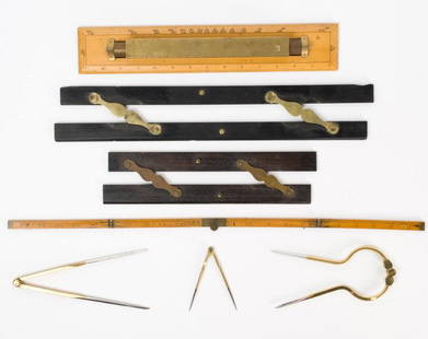
Sold2021Antique & Vintage Marine Map Chart AccessoriesA group of six very good marine map chart accessories, consisting of: two antique ebony & brass parallel rules - the 12" rule stamped THREADWELL LONDON, the 18" rule with minor chips, a 15" antique brSee Sold Price
Sold20231763 Map Chart of Polar Circle and MagazineChart of the Antarctic Polar Circle with the Countries Adjoining, According to a New Hypothesis of Mr. Bauche, from the memoirs of the Royal Academy of Paris, published for Gentleman's Magazine JanuarSee Sold Price
Sold2017Map Chart of South & North America, R di RattiMap Chart of North and South America. 'Nova Totius Terrarum Geographica AC Hydrographica". Vintage silk work by R di Ratti, signed. Likely based on a map chart by Willem Blaeu circa 1640.See Sold Price
Sold2022CUBA PUERTO RICO Jamaica Haiti. Caribbean. BAEDEKER 1909 old antique map chartTITLE OF MAP (NOT PRINTED ON THE PAGE):'Cuba and Porto Rico' Places shown on the map include: Jamaica Puerto Rico Haiti DATE PRINTED: 1909 IMAGE SIZE: Approx 10.0 x 15.0cm, 4 x 5.75 inches (Small) TYPSee Sold Price
Sold2023Tehran town/city plan. Iran. Teheran. BAEDEKER 1912 old antique map chartTITLE/CONTENT OF MAP: Teheran [Tehran] DATE PRINTED: 1912 IMAGE SIZE: Approx 15.0 x 16.0cm, 6 x 6.25 inches (Medium); Please note that this is a folding map. TYPE: Antique German language tourist mapSee Sold Price
Sold2024James Cook - Map / Chart Of The Island TahitiEngraved nautical map from the 1774 first French edition of the first map of New Zealand, illustrating Lieutenant James Cook's 1769 exploration of the passage between New Zealand's North and South islSee Sold Price
Sold2016AE Hall Great War Illustrated Photos Maps Charts 1History And Rhymes Of Lost Battalion Beck Pvt. McCollum, Stories Of Americans in World War Charles Merrill Co. Publisher William Allen. 3 PiecesSee Sold Price
Sold2024L' Asie. Asia Tartary China Mughal Empire. BUFFIER c1818 old antique map chartCAPTION PRINTED BELOW PICTURE: L' Asie [Asia] DATE PRINTED: c1818 IMAGE SIZE: Approx 14.0 x 18.0cm, 5.5 x 7 inches (Medium); Please note that this is a folding map. TYPE: Antique engraved map CONDITIOSee Sold Price
Sold2023World's highest waterfalls & biggest lakes. HUGHES 1876 old antique map chartTITLE/CONTENT OF MAP: 'Waterfalls. Lakes' DATE PRINTED: 1876 IMAGE SIZE: Approx 25.0 x 30.5cm, 9.75 x 12 inches (Large) TYPE: Antique hand coloured engraved map CONDITION: Good; suitable for framing.See Sold Price
Featured1 day LeftJasper52The Bahamas, Cuba & Bermuda "or Summer Islands". THOMSON 1817 old antique map$190
1 day LeftJasper52Cuba, the Bahamas & Bermuda "or Summer Islands". Turks & Caicos THOMSON 1830 map$170


![[MAPS] Deacon's Synchronological Chart First Image](https://p1.liveauctioneers.com/8597/316632/169944313_1_x.jpg?height=300&quality=1&version=1705648710&width=300)
![[MAPS] Deacon's Synchronological Chart First Image](https://p1.liveauctioneers.com/8597/316632/169944313_1_x.jpg?height=300&quality=95&version=1705648710&width=300)


![Tehran town/city plan. Iran. Teheran. BAEDEKER 1912 old antique map chart: TITLE/CONTENT OF MAP: Teheran [Tehran] DATE PRINTED: 1912 IMAGE SIZE: Approx 15.0 x 16.0cm, 6 x 6.25 inches (Medium); Please note that this is a folding map. TYPE: Antique German language tourist map](https://p1.liveauctioneers.com/5584/278338/146429650_1_x.jpg?height=310&quality=70&version=1676415582)


![L' Asie. Asia Tartary China Mughal Empire. BUFFIER c1818 old antique map chart: CAPTION PRINTED BELOW PICTURE: L' Asie [Asia] DATE PRINTED: c1818 IMAGE SIZE: Approx 14.0 x 18.0cm, 5.5 x 7 inches (Medium); Please note that this is a folding map. TYPE: Antique engraved map CONDITIO](https://p1.liveauctioneers.com/5584/329387/177649271_1_x.jpg?height=310&quality=70&version=1715717898)


