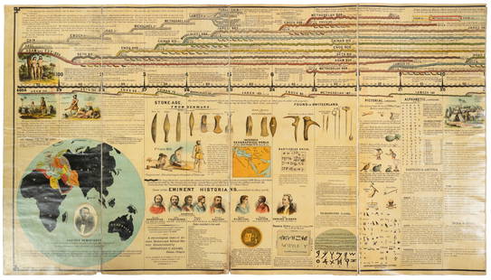
Sold2024Adams' Synchronological Chart Or Map Of History, John E. Colby, Colby & Company, 1880Adams' Synchronological Chart Or Map Of History, John E. Colby, Colby & Company, 1880. Includes Chart & Key. Chart (folded) approximately 28.25L x 14.0W x 0.75D in. Key approximately 6.5H x 4.See Sold Price
Sold2021Adams Synchronological Chart or Map of HistoryAdams Synchronological Chart or Map of History.See Sold Price
Sold2022Adams Syn Chronological Chart/ Map of History, 1976Description: Adams Syn Chronological Chart or Map of History, 1976, printed by 'Strobridge & Co. Lith. Cincinnati, O.', copyright 1876 'Centennial Edition', a chronological chart of ancient, modeSee Sold Price
Sold2022History of Civilization 4 Panel Decoupage ScreenAdams syn chronological chart of map of history. Closed screen measures approx 66H x 17W inches. Wear to piece consistent with use and age. Some peeling of paint and scratches to piece. Screen, room dSee Sold Price
Sold2020Antique Adams Syn Chronological Map of HistoryAntique Adams Syn Chronological Chart or Map of History Book of Oversized Coated Color Illustrated Cloth Continuous Map of the World with History , Dated 1884. Fifth edition by Colby & Co. Publishers,See Sold Price
Sold2023Sebastian C. Adams - Synchronological Chart, Illustrated Panorama of History, Chronological Chart ofLot 56 Sebastian C. Adams American (1825-1928) Synchronological Chart, Illustrated Panorama of History, Chronological Chart of Ancient Modern and Biblical History with Maps , Group of 3 (1884) chromoSee Sold Price
Sold2016Vintage Adams Map of History BookAdams Map of History book. Vintage reproduction of the famous illustrated time line of earth's history, 1st published in 1871. Hard cover. 13" W x 27 1/2" H.See Sold Price
Sold2024ADAMS SYN CHRONOLOGICAL CHART PUBLISHED BY COLBY & CO. NY 19TH CENTURY FOLDS OUT TO TWENTY FEET 28" X 20' PLEASE READ CAREFULLY - Terms for Purchasing and Shipping of Auction Items. Please read carefully before bidding. All paymenSee Sold Price
Sold2021Set 8 of School Charts - Texas History and ResourcesSet 8 of Vintage School Charts Maps - Texas History and Resources36 in tall x 45 x 1 - Denoyer - Geppert of Chicago / J. L Clark & Lewis W. NewtonSee Sold Price
Sold2018William Howard Russell THE BRITISH EXPEDITION TO THEWilliam Howard Russell THE BRITISH EXPEDITION TO THE CRIMEA 1877 Folding Maps/Charts History Crimean War Siege Sevastopol Charge Light Brigade Russia Ottoman Empire Balkans Alma Treaty of Paris Title:See Sold Price
Sold2021United States History - Synchronic ChartsUnited States History with Synchronic Charts Maps and Statistical Diagrams. History Made Visible - National Edition. Large colar folding chart. Few written pages of notes.See Sold Price
Sold2017Wilkinson: Antique Text Map of Empires of World, 18141814 Map/Text Map of Empires of the World by Wilkinson. Fascinating and unusual chart/map showing the great empires and nations in man’s history. Vertical sections depict each century starting beforSee Sold Price
Sold2024William Hole "A Description of the land of Gosen, and Moses passage though the Deserts"Map from Raleigh's History of the world 1652. This map charts the legendary journey of Moses, leading the Israelites out of Egyptian captivity. It depicts their escape route, including the dramatic paSee Sold Price
Sold2016AE Hall Great War Illustrated Photos Maps Charts 1History And Rhymes Of Lost Battalion Beck Pvt. McCollum, Stories Of Americans in World War Charles Merrill Co. Publisher William Allen. 3 PiecesSee Sold Price
Sold20187V History Books DECORATIVE ANTIQUE BINDINGS Gilt7V History Books DECORATIVE ANTIQUE BINDINGS Gilt Leather Marbled Paper Girondists Lamartine Oeuvres Volney Folding Maps Tables Charts Memoirs Duke Sully English History Ancient Book Details: This grSee Sold Price
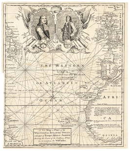
Sold20171740 Ornate Copperplate Engraved Portrait MapHistoric Maps 1740 Ornate Copperplate Engraved Map with Portraits of British Admirals “Robert Blake” & “Edward Vernon, Esq.” 1740-Dated, Copperplate Engraved Map titled “A New Map or Chart oSee Sold Price
Sold2021Sebastian C. Adams. A Chronological Chart of Ancient,Sebastian c. Adams (1825-1928 - Salem, OR). A Chronological Chart of Ancient, Modern and Biblical History. Teaching Scroll Inside Original Frame & Glass. Rare 1800's Wall Chart. Time-Line Chart Of HisSee Sold Price
Sold2021Scarce Genealogical h/c chart from Creation to Saul,Large format, two-page foldout tracing Creation to the first king of Israel. Shown in blocks of period hand-coloring for clarity. Genealogical, Historical and Chronological Map of SACRED HISTORY, fromSee Sold Price
Sold20241766 Emanuel Bowen "The Maps And Charts Of The Modern Part Of The Universal History"Printed for T. Osborne, A. Millar, J Rivington, B. Law And Co., T. Longman, C. Ware, and S. BladonSee Sold Price
Sold2021History of the Royal Regiment of ArtilleryTwo volumes. Publishers blue cloth cover with gilt title and crest. Pictorial dust-jacket. Full-page plates, maps and charts. Volume I. 1992. "Between the Wars, 1919-39." Volume II. 1996. "The Years oSee Sold Price
Sold2023Ridpath Pop. Hist. of the United States, 1877Thick book comprising the breadth of American history, up to and including the Grant administration. Illustrated with many maps, engravings, charts and diagrams and numerous full-color maps, some two-See Sold Price
Sold2022A Chronological Chart of Ancient & Modern HistoryHeading: Author: Adams, Sebastian C. Title: A Chronological Chart of Ancient, Modern and Biblical History. Synchronized by Sebastian C. Adams Place Published: Cincinnati, OH Publisher:Strobridge & CoSee Sold Price
Sold2023Baines, Edward 1817 Antique Map. Europe according to the Treaty of Vienna"Chart Illustrative of the Campaigns of the Wars of the French Revolution" Copper Engraved Map Published 1817, London for "History of the Wars of the French Revolution..." by Edward Baines. Folds as iSee Sold Price
Sold2020Lyttleton, George 1810 Map of The English Channel"Chart of the British Channel with the opposite Coast of the United Kingdom, and the Republic of France" Copper Engraved Map Published 1810, London for "The History of England..." by George Courtney LSee Sold Price
17 hrs LeftZikorn Arts & History ObjectsWest Indies, Providence, Windward, Cuba 1834 British Admiralty Map$100(1 bid)
17 hrs LeftZikorn Arts & History ObjectsEntrance to Baltic Great & Little Belt 1852 British Admiralty Map$100
17 hrs LeftZikorn Arts & History ObjectsWest Indies, Eastern Cuba 1881 British Admiralty Nautical Map$100
17 hrs LeftZikorn Arts & History ObjectsCentral America West Coast 1855 British Admiralty Nautical Chart$100(1 bid)
17 hrs LeftZikorn Arts & History ObjectsWest Indies, Western Cuba 1879 British Admiralty Nautical Map$100
17 hrs LeftZikorn Arts & History ObjectsWest Indies Pt. Manzanilla to San Juan 1844 British Admiralty Map$100
17 hrs LeftZikorn Arts & History ObjectsWest Indies, Cape Gracias to Belize 1843 British Admiralty Map$100
42 mins LeftJasper52Europe from the best authorities by Richard Brookes 1812 old antique map chart$30
42 mins LeftJasper52Scandinavia Russia sea chart. Ports lighthouses. Arctic Ocean Bothnia 1918 map$20
42 mins LeftJasper52Scandinavia Russia sea chart. Ports lighthouses. Arctic Ocean Bothnia 1916 map$20
42 mins LeftJasper52Eastern Europe sea chart Ports Lighthouses mail route Black Sea Baltic 1916 map$40