Sold2017Rand McNally Pocket Map & Shippers Guide of Alaska 1912Map: Rand, McNally & Co.'S Indexed County and Township Pocket Map And Shippers' Guide of Alaska Publication Date: 1912 Author: RAND, MCNALLY & COMPANY, RAND, MCNALLY & CO. Publisher: RAND, MCNALLY & CSee Sold Price
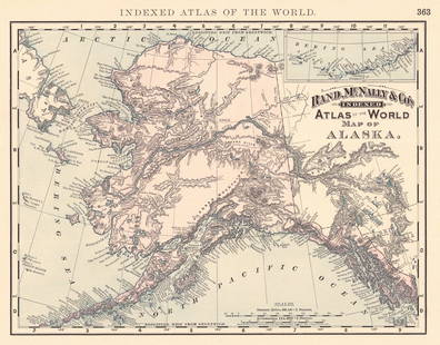
Sold2024Rand, McNally & Co.'S Indexed Atlas of the World Map of AlaskaTitle:Rand, McNally & Co.'S Indexed Atlas of the World Map of Alaska Publication Date: 1892 Cartographer:RAND, MCNALLY & CO. Publisher: RAND, MCNALLY & CO. Height: 9.3 Width: 11.8 Map showing AK withSee Sold Price
Sold2017McNally: Map of Nevada, 1898Detached leaf from the Indexed Atlas of the World. Colored print, each county a different color, with lots of detail regarding mountains, rivers, etc. Written information about Alaska on the verso[NevSee Sold Price
Sold2023Alaska 1895Title/Content of Map: Alaska 1895 Date Printed: 1895 Material/Medium: paper Size: 10.75"x13.75" Rand, McNally & Co. Reserve: $35.00 Shipping: Domestic: Flat-rate of $15.00 to anywhere within the contSee Sold Price
Sold2023Los Angeles Maps and Ephemera [148417]Lot of 22 One Souvenir Sombrero (2") pin ad for L.A. Times (possibly 1920's). 7 road maps from AAA, Mobile gas, Texaco, Rand McNally. Pictorial postcard 12 pack (1948), Four Gray Line tour schedules (See Sold Price
Sold20211897 Rand McNally Map of Pacific Northwest -- MapTitle: 1897 Rand McNally Map of Pacific Northwest -- Map Showing Routes of the Pacific Coast Steamship Company Cartographer: Rand McNally Year / Place: 1897, Chicago Map Dimension (in.): 27 X 12.6 in.See Sold Price
Sold20231st ed. near pristine McNally map of Calif. and Nevada, 1881Large format and highly detailed scarce map of California and Nevada. Rand, McNally & Co.’s California, published 1881 (dated first edition). Shows railroads, towns, rivers, topography, lakes, cSee Sold Price
Sold20221st ed. near pristine McNally map of Texas & Ind. Terr., 1881Highly detailed and scarce large format railroad map, one of the best of the period. Rand, McNally & Co.’s Texas and Indian Territory, dated 1881 (first edition). This great map depicts railroadSee Sold Price
Sold2016VINTAGE RAND McNALLY MAP DISPLAY w/ MAPSVery early Rand McNally display Comes full of vintage maps. 19"x7" Very GoodSee Sold Price
Sold20211869 McNally Map of Texas, Indian Territory and NewTitle: 1869 McNally Map of Texas, Indian Territory and New Mexico -- Texas, New Mexico, and Indian Territory Cartographer: F McNally Year / Place: 1869, New York Map Dimension (in.): 8.3 X 10.6 in. ThSee Sold Price
Sold2024Framed Space Age Rand McNally Map of Planets Poster, 1958Framed Rand McNally Map of Outer Space Astronomy Poster, 1958. This large print of the planets and stars, with astronomical science and math facts, may have been used in a classroom school setting forSee Sold Price
Sold2017Rand McNally: Map of Texas from Jones & Hamilton AtlasEarly Rand McNally vertical format Texas map from scarce 1876 Jones & Hamilton atlas. Large and uncommon McNally vertical format map of Texas from the scarce 1876 Jones & Hamilton Historical Atlas ofSee Sold Price
Sold20221866 McNally Map of Texas -- TexasTitle: 1866 McNally Map of Texas -- Texas Cartographer: McNally & Co. Year / Place: 1866, New York Map Dimension (in.): 8.3 X 10.6 in. This is an outstanding and seldom seen map of Texas from just 21See Sold Price
Sold2017McNally: Map of Texas, New Mexico, Indian TerritoryMap of Texas, New Mexico and Indian Territory. McNally's System of Geography. 1875. 12 x 10 inches. Inset showing Vicinity of Galveston Please note that this lot has a confidential reserve. When you lSee Sold Price
Sold20181895 Rand McNally Map of Texas and Indian TerritoryTitle/Content of Map: 1895 Rand McNally Map of Texas and Indian Territory/Oklahoma -- Texas; Oklahoma and Indian Territory Date Printed: 1895 Chicago Cartographer: Rand McNally Size: 9.2 x 12.5 in. ThSee Sold Price
Sold20201898 Rand McNally Map of Texas and IndianTitle/Content of Map: 1898 Rand McNally Map of Texas and Indian Territory/Oklahoma -- Texas; Oklahoma and Indian Territory Date: 1898, Chicago Cartographer: Rand McNally Size: 9.2 x 12.5 in. This mapSee Sold Price
Sold20201892 Rand McNally Map of Chicago -- Railway TerminalTitle/Content of Map: 1892 Rand McNally Map of Chicago -- Railway Terminal Map of Chicago Cartographer: Rand McNally Year/Place: 1892, Chicago Size: 26 x 18.9 in. This is a quite large and detailed maSee Sold Price
Sold20241898 Rand McNally Map of Texas [verso] Indian Territory and Oklahoma -- Texas [verso] Oklahoma andTitle: 1898 Rand McNally Map of Texas [verso] Indian Territory and Oklahoma -- Texas [verso] Oklahoma and Indian Territory Cartographer: Rand McNally Year / Place: 1898, Chicago Map Dimension (in.): 9See Sold Price
Sold20201895 Rand McNally Map of Texas and IndianTitle: 1895 Rand McNally Map of Texas and Indian Territory/Oklahoma -- Texas; Oklahoma and Indian Territory Cartographer: Rand McNally Year/Place: 1895, Chicago Size: 9.2 x 12.5 in. Description: ThisSee Sold Price
Sold20231895 Rand McNally Map of New Orleans [verso] Louisiana -- Louisiana [verso] New OrleansTitle: 1895 Rand McNally Map of New Orleans [verso] Louisiana -- Louisiana [verso] New Orleans Cartographer: Rand McNally Year / Place: 1895, Chicago Map Dimension (in.): 12.4 X 9.4 in. This is a highSee Sold Price
Sold2017Rand McNally: Map of Indian Territory, 1882Indian Territory, Rand McNally, 1882. 13 x 19.25 inches. Signature map of Indian Territory from the exceedingly hard to find 1882 version of McNally’s Indexed Atlas of the World. Highly detailed witSee Sold Price
Sold20171911 Rand McNally Map of Brooklyn (Buffalo verso)Item: 1911 Rand McNally Map of Brooklyn (Buffalo verso) Description: A map of Brooklyn with Buffalo on verso. Highly detailed as to street names, key buildings (e.g.: Brooklyn Intitute of Arts and SciSee Sold Price
Sold2016Rand McNally: Map of Northern California, 1882Map: Northern California Maker: Rand McNally Date: 1882 Origin: Chicago Size: 19.8 x 12.8 inches Very nice map of Northern California, San Jose and north. Great deal of detail as to towns, railroads,See Sold Price
Sold20181896 Rand McNally Map of Texas and Indian TerritoryTitle/Content of Map: 1896 Rand McNally Map of Texas and Indian Territory/Oklahoma -- Texas [verso] Oklahoma and Indian Territory Date Printed: 1896 Chicago Cartographer: Rand McNally Size: 9.2 x 12.5See Sold Price
3 days LeftJasper521894 Rand McNally Map of British Columbia -- Indexed Atlas of the World Map of British Columbia$35
3 days LeftJasper521901 Rand McNally Map of US West -- New Commersial Map of Denver to Pacific Coast$55
Oct 06Schilb Antiquarian Rare Books1897 Alaska & Klondike 1ed Gold Fields Canada INDIANS Cannibalism Slavery MAPS$52(4 bids)
Oct 12JM Hobby Supply and Railroad Artifact Auctions1879 Rand McNally Township County and Railroad Map of Illinois$40
3 days LeftJasper52Rand, McNally & Co.'S Indexed County & Railroad Pocket Map And Shippers' Guide of Kentucky$80
3 days LeftJasper52Austria-Hungary Rand, McNally & Co.'S Indexed Atlas of the World Map of Austria-Hungary.$70
3 days LeftJasper52Rand, McNally & Co.'S Indexed Atlas of the World Map of Germany (Western Sheet). | (Eastern Sheet).$60
Oct 12JM Hobby Supply and Railroad Artifact AuctionsChicago Great Western RY June 13, 1920 Public Timetable$20(2 bids)


![Los Angeles Maps and Ephemera [148417]: Lot of 22 One Souvenir Sombrero (2") pin ad for L.A. Times (possibly 1920's). 7 road maps from AAA, Mobile gas, Texaco, Rand McNally. Pictorial postcard 12 pack (1948), Four Gray Line tour schedules (](https://p1.liveauctioneers.com/2699/274457/144083332_1_x.jpg?height=310&quality=70&version=1672962673)


![1898 Rand McNally Map of Texas [verso] Indian Territory and Oklahoma -- Texas [verso] Oklahoma and: Title: 1898 Rand McNally Map of Texas [verso] Indian Territory and Oklahoma -- Texas [verso] Oklahoma and Indian Territory Cartographer: Rand McNally Year / Place: 1898, Chicago Map Dimension (in.): 9](https://p1.liveauctioneers.com/5584/329422/177662173_1_x.jpg?height=310&quality=70&version=1715717898)

![1895 Rand McNally Map of New Orleans [verso] Louisiana -- Louisiana [verso] New Orleans: Title: 1895 Rand McNally Map of New Orleans [verso] Louisiana -- Louisiana [verso] New Orleans Cartographer: Rand McNally Year / Place: 1895, Chicago Map Dimension (in.): 12.4 X 9.4 in. This is a high](https://p1.liveauctioneers.com/5584/283091/149355547_1_x.jpg?height=310&quality=70&version=1680038985)


![1896 Rand McNally Map of Texas and Indian Territory: Title/Content of Map: 1896 Rand McNally Map of Texas and Indian Territory/Oklahoma -- Texas [verso] Oklahoma and Indian Territory Date Printed: 1896 Chicago Cartographer: Rand McNally Size: 9.2 x 12.5](https://p1.liveauctioneers.com/5584/120548/61369196_1_x.jpg?height=310&quality=70&version=1524013707)


